Weather Forecasts, Facts and News for Winnipeg & Southern Manitoba
Author: Brad
Brad lives in Winnipeg with his wife and two children and is the founder of A Weather Moment. He has loved weather from a very young age and has followed that passion through his life so far. He received a B.Sc. in Earth Sciences with Specialization in Atmospheric Sciences and is currently employed in the field of meteorology. You can find the author as WeatherInThePeg on Mastodon.
This week will be quite nice, as a fairly consistent summer-like pattern takes hold.
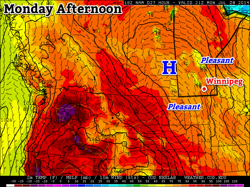
Monday will be a pleasant day in southern Manitoba
Monday
Monday
24°C / 12°C
Mainly Sunny
Today will be coolest day of the week, but that isn’t actually a bad thing in this case. We should see temperatures climb into the low to mid twenties with light northerly wind. Some smoke from forest fires in northern Canada may trickle into southern Manitoba, but otherwise skies should be mainly clear.
Tuesday
Tuesday
26°C / 14°C
Mainly Sunny
Tuesday look very similar to Monday, except it’ll be slightly warmer. Temperatures in the mid twenties are expected once again, with a light northerly wind. Again, there may be a bit of smoke around, but otherwise it’ll be another great day.
Wednesday
Wednesday
28°C / 16°C
Mainly Sunny. Slight chance of a shower or thunderstorm.
Wednesday should see pleasant continue continue. Temperatures will likely reach the upper twenties in most areas, once again under a light northerly flow. Wednesday’s airmass looks to be a bit more humid than what we saw earlier in the week, so a few pop-up showers and/or thunderstorms are possible in the afternoon and evening. However, these will be very hit and miss, so most people will not be affected.
Long Range
The long range forecast is looking good. Models depict a large upper ridge building over the Prairies this week. That should mean generally hot and dry weather for us. Long range models suggest this ridge may stick around for most of the next 10 days.
Unsettled weather will mark the start of the last weekend of July, but conditions will improve for a rather pleasant end and persist into a fairly dry and seasonal start to next week.
Friday: Thunderstorms Possible
Friday
25°C / 15°C
Chance of showers or thunderstorms
Today is off to a cloudy start with a few showers likely through the Red River Valley[1] as the remnants of the overnight activity push off to our east. Skies will remain mostly cloudy until the cold front that brought copious amounts of severe weather to Saskatchewan yesterday pushes through the Red River Valley early this afternoon.
As that cold front moves eastwards, it’s likely that more thunderstorms will fire up along it. Dewpoints in the upper teens will combine with daytime highs in the mid–20’s to produce MUCAPE values as high as 2000J/kg ahead of the front. Shear will be marginal with only around 25–30kt of surface-to–500mb bulk shear and the vertical wind profile isn’t particularly favourable for severe weather. The cold front will be enough of a trigger, although it will be weaker than yesterday and not offer nearly as much forcing as it did then.
As a result, thunderstorms will likely fire up somewhere in the central or eastern Red River Valley and push into the Whiteshell and far SE Manitoba this afternoon. At this point it doesn’t look like there will be an organized severe weather threat, but we’ll be taking a look a little later this morning to assess whether or not the severe threat needs upgrading.
The HRRR forecast shows a line of showers and thunderstorms pushing eastwards along the cold front this morning.
Other than the storms, the day will be pleasant. Before the cold front passes the Red River Valley will be under a relatively light southerly or southeasterly wind. It will be fairly humid and temperatures in the low 20’s until the passage of the front, after which westerly winds at 30–40km/h bring in much drier air. The afternoon sunshine should help our daytime high climb to around 25°C.
Temperatures will drop to around 14°C under clear skies and light winds tonight.
Showery Saturday
Saturday
24°C / 13°C
Mainly cloudy with widespread showers
Tomorrow will be the least pleasant day of the next few. A strong upper-level low will slide across Southern Manitoba through the day, producing widespread showers underneath it. There may be a few isolated thunderstorms, but for the most part most areas in Southern Manitoba will be seeing a fairly wet day. Winds will generally be 20–30km/h through much of the day, shifting from southwesterly or westerly to northerly through the day and overnight.
Skies will begin to clear overnight as the temperature drops to around 13°C.
Sunny Sunday
Sunday
24°C / 13°C
Mainly sunny
Sunday will likely start off with some low cloud trapped in the boundary layer making for mixed to mostly cloudy skies. As the temperature rises through the morning, the clouds will gradually break up leading to a mainly sunny afternoon with some scattered clouds. Highs will be around the 24–25°C mark and temperatures will drop to around 13°C once again on Sunday night.
This pleasant weather will continue through the first half of next week. Another strong ridge is forecast to build into BC/Alberta, which will keep temperatures seasonal[2] and the weather dry.
Full discretion: I’m writing this on Thursday evening, and still unsure on how much of Thursday night’s convective activity will survive to the Red River Valley. ↩
Seasonal highs in Winnipeg right now are around 26°C. Seasonal lows are around 13°C. ↩
Southern Manitoba is in the middle of one of the most pleasant stretches of summer weather so far this year; humidity is relatively low with plenty of sun and daytime highs sitting in the mid-to-upper 20’s. This beautiful weather will continue for another couple days before an upper-level low pressure system begins impacting our region on Friday, bringing unsettled weather back to the region.
Wednesday
26°C / 13°C
Mainly sunny
Thursday
26°C / 18°C
Mixed skies with a chance of showers in the evening
Friday
26°C / 15°C
Chance of [thunder]showers
Today and tomorrow will both be beautiful days with highs around 26°C and light winds as a ridge of high pressure moving through the province quashes any unwelcome weather. Both days will also feature ample sunshine and fairly light winds, although around the end of tomorrow winds will likely begin to pick up out of the southeast to around 20–30km/h. Tonight’s overnight low will hover around 13°C.
Thursday evening will mark the arrival of the leading edge of a major low pressure system developing over the western Prairies. A leading disturbance will swing into Southern Manitoba through the night, bringing a good chance of shower activity to most places[1] with around 5mm of rain expected in most places that see the showers. It may end up being more hit and miss and we’ll be able to refine the forecast as we get closer to the event.
A moderate risk of severe thunderstorms this afternoon will translate into a slight risk over SW Manitoba this evening. See our discussion below.
Perhaps of heightened concern for Thursday evening is the potential for severe thunderstorms over extreme Southwestern Manitoba. It’s worth being aware of the potential at the moment, however there are a lot of potentially complicating factors that will become clear tomorrow as to whether or not that threat will be able to be realized or not. We’ll update in the comments below with more details early in the day on Thursday.
Friday will bring unsettled weather. While morning showers will be possible, the weather will transition into a mix of sun and cloud fairly early before the threat for showers or thunderstorms redevelops in the afternoon. The redevelopment will not affect all of Southern Manitoba; it will mainly be of concern for the Red River Valley/Interlake and areas eastwards. Despite the unsettled weather, temperatures will be warm with highs sitting near 26°C. The humidity will be a little more noticeable, but nowhere near the humid days we’ve had so far this year.
Mixed Weekend
Looking ahead to the weekend, Saturday looks like showers will push through the region through the day underneath the upper-level low as it pushes through. Highs on Saturday will once again be in the mid–20’s. Sunday will be a return to pleasant weather as a ridge of high pressure begins building back into the area. Highs will likely be, you guessed it, in the mid–20’s!
Including the Parkland region, southwest Manitoba, the Red River Valley, southeastern Manitoba and the Interlake. ↩
This week will feature near normal conditions as we cool down a bit from a sultry Sunday.
The weather will be mostly calm in southern Manitoba on Monday, but dangerous storms will be possible south of the border
Monday
Monday
26°C / 16°C
Mix of sun and cloud with a chance of showers
Today will feature near normal weather in southern Manitoba as temperatures climb into the mid twenties. There will be a chance of showers through the day as an upper-level impulse rolls through, but little in the way of accumulation is expected. Despite the calm weather in Manitoba, conditions just south of the border look to be quite different.
A very hot and extremely humid air mass are located over the eastern Dakotas and Minnesota today. This air mass will become extremely unstable by late afternoon, characterized by MLCAPE values of 4000-5000 J/kg (CAPE is a measure the potential energy/fuel for a thunderstorm), or perhaps even higher in localized pockets. Favourable wind profiles will allow for supercell thunderstorms and tornadoes early in this thunderstorm event, but cells will likely transition into a powerful convective system by mid to late evening. Given the potency of the thunderstorm environment tomorrow, all modes of severe weather will be possible, including very large hail and destructive winds. If your travels take you into this region today, you’ll want to pay close attention to the latest weather watches and warnings in the area.
Tuesday
Tuesday
26°C / 14°C
Mix of sun and cloud
Tuesday will be a relatively benign day. Temperatures will once again be in the mid twenties. Precipitation is unlikely as a surface high pressure system builds into Manitoba. Winds will be relatively light and from the north.
Wednesday
Wednesday
27°C / 15°C
Mainly sunny
The surface high from Tuesday looks to stick around for Wednesday, bringing continued pleasant weather to southern Manitoba. Temperatures look to be in the mid to upper twenties with light winds. Some precipitation may edge into western Manitoba late in the day as thunderstorms are potentially triggered to our west in Saskatchewan.
Long Range
The long range forecast looks to have ups and downs. Models strongly suggest that a low pressure system will move into Manitoba late this week, potentially bringing us some rain and generally unsettled conditions. Once that system exits the region we’ll likely return to more summer-like weather next week.