Snow Tapers off With a Cooler Weekend Ahead

Lingering flurries will taper off across southern Manitoba today as the Colorado Low shifts off to the east. Behind it, northerly winds will diminish as cooler temperatures settle into the region.
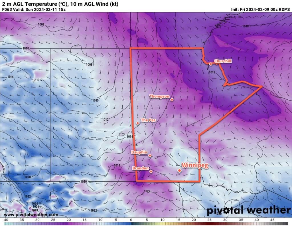
RDPS 2m Temperature Forecast valid 15Z Sunday February 11, 2024
Although it won’t be particularly cold for early February, the weekend will bring cooler temperatures than the region has seen recently.

It will be the most wintery day seen in weeks across southern Manitoba today as snow tapers off and the region is left with northerly winds of 30 to 40 km/h. There may be blowing snow in western Manitoba, but the recent warmth and limited new snow in the Red River Valley should prevent it from being much of an issue here. Notable will be how much cooler it will be in Winnipeg than recently. Despite that, temperatures will stay above normal values across the region. Winnipeg’s daytime high should reach around -8 °C today and mainly cloudy skies will keep things mild tonight with a lows dipping into the -15 to -10 °C range.

Saturday will bring mostly cloudy skies to the region as an upper trough swings into Manitoba. Highs will bounce back to around -5 °C with light northwest winds. Temperatures will dip back to around -10 °C on Saturday night under cloudy skies. There will be a chance of light snow overnight as the upper trough moves through the region.

Winnipeg might see sunshine on Sunday as light southwest winds develop across the region. Daytime highs should reach back into the -5 to 0 °C range as warming moves eastwards across the Prairies with a building upper ridge. Temperatures will dip back down into the -10 to -5 °C range on Sunday night with variable cloudiness.

Long Range Outlook

The first half of next week will bring variable cloudiness to southern Manitoba with northerly winds and daytime highs in the -5 to 0 °C range. A cold front will slump into the region in the second half of the week, bringing near-seasonal temperatures as highs slump towards -10 °C along with a chance of flurries.

Today’s seasonal daytime high in Winnipeg is -9 °C while the seasonal overnight low is -20 °C.

Colorado Low Poised to Bring Fresh Snow to Manitoba as Warm Weather Continues

Cloudy skies, mist/fog, drizzle, and mild temperatures will continue for a couple more days in the Winnipeg area. The weather will finally change across southern Manitoba on Wednesday night as a Colorado Low begins to spread waves of precipitation into the province.

ECMWF Precipitation Type Forecast valid 18Z Thursday February 8, 2024.ECMWF Total Accumulated Snowfall Forecast (10:1 SLR) valid 00Z Saturday February 10, 2024.
Waves of mixed precipitation will move into southern Manitoba on Thursday. This Colorado Low will bring accumulating snow to most of southern Manitoba.

The next couple days in Winnipeg will bring more of what the city has seen lately: plenty of cloud, mist and fog patches, and occasional drizzle. A ridge of high pressure moving across the Red River Valley will keep things stagnant with light northerly winds. The trend of temperatures well above normal will continue with highs a couple degrees above freezing and lows right near the freezing point.

Then, the most notable weather system in weeks will begin to impact the region on Wednesday night. As I mentioned in Thursday’s post, long-range models were developing a Colorado Low-like system and pushing it quickly eastwards. I mentioned that I wouldn’t be surprised to see this system pull further west as it approached and…that’s what has happened with the forecast models over the past few days.

A Colorado Low will eject northeastwards on Wednesday, reaching South Dakota by Thursday morning and then into Minnesota by Thursday evening. As it draws closer to Manitoba, it will begin to spread waves of precipitation into the province. The first couple waves, arriving Wednesday night and Thursday morning could bring a wintery mix of snow, rain, and freezing rain to the Red River Valley. As those move off to the northwest, the region will see a break with cloudy skies and a chance of drizzle.

By later Thursday, northerly winds will strengthen across the region and begin to draw cooler air into the region. More snow will be possible Thursday evening through much of Friday before it finally tapers off.

There is a wide range of snowfall accumulations possible with this system, and at this point there is significant uncertainty as to where the axis of heaviest snow will set up in the province. In general, many areas of the province will receive 5 to 10 cm of fresh snow, with 10 to 20 cm possible in the swath of highest accumulation. Amounts could creep even higher on the northern slopes of the Turtle and Riding Mountains where northerly winds enhance the snowfall along the terrain.

With the notable uncertainty that remains with how this system will set up over the province, I recommend you check the updated forecasts on ECCC’s weather website over the coming days.

Daytime highs in Winnipeg will fall into the -5 to 0 °C range by the end of the week with overnight lows in the -20 to -10 °C range depending on how much clearing is able to move into the region.

Long Range Outlook

The weekend will bring cooler — but still above normal — temperatures to the region. Daytime highs will dip to around -5 °C with lows dependent on how cloudy the nights stay. With clearing, lows could drop into the -20 to -15 °C range, but if it stays cloudier then lows could hover near -10 °C.

Hopefully the region will see a bit of sun this weekend, but there’s a chance things do stay on the cloudier side.

Next week will continue the trend with daytime highs near -5 °C and overnight lows in the -10 to -20 °C range as light westerly winds develop over the region.

Today’s seasonal daytime high in Winnipeg is -10 °C while the seasonal overnight low is -21 °C.

More Dry, Mild Weather Ahead for Winnipeg

Like we mentioned in our forecast earlier this week…it’s steady going as the mild conditions persist through southern Manitoba this weekend.

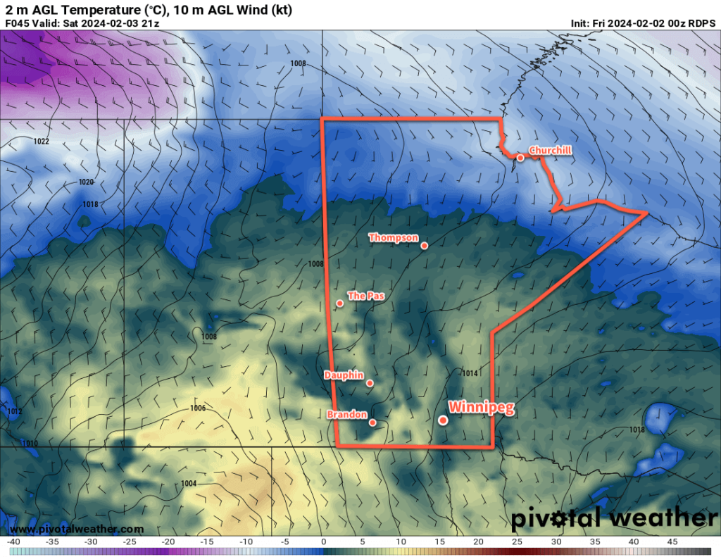
RDPS 2m Temperature Forecast valid 21Z Saturday February 3, 2024
Above-normal temperatures will be in place over the Prairies for another weekend.

An upper ridge continues to dominate the Prairies, bringing a Spring-like pattern to the region. Mild weather continues across the entire region with daytime highs over 10 °C above seasonal values.

Highs in Winnipeg will continue to reach 2 to 5 °C over the next few days. Breezy southerly winds will develop today, strengthening to 30 gusting 50 km/h, that will begin to ease in the evening. Overnight lows will dip into the -5 to 0 °C range.

With the warm weather, fog may be an issue each night as the melt is caught under a strong inversion.

Skies will start with plenty of sunshine today, but could cloud over this afternoon if an area of low cloud in Minnesota reaches far enough westwards as it pivots northwards into Canada. Heading further into the weekend, skies will trend cloudier as a weak low pressure system begins to track eastwards across the Prairies.

Little precipitation is expected for the area this weekend, but there could be light drizzle or flurries across the region on Sunday as the low moves into the area.

Long Range Outlook

Next week, cloudier conditions will develop for Winnipeg as a low pressure system crosses the province. In its wake, temperatures will cool below freezing but stay well above seasonal values.

Long-range forecast models show indications that a Colorado Low could impact the region by the end of the week. The more reliable long-range models have it more progressive and keep its impacts south and east of Manitoba, but sometimes weather models under-develop the upper troughs associated with these systems and they can end up slower and further west than initially forecast. That said, more moisture wouldn’t be a terrible thing for southern Manitoba at this point.

We hope you can get out and enjoy the pleasant weather this weekend! We’ll see you back here next week.

Today’s seasonal daytime high in Winnipeg is -11 °C while the seasonal overnight low is -21 °C.

Mild Week Ahead for Winnipeg

Temperatures will stay well above normal values this week as mild Pacific air continues to wash over southern Manitoba.

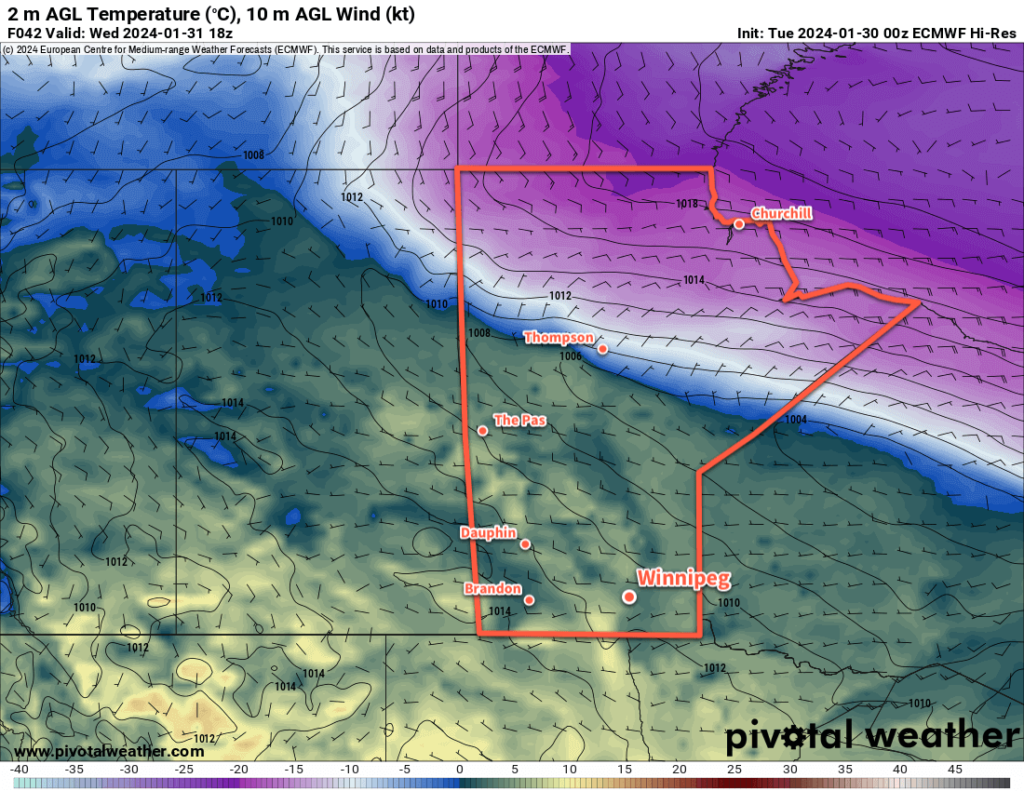
ECMWF 2m Temperature Forecast valid 18Z Wednesday January 31, 2024
Mild Pacific air will bring above-seasonal temperatures to most of the Canadian Prairies this week.

Persistent upper ridging over western Canada will keep a steady stream of milder air from the Pacific flowing over the region this week. As a result, daytime highs in the mid-single digits will persist through the week, while overnight lows dip to, or a few degrees below, freezing.

Winnipeg will see variable cloudiness over the coming days, trending cloudier in the second half of the week. Breezy southerly winds will develop over the region today, but winds will then ease for the next couple days.

Notable with this warmth, Winnipeg will likely see dew point temperatures climb above freezing in the days ahead. This will help make a significant dent in the snow pack over the region; when dew point temperatures climb above freezing, the warmth can dramatically increase the amount of melt that can occur. As a result, not only will the snow situation across the city look different at the end of the week, fog will be a likely sight overnight and in the early mornings through the course of the week.

Long Range Outlook

Cloudier weather will move in for the weekend, but with that will come more warm weather with overnight lows that could even stay above freezing.

The warm weather will continue into next week.

Today’s seasonal daytime high in Winnipeg is -11 °C while the seasonal overnight low is -22 °C.