Elsewhere in Weather News: July 7th, 2012

Devastating Derecho Races Across US States

An extremely powerful storm raced across part of the Midwest and Atlantic region the night of Friday, June 29th and into Saturday, shutting down power to millions of people. The type of storm, called derecho (pronounced day-RAY-cho) is a severe thunderstorm that produces severe wind gusts –downbursts that can produce a large swath of damage in a short amount of time. In addition to the wind threat normally associated with this type of storm, the intense lightning also poses a great danger to residents.

Time lapse video of the derecho trekking across the Midwest and Atlantic states. (Source: NOAA/NASA)

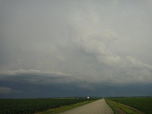
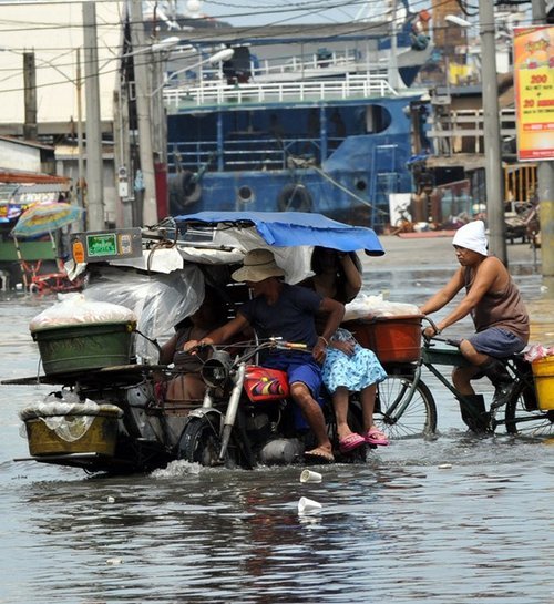
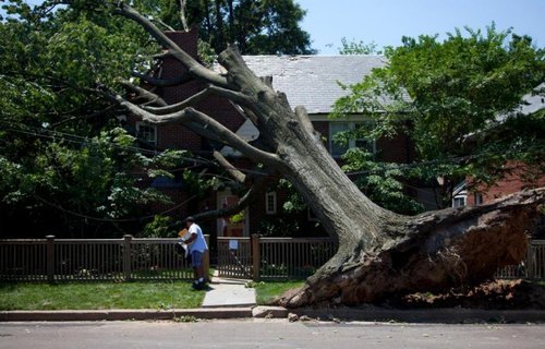
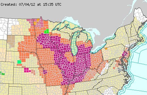
On this occasion, the derecho moved over 10 states and traveled for over 24 hours before reaching the Atlantic Ocean. Over three-and-a-half million people in the Midwest and Atlantic states were without power following the event. Boundless amounts of trees were uprooted, electrical poles taken down, and mobile homes that flipped, could be seen throughout the storm’s path. In all, 27 people lost their lives due to the storm. Hundreds of others were injured. In the storm’s aftermath, searing heat moved back into the region inciting more deaths as heat stroke became a major concern with no electricity to work with. As of Thursday night, July 5th, almost one week since the event passed through these states, there were still a quarter of a million people without power, mostly people north of Washington DC. Many cooling shelters had to be put in place across the area. Heat and humidity advisories were posted, urging residents to limit time spent outdoors to no more than a half-hour at a time. Some cities even cancelled July 4th celebrations due to power outages and excessive heat.

Wind damage

Just one of the many pictures taken of wind damage in the Washington, DC area, product of the derecho. (Source: Associated Press)

The tremendous heat and humidity is expected to stay in place throughout most of the eastern US where 3,000 temperature records were already broken this week, as of Thursday. There is a chance of relief from these extreme conditions next week, as a cold front is forecast to slice its way in a southerly motion through the Midwest and Atlantic states.

Heat warnings

Heat advisories in orange and excessive heat warnings in purple scattered across the Midwest and Atlantic states. On Friday the 6th of July, even a larger area was covered in warning and advisories. (Source: National Weather Service)

Powerful Storm Hits Bemidji

On Monday July 2nd, a few AWM team members headed down to Fargo to chase supercells. The targeted supercells quickly became a cluster of severe storms as they moved into Minnesota. Shortly afterwards, the cluster merged into a bow echo segment, which is very similar to a derecho but smaller in size. Locally, significant damage, similar to what was observed in the Midwest, was reported in Bemidji with the passing of this storm. One boater died as his vessel capsized due to the severe winds and torrential rains. Many trees over 100 years old and power lines snapped easily in the storm’s path, causing widespread power outages locally, in Central Minnesota. Because of all the damage and not much time to tend to downed power lines, the city issued a curfew to residents on Monday night from 11:00 pm to 6:00 am. The Storm Prediction Centre had warned of a bow echo in the days before the event, stressing the severe wind potential. Weather in Central Minnesota this weekend will be similar to Southern Manitoba’s, perhaps a little warmer.

Bemidji storm

Picture of the back side of the storm as it approaches Bemidji, taken north-east of Fargo in Minnesota. (Source: AWM chase team)

Elsewhere in Weather News: June 23rd, 2012

Typhoons and Hurricanes Spin Up in Northern Hemisphere

Mother Nature has been very busy world-wide, wreaking havoc of all forms this past week. The Deluth floods, tornadoes in South Dakota, and as reported in today’s EIWN post—typhoons and hurricanes have spun up in the North-West Pacific and North Atlantic basins.

This past Sunday, June 17th, typhoon Guchol (known as Butchoy by the Philippines) gave a scare to the Philippine islands’ residents as it scooted a couple hundred kilometers to the east of the islands while racing northwards. Minor storm surge and the outer spiral bands of Guchol brought heavy rains and flash floods to the area. Making matters worse was the fact that the monsoon winds were occurring, feeding warm, moist, air from the equator. The streets in Manila were flooded requiring people to walk through waist-high water to reach their destination. Landslides caused by the heavy rains were also reported in the region. The eye of the typhoon didn’t hit land in Manila however; it kept roaring in a northerly fashion towards Japan where it finally made landfall on Tuesday. Intense winds were recorded above 200km/h near the eye of the storm. Flash-flood conditions existed in areas where the typhoon made landfall and near the core, through the more mountainous regions of Japan. About 80 people had injuries relating to the storm and one person died when his house was torn apart by the vicious winds. Since then, Guchol has been downgraded to an extratropical storm and has weakened significantly as it’s path continues over land and it moves away from the warm sea surface temperatures that gave it it’s energy.

Manila flooding

Streets of Manila completely underwater. (Source: Ted Aljibe/RT)

Guchol

Image of Guchol racing towards Japan in the North-West Pacific Ocean. (Source: NASA)

Meanwhile, in the North Atlantic, the third-named storm of the year, Hurricane Chris, formed far off to the south-east of Newfoundland, in the middle of the North Atlantic but poses no threat to land. This hurricane is only the second most northerly hurricane in the history of record keeping. It managed to form in the 22°C waters of the North Atlantic Ocean, bringing us to wonder whether it developed due to global warming or is just a glimpse the planet’s extremes?

Later this weekend various models are hinting at a tropical storm forming in the southern half of the Gulf of Mexico. Other than that, models are in disagreement and all over the place regarding which way future “Debby” will be heading.

Debby

NAM’s projection of where Debby will be Sunday morning. (Source: TwisterData/AWM Model Viewer)

Elsewhere in Weather News: June 16th, 2012

Large Waterspout Makes Landfall in Venice

A large waterspout made landfall on the islands of Venice on Tuesday, June 12th. The tornado caused considerable damage on the islands but missed the picturesque city centre of Venice altogether. As the waterspout made landfall on Venice’s lagoon, it traveled towards the island of Saint’Erasmo and Certosa where there were numerous reports of trees being shredded and uprooted, roofs being torn off and the city’s well-known gondolas being thrashed around. Two significant structures that were reported as being damaged include a soccer stadium and a naval academy where a tree fell, trapping 15 students inside the building. Winds were estimated to be howling at a rate of about 145km/h inside the twister at the time it made landfall, classifying it as an EF-1 tornado under the Enhanced Fujita Scale. One man was injured and the damages are estimated to be near a couple of millions of dollars.

Venice waterspout

Picture of the waterspout/tornado as it makes landfall. (Source: Cristian Cavallarin)

Damage path

Damage on one of Venice’s islands. (Source: EPA)

Waterspouts in the region are usually associated with small spin-ups and pulse storms over a large body of water, which typically dissipate when making landfall. However, this waterspout in particular had not dissipated as it moved over the islands due to its unusual strength and cone-like shape – signifying strong rotation present. According to a satellite picture taken at the time, it appears a shortwave provided the necessary ingredients to spawn the tornado and lengthen the duration of the storms.

Satellite picture

Satellite picture on the morning of June 12th, 2012. Approximate location of Venice, Italy represented by the green dot on the map. (Source: EarthSky/CIMSS)

Even though tornadoes are not as common in Europe as they are in North America, Italy has seen its fair share of deadly tornadoes this past century. A couple of notable tornadoes are:

-The Montello tornado in 1930 – possibly the strongest tornado ever to touch down in Europe, it brought gusts of over 500km/h and completely levelled brick buildings.
-The Venice tornado outbreak of 1970 – which included a notable tornado that went through Venice causing deaths and destruction throughout the city.

View of the tornado from downtown Venice. (Source: The Telegraph)

Storms were reported to have cleared out of Venice’s region near the end of this week. The weekend forecast in that area calls for light showers on Saturday and all-out sun on Sunday.

A couple other notable events that have happened in other parts of the world since last weekend include: a hurricane spinning up in the Eastern Pacific heading towards Mexico’s western coast; and significant flooding in Pensacola, Florida where over 540mm (more than a year’s worth of precipitation in Winnipeg, Manitoba) fell in 24 hours!

Elsewhere in Weather News: June 9th, 2012

Colorado and Wyoming Battered by Storm System

A low pressure system that has brought tornadoes, hail and large amounts of rain to the western half of the United States this week has caused significant damage in Colorado and Wyoming. The warm, moist, air rushing north from the Gulf of Mexico made for a volatile atmosphere Wednesday and Thursday afternoon as it clashed with the Rocky Mountain range.

Piles of hail

A woman walks where bulldozers piled up huge amounts of hail. This picture was even taken the morning following the storm! (Source: The Gazette)

On Wednesday, storms dumped huge amounts of rain and hail in many parts of Colorado and Wyoming, prompting the National Weather Service to issue flash flood warnings in areas where storm cells were nearly stationary. Colorado Springs had a very intense thunderstorm pass through it where over 20cm of hail fell in the area and snow plows had to be used to clear roads and parking lots. Fire and rescue were also kept busy, saving people from submerged cars that had water up to their roofs. On Thursday morning residents there were surprised to see what one man described as a “scene that you’d only see in the winter”. A little further north, on Wednesday, was where most of the tornadic action was happening. In total five tornadoes were sighted touching down in the northern tier of Colorado, however only minor damage occurred and thankfully no injuries were reported. One tornado, reported as a landspout, even scooted to the north of Denver’s international airport, causing a scare to many passengers, but no damage was done to aircraft.

Precipitation map - Colorado Springs

Map of the rain the fell (inches) in Colorado Springs, CO. (Source: CoCoRaHS)

The harsh weather didn’t end there however. On Thursday the 7th, another round struck the same area spawning more tornadoes, dropping huge hailstones and more significant rainfall. On Thursday the heaviest of the rain occurred in extreme northern Colorado and south-eastern Wyoming, where it was greatly appreciated to help combat a moderate drought and wildfires present in the region. In total, the SPC received another 10 tornado reports, some being more serious, ranging from roofs being blown off to windows being blown out. Only one non life-threatening injury was reported with that round of tornadoes thanks to the great work of the National Weather Service who provided early warning.

Wyoming tornado

A large funnel 100km north of Cheyenne, WY. (Source: Andrew Kniss)

As the trough spawning the severe weather shifts west, the region will experience cooler weather, thus, giving way to a stable atmosphere and calmer weather.

This system that that the western half of the United States experienced this week is expected to spawn severe thunderstorms in North Dakota and in southern Manitoba today.