Rain on Monday, Nice Midweek

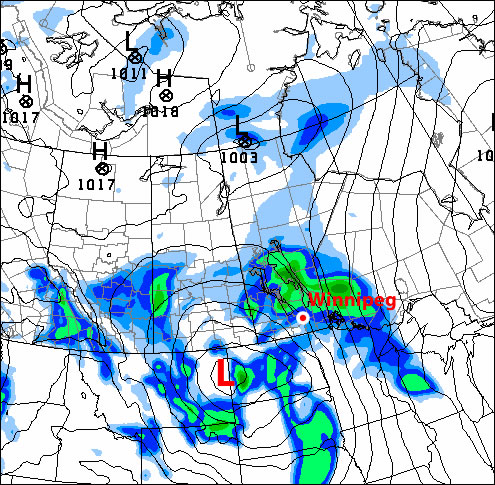
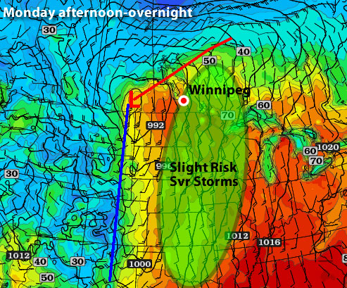
Another weak weather system is in store to start the week. A bit of rain is in the forecast for Monday, but conditions will improve rapidly toward midweek.

Surface map for Monday

HPC’s surface map for Monday showing the location of the cold front

A low pressure system and its associated cold front will generate some light rain over South-Central and Eastern Manitoba on Monday. Accumulations will generally be around 5mm in the Red River Valley and South-Eastern Manitoba. Some areas near the Ontario border may see amounts closer to 10mm. There is a small chance that some thunderstorms may become embedded within the area of rain. Any areas that experience weak thunderstorm activity may see slightly higher rainfall amounts.

Since a cold front will be passing through on Monday temperatures will be cooler than on the weekend. Highs in the Red River Valley and South-Eastern Manitoba will be around 10 degrees. Some areas will be slightly warmer or colder than that mark depending on when the rain starts and how quickly the cold front goes through.

The middle of the week is looking good. Tuesday should be a very nice day with highs in the mid teens and relatively light wind speeds. High temperatures on Wednesday should be in the high teens or near twenty degrees. On Thursday we will have a shot at twenty degrees yet again.

Low pressure system forecast to impact Southern Manitoba next weekend

Low pressure system forecast to impact Southern Manitoba next weekend – image courtesy of College of Dupage

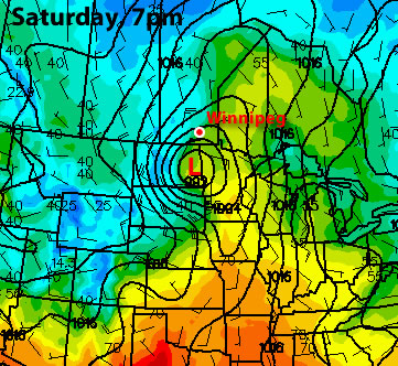
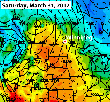
Unfortunately, conditions are forecast to turn unsettled for the weekend. Current models show a strong low pressure system impacting Southern Manitoba on Saturday and Sunday. Should this system pan out, which is never a certainty, it could be both a rain and snow producer. It is too early to get into any further detail, but this potential storm bears watching.

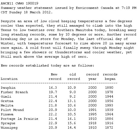
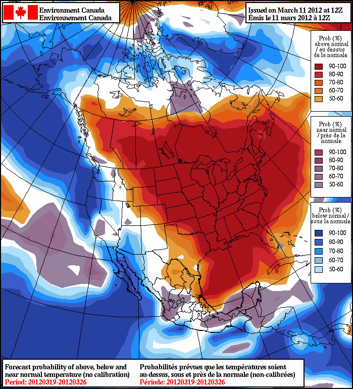
March 2012 was the warmest March on record in Winnipeg since records began in 1872. The month ended up with a mean temperature of +2.2C, which is 8.3 degrees warmer than normal (-6.1C). Prior to this year Winnipeg’s warmest March on record was the March of 1878, with a mean temperature of +1.6C. Below is a recap of the many records broken last month:

  • 8 daily record high temperatures (11, 12, 15, 16, 17, 18, 19, 22)
  • Earliest 20°C reading on record (March 18)
  • Warmest overnight low in March (14°C on the night of March 18/19)
  • Earliest thunderstorm on record since 1953 (Evening of March 19th)
  • Warmest March day on record (March 19th, 23.7°C)
  • Most significant departure from normal temperature for any day of the year (+23.4°C above normal on March 19th)
  • 4 consecutive days over 19°C (Only 4 days since records began have reached that mark. From Rob’s Blog: In other words, it took only 4 days during this warm spell to match what took 140 years to accomplish.)
  • Warmest March on Record (Mean temperature of 2.2°C, beating the previous record of 1.6°C set in 1878).
  • Highest dew point in March (17°C on March 19th, need to finish parsing data set to verify)

Elsewhere in Weather News

Rare, Large Mexican Landspout Touches Down

On the outskirts of the city of Nuevo-Laredo, Mexico, located near the Texan border, an unusual sight could be seen on Thursday, March the 29th. An abnormally large landspout touched down for an extended period of time, picking up dust, trees, shrubs and flipping over a trailer on the highway. In this case, thankfully no one was injured but landspouts are often underestimated and can create as much damage as a tornado, over a smaller area.

Landspout crossing the highway on the outskirts of Nuevo-Laredo on Thursday March 29th. (Source: Melissa Estrada)

Landspout crossing the highway on the outskirts of Nuevo-Laredo on Thursday March 29th. (Source: Melissa Estrada)

The landspout is of the same family as a tornado however they have different characteristics than a tornado, which is typically spawned by a supercell. Landspouts usually spin up under towering cumulus or non-supercellular storms, as the updraft catches the rotation at ground level. This is different compared to a tornado, which starts from the base of a supercell as a funnel and proceeds to drop until it reaches the ground and becomes a tornado. The speed inside this rotating column of air (landspout) increases as the column is stretched out and can possibly become as damaging as a tornado.

The severe, elevated storm also brought with it some hail the size of tennis balls that accompanied the landspout. No other damage other than the flipped trailer was reported as the landspout moved into unpopulated areas of the Mexican plains.

Elsewhere in Weather News has been provided by Matt

Our First Spring Storm System

After a period of unprecedented March warmth, it is time for a dose of March weather reality. Our first significant spring weather system will roll through Southern Manitoba early this week. This system will follow what has been a cool, but fairly seasonal weekend. Hopefully you are starting to get a feel for what spring is really like in Southern Manitoba.

Precipitation forecast for Southern Manitoba early on Tuesday morning

The GEM model shows light rainfall over Southern Manitoba at 1am on Tuesday with more precipitation developing over the Dakotas

A strong south-easterly wind will develop out ahead of the approaching low pressure system on Monday. Wind speeds will generally be on the order of 40km/h gusting to 60km/h. The combination of strong wind speeds and mainly cloudy skies will mean that high temperatures in Southern Manitoba will stay stuck in the mid single digits on Monday. During the day on Monday light shower activity, as well as the odd embedded thunderstorm, will develop across Southern Manitoba. Accumulations from these showers are expected to be light, with rainfall amounts of only a couple millimeters expected.

This weather system will really begin to get going on Monday night, with strong to severe thunderstorms expected to develop across the Dakotas. These thunderstorms will be triggered by a strong area of lift associated with the low pressure system. Additionally, a powerful low-level jet stream will provide a secondary source of lifting and a strong moisture feed. A low-level jet stream, or LLJ for short, is a “river” of very strong wind about 5000 feet above the ground. Wind speeds in the LLJ can exceed 100km/h less than one mile above the surface. The result of the LLJ on Monday night will be the rapid movement of air into the Northern US Plains and Southern Manitoba from more southern parts of the United States. The movement of warmer, more moist air into our region along the LLJ will provide support for some stronger storms on Monday night. The potential for severe thunderstorms certainly exists on Monday night in portions of North and South Dakota. It is unlikely that we’ll see any severe storms in Manitoba, but some stronger cells with gusty winds and hail may sneak across the border late on Monday or early on Tuesday.

The thunderstorms that develop across the Dakotas on Monday night will eventually move into Southern Manitoba during the overnight hours regardless of their strength. Besides the potential for gusty winds and hail as outlined above, many of the storms moving up from the south will produce locally heavy rainfall. Widespread accumulations of 5 to 10mm are expected on Monday night into Tuesday morning over Southern Manitoba, but locally heavier amounts are possible where thunderstorms pass by.

The bulk of the precipitation will be over for Winnipeg and the Red River Valley by Tuesday morning. Only light showers will persist during the day on Tuesday. However, residents of Western Manitoba won’t be quite as lucky. Rain will change to snow in Western Manitoba on Tuesday morning. Snow will continue over portions of Western Manitoba through the day on Tuesday. Total accumulations by Tuesday evening will generally be in the 2 to 6cm range in Western Manitoba. However, areas at higher elevations, such as Riding Mountain National Park, may see 10cm or more by late in the day on Tuesday. It is possible that Winnipeg and the Red River Valley could get a bit of snow on Tuesday evening. If any snow does fall it will be light in nature and won’t accumulate to much, if anything. Even if Winnipeg does get a dusting of light snow on Tuesday night it will be gone by Wednesday, as high temperatures will remain well above zero through mid-week.

Storm total rainfall amounts in Southern Manitoba will vary from place to place. Some estimates are listed below:

  • Winnipeg: 10 to 15mm
  • Steinbach: 5 to 10mm
  • Brandon: 10 to 20mm
  • Portage la Prairie: 10 to 15mm

*Note that the above forecasts have a large margin of error given that thunderstorms will largely determine where the heaviest rain will fall.

The GFS is predicting temperatures near 20C for Winnipeg next Saturday

The GFS model temperature prediction for next Saturday – the yellow/orange boundary represents temperatures near 20C (image courtesy of College of Dupage)

Long-range models don’t show any sign of winter returning to Southern Manitoba. The current run of the GFS model (a short to medium range model) shows temperatures potentially returning to the 20C mark in Southern Manitoba by next weekend. While this may or may not actually happen, it is a sure sign that temperatures will remain above-normal through the end of the month.


Elsewhere in Weather News

Hail Storm – A Winter Wonderland

This past Friday, a severe thunderstorm rolled through Indiana bringing with it strong winds, heavy rain and frequent lightning. What was so unusual about this storm was that it also dumped four inches of hail during the course of 15 minutes – which is considered quite a lengthy time for a hail storm. The severity of the hail storm was more than enough to wreak havoc on the highways. Hail drifts were reported to be a foot high in some areas and authorities closed a section of the interstate in the area due to cars getting stuck in ruts and several accidents being reported. The road conditions were winter-like as cars hit the ditch and residents described the scenery as a “hail blizzard”. After four hours, snow plows cleared away the remainder of the hail that was not melted yet and the interstate was reopened. The hail was not significant in size as it came down, only measuring up to dime-size, causing no property damage in the area.

Hail drift in the doorway, taken in Fountaintown, IN (just east of Indianapolis). (Source: WTHR news - Jessica White)

Hail drift in the doorway, taken in Fountaintown, IN (just east of Indianapolis). (Source: WTHR news – Jessica White)

The line of storms that was associated with a cold front moving through the region also prompted tornado watches in the Midwest, as several weak tornadoes touched down in Illinois, Indiana and Kentucky. Since then, the slow moving cut-off low brought more potent storms to the Southeast US on Saturday. It has now moved out over the Atlantic and is no longer a threat to North America.

Interstate 74 totally covered by hail, with ruts. Snowplows had to come in and clear away the hail. (Source: WTHR news)

Interstate 74 totally covered by hail, with ruts. Snowplows had to come in and clear away the hail. (Source: WTHR news)

Elsewhere in Weather News has been provided by Matt

March Madness

What a week it has been! Temperature records have fallen, our snow cover has disappeared, and thunderstorms are in the forecast – the question is what next?

Map showing the risk of thunderstorms on Monday, March 19, 2012

The light green region shows where there is a slight risk for severe thunderstorms on Monday

This week will start out on a warm and possibly stormy note. Monday’s temperatures are expected to be in the low to mid twenties across Southern Manitoba with a risk of thunderstorms. If Winnipeg records a high temperature on Monday that is greater than +23.3C the city will record a new all-time record high for the month of March. The previous all-time record high of +23.3C was set on March 27, 1946. On Sunday Winnipeg set a new record for the earliest ever occurence of a 20C high temperature, beating the old record of +22.8C set on March 23, 1910.

Day New
Record
Old
Record
Previous
Record Year
Sun Mar. 11 12.8°C 12.5°C 1981
Mon Mar. 12 9.7°C 7.2°C 1922
Thurs Mar. 15 14.4°C 11.1°C 1927
Fri Mar. 16 19.9°C 12.4°C 1981
Sat Mar. 17 19.2°C 12.8°C 1938
Sun Mar. 18 20.9°C 14.4°C 1910
Mon Mar. 19 23.7°C 18.9°C 1938
Table of daily record high temperatures over the past week.

As you may have noticed on Sunday, the humidity has risen significantly in the Red River Valley and South-Eastern Manitoba. When that extra moisture in the air is combined with warm temperatures, thunderstorms become possible. A strong jet stream is currently in place over Southern Manitoba, setting the stage for some potentially strong storms later on Monday afternoon into the evening. There will be a “lid*” over the atmosphere on Monday preventing storms from developing earlier in the day. This “lid” may or may not come off the atmosphere later on Monday. Whether or not the “lid” comes off will determine if storms can develop. Any storms that form shouldn’t be particularly strong, with the strongest storms only being marginally severe at best. However, with the way this March has gone it is best to assume that anything can happen – including stronger than expected thunderstorms.

The rest of the week looks a bit more “normal”. Actually temperatures will remain well above-normal but will seem more reasonable for this time of year. It looks like most days this week should feature high temperatures in the low double digits. As a result more temperature records will be threatened over the coming days, but they won’t be broken by the huge margins seen on the weekend. It doesn’t look like any more 20C days are imminent, but we certainly could hit 20 degrees again before the month is over.

In the long range models show continued warm weather through the end of March. With our snow cover gone it will be very difficult for conditions in Southern Manitoba to reach below-normal values. We’ll have to wait until our seasonal averages rise by several degrees before below-normal weather is even possible again. Bear in mind that above-normal temperatures don’t necessarily give way to beautiful weather conditions all the time. Models do hint at less settled weather over the next 7-10 days, which means we could get our first significant rain storm of the season (fingers crossed that it doesn’t turn into a snowstorm!)

Here is Environment Canada’s statement regarding broken temperature records on Sunday:

March 18, 2012 High Temperature Records

New high temperature records set on March 18, 2012

*A “lid” being on the atmosphere is simple way of referring to atmospheric capping. Capping is when there is warm air above the ground which prevents air near the surface from rising. We know that warm air rises and cold air sinks, but warm air only rises if it is warmer than the air around it. Therefore if the air at the surface is relatively warmer than the air aloft it will rise and if the air aloft is relatively warmer than the air at the surface the surface air won’t rise. On Monday the air aloft will be relatively warmer than the air at the surface for most of the day. Storms will only develop if colder air moves in aloft allowing the surface air to rise up high into the atmosphere. This may or may not happen, causing the thunderstorm forecast to remain uncertain.


Elsewhere in Weather News

Record Breaking Heat Wave Across the United States

The heat wave that currently has Southern Manitoba feeling more like May than March has also taken hold of much of the United States this past week. The unusual warmth is caused by a large surge in the jet stream over most of the US Plains, Midwest and East Coast. The jet stream, which acts as a fence between the cold air masses and warm air masses, is part of the reason why the US is experiencing its first major heat wave of the year. As the jet stream surges in the Plains and East, a trough (dip) in the jet stream over the west coast is bringing unseasonably cold air to the region and much precipitation with it.

250mb wind speeds, showing the jet stream, Sunday March 18th. (Source: Brad’s Model Viewer/COD)

250mb wind speeds, showing the jet stream, Sunday March 18th. (Source: Brad’s Model Viewer/COD)

Since the beginning of March the US has seen more than 1700 new records reached, including some records that weren’t even close to the previous records. Here are some notable ones from this past week across the US:

  • International Falls, MN: Previous record = 13°C, New record = 25°C, Average = 1°C
  • Marquette, MI: Previous record = 16°C, New record = 24°C, Average = 3°C
  • Minneapolis, MN: Previous record = 17°C, New record = 23°C, Average = 4°C

    Map showing record highs Wednesday, March 14th. 307 record highs were broken and 97 tied. (Source: National Climactic Data Center)

Map showing record highs Wednesday, March 14th. 307 record highs were broken and 97 tied. (Source: National Climactic Data Center)

As the jet stream shifts east early this week the spell of record-breaking temperatures will end for the plains, giving way to strong thunderstorms as the cool air from the west collides with the moist gulf air present over tornado alley. However, the Midwest and East Coast will remain near record breaking temperatures for a couple more days before cooler air arrives (but still above normal) and ushers showers in with it.

Spring Continues

The wonderful weather experienced on the weekend will continue into this week. Temperatures are expected to remain well above normal for the foreseeable future.

The NAEFS long-range forecast shows above-normal weather across much of North America

The NAEFS long-range forecast shows above-normal weather for Manitoba through mid to late March

Figuring out just how warm it will get this week is a challenge. There is snow in some parts of Southern Manitoba and bare ground in other parts. Areas that are snow-free will be warmer than those regions that still have snow. Weather models haven’t handled temperature forecasts very well lately, making forecasting even more difficult. Based on the warm temperatures experienced this weekend it appears that most days this week will have high temperatures in the high single digits or low double digits. Toward the end of the week we may have a shot at mid to high double-digit temperatures if most of the snow has disappeared as expected. Due to all the melting snow this week fog will be possible on most days. The additional water vapour that is added to the air due to the snow melt provides the necessary ingredient for dense fog patches to develop. Luckily with the sun becoming increasingly strong most areas of fog should dissipate fairly quick after the sun comes out.

A number of records were broken over the weekend due to the usually warm temperatures that occured. More daily high temperature records will likely be broken almost every day this week as conditions remain warm.

In the longer range there is no sign of a colder pattern. Most forecasts show warm weather continuing for at least the next 10 days. However, bear in mind that Winnipeg averages 10cm of snow in April, so don’t count on completely smooth sailing into summer.


Elsewhere in Weather News

Waterspout Makes Landfall in Hawaii

As Hawaii nears the end of its rainy season, very strong thunderstorms producing tornadoes over the Pacific Ocean made landfall on the islands this week, producing the first tornado to hit Hawaii in four years. On the morning of Friday March 9th, the tornado struck Kailua, one of the suburbs of Honolulu. From there, it moved inland for a mile-and-a-half before dissipating. There were no injuries associated with the tornado and only minor structural damage to a couple houses, where parts of roofs were torn off and windows damaged. Storm surveyors estimated the tornado to be an EF-0, with winds of 96km/h to 112km/h.

Photo Alt Text

The waterspout that made landfall caused significant damage to this house. (Source: Craig T.Kojima)

What was even more unusual to Hawaii with these thunderstorms is that they brought very large hailstones to the area, which is unheard of on the islands. The 30 minute hailstorm was described by Tom Birchard, a senior meteorologist at the National Weather Service (NWS) of Honolulu, as “unprecedented” and mentioned the three-inch hailstones are “likely record-breaking”.

Photo Alt Text

Small stream turned into raging river because of heavy rains in Hawaii. (Source: County of Maui.)

With the thunderstorms being nearly stationary and rain rates reaching over 75mm/h during the course of the day, mudslides prompted officials to close the roads. Schools were also closed and flights cancelled out of Kauai because of the heavy rains.

Thankfully Hawaii’s stormy weather is forecast to clear this upcoming week with partly cloudy skies and steady temperatures of 25°C. The high pressure that created a blocking pattern will move off, allowing the low pressure system to leave Hawaii.

Elsewhere in Weather News has been provided by Matt