Warmer Weather is on its Way

With spring set to officially begin in just a few weeks it appears that spring-like weather is not far off either. It is safe to say that winter’s worst cold is behind us.

GEM Model precipitation forecast for Tuesday morning

GEM-Regional model precipitation forecast for early Tuesday morning

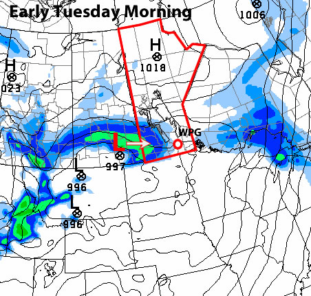
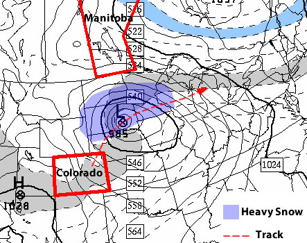
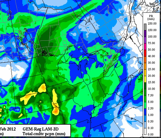
For the most part this week is expected to be warm in Southern Manitoba, but with some snow. Two low pressure systems will move across Southern Manitoba early in the week. One low will pass through on Monday and another one on Tuesday. The first system will be very weak and will drop less than 2cm of snow in most of Southern Manitoba on Monday. The second system on Monday night into Tuesday will be stronger, but the majority of the snow is expected to pass through Western Manitoba and up into the Interlake, avoiding the more heavily populated parts of Manitoba. However, the Tuesday system may still generate amounts of 2-4cm in places like Winnipeg and Brandon if it tracks as currently expected. Parts of Southern Manitoba closer to the International border can expect to see 2cm of snow or less from Monday night through Tuesday. Despite the fact that Monday and Tuesday will be a bit snowy temperatures will remain quite mild. Highs on both days should be near the zero mark in most areas. As Tuesday’s weather system departs it will pull down a bit of colder air from the north. As such expect a northerly wind to develop later on Tuesday causing temperatures to drop off for Tuesday night and Wednesday.

The second half of the week also looks to be rather mild. As alluded to earlier, Wednesday will be the coolest day of the week as we deal with the minor push of cold air caused by the low pressure system on Tuesday. By Thursday and Friday temperatures are expected to rise back to or above zero degrees, hopefully melting some of the snow that accumulated earlier in the week.

Climate Prediction Center outlook for March 10-14. Red areas can expect above-normal temperatures

Climate Prediction Center outlook for March 10-14. Red areas can expect above-normal temperatures

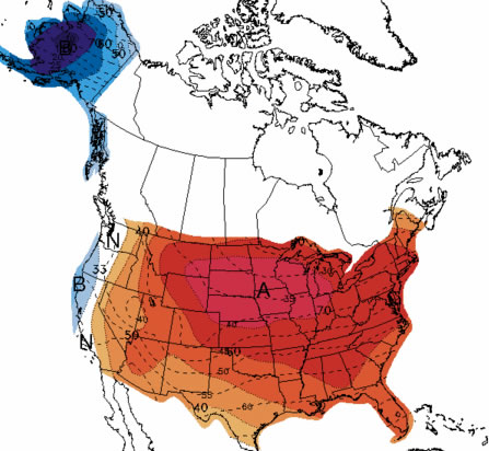
In the medium-range weather models are showing above-normal weather conditions (temperatures) developing in Southern Manitoba. If you read last week’s Monday post you will have realized that the long-range forecast for March was a bit unclear. In more recent days many medium range models and forecasts have begun to reveal the potential for warm conditions through early to mid March. The Climate Prediction Center graphic above illustrates this trend. However, we still don’t have a good understanding of how March will end. Although if you believe in the old March sayings “In like a lamb, out like a lion” or “In like a lion, out like a lamb” this March should end very nicely considering the nasty snowstorm late last week.


A Deadly Week in the US: Damaging Tornadoes

Tornado Outbreak: February 28 – 29, 2012

Disastrous cold fronts associated with low pressure systems barreled through many parts the United States last week. Areas that were hit the hardest include the Midwest, the Appalachian region, the Southeast and Southern Plains causing widespread destruction and over 50 deaths. As the system emerged from the Rockies, the cold front brought the necessary trigger to lift the moist, warm air. Early on, the Southern Plains were impacted with cold-core tornadoes in Nebraska and stronger storms throughout eastern Kansas where multiple weak tornadoes were reported, as well as an EF-2 tornado that destroyed most of the town of Harveyville, Kansas. Thankfully everyone was accounted for and only injuries were reported with the Harveyville twister.

Harrisburg, Ill – A man inspects what is left of a house completely demolished by the EF-4 tornado. (Source: ABC 7)

Harrisburg, Ill – A man inspects what is left of a house completely demolished by the EF-4 tornado. (Source: ABC 7)

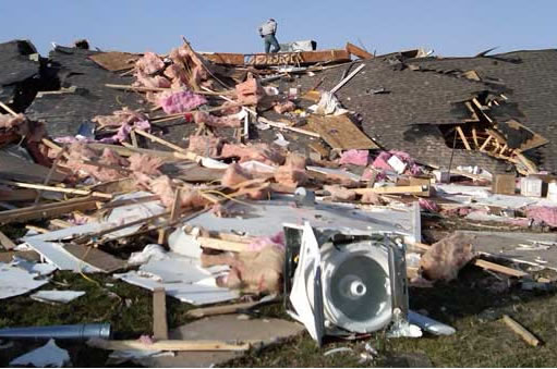
As the cold front continued to push east into the night of Tuesday, February 28th, it spawned more dangerous tornadoes throughout Missouri and in southern Illinois. The strongest tornado produced, rated EF-4, struck the town of Harrisburg, Illinois, killing nine people and destroying entire city blocks at one time. As the cold front pushed east, even more tornadoes spun up through Kentucky and Tennessee on the 29th, injuring more people in the towns of Clarkson and Hodgenville, Kentucky. The two day ordeal brought in about 300 wind damage reports and over 50 tornado reports, spanning over nine states.

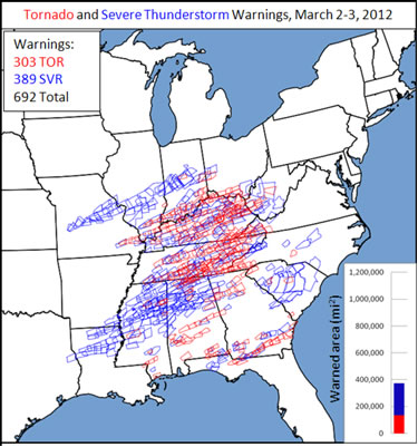
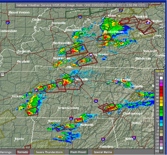
Tornado Outbreak: March 2 – 3, 2012

The destruction did not end there however. Another low pressure system had moved over Michigan – it spanned from southern Ontario all the way down to eastern Texas. The best parameters for severe storms were situated in the Midwest, around the western foothills of the Appalachians and through the US Southeast. The Storm Prediction Center (SPC) had issued some of these areas as ‘high risk’ for Friday, March 2nd – the highest tier of risk for severe weather the SPC can issue.

US Southeast RADAR showing the system spanning from southern Ontario to Texas at 3:30pm, March 2nd, including many supercells along and ahead of the cold front. (Source: College of DuPage)

US Southeast RADAR showing the system spanning from southern Ontario to Texas at 3:30pm, March 2nd, including many supercells along and ahead of the cold front. (Source: College of DuPage)

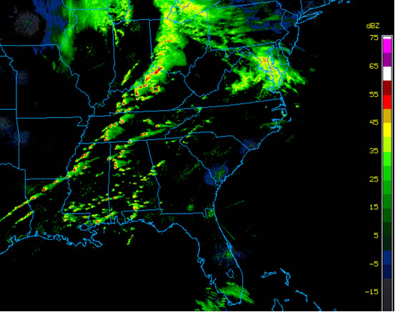
Supercells were popping up all over RADARs as the afternoon wore on, and the ingredients were in place for long-tracked tornadoes. Many tornadoes ripped through towns on this day, including West Liberty, Kentucky (pop. 3000), where the town was levelled by an EF-3 – not one building left untouched.

Warnings issued by the SPC March 2nd through 3rd. (Source: SPC)

Warnings issued by the SPC March 2nd through 3rd. (Source: SPC)

Some of the hardest hit areas, Kentucky and Tennessee, were expecting freezing rain following the cold front.

Nashville RADAR, including 11 tornado warnings, showing many supercells on the afternoon of March 2nd. (Source: NOAA-NWS)

Nashville RADAR, including 11 tornado warnings, showing many supercells on the afternoon of March 2nd. (Source: NOAA-NWS)

Here are some storm statistics regarding the outbreak:

  • A storm near Wilmore, Kentucky, was moving at speeds up to 137km/h.
  • 39 people, across five states, died from tornadoes associated with this storm – over 300 injured in Kentucky alone.
  • Winds up to 280km/h accompanied the Henryville, Indiana, tornado (EF-4) and the tornado stayed on the ground for over 80km.
  • At one point, four million people were within 40km of a tornado.
  • Three states issued a state of emergency.

Elsewhere in Weather News has been provided by Matt

Calmer Weather On Tap (for Manitoba)

After a wild week of weather that featured heavy snowfall across many parts of Southern Manitoba conditions will begin to calm down. However, the same can’t be said for areas just to our south.

Surface Map Showing the Colorado Low

Surface map showing the forecast track of the Colorado Low

A major winter storm will impact portions of the North-Central United States just south of Manitoba. Areas such as Fargo, North Dakota, Minneapolis, Minnesota, and Aberdeen, South Dakota will be impacted by a Colorado Low system on Tuesday and Wednesday of this week. The hardest hit areas in South Dakota and Central Minnesota may see upwards of 30cm (1 foot) of snow. Wind speeds will also be high during this storm and as such the National Weather Service has issued blizzard watches for portions of the Northern U.S. Plains. Anyone who has travel plans to regions just south of the border may want to reconsider as this will be a significant and potentially life-threatening winter storm.

On our side of the border the weather will be considerably different this week. Temperatures for the first half of the week will be very reasonable. Highs on Monday will be in the -10 to -15C range in most of Southern Manitoba, which is unseasonably cold. Fortunately wind speeds will be light on Monday, making conditions fairly comfortable. By Tuesday and Wednesday temperatures will have increased with highs in most of Southern Manitoba reaching the minus single digits. Temperatures for the remainder of the week will remain mild as an approaching low pressure system develops a southerly flow over Southern Manitoba. The approaching low pressure system will probably reach Southern Manitoba on Friday, potentially bringing a bit of light snow along with it.

With meteorological winter nearly over many people are wondering what March has in store. Unfortunately, there is no clear signal as to how March will evolve at this time. Most models show generally seasonable conditions in Southern Manitoba for the first part of March with no signs of any major warm-ups or cool-downs. Nevertheless, with spring set to begin in just over 3 weeks you can certainly count on the fact that winter’s worst cold is behind us.

Meteorological winter is defined as December, January, and February. Solar (calendar) winter lags behind by about 3 weeks (December 21 – March 21). Meteorological seasons more accurately describe the type of weather that takes place in Southern Manitoba


Elsewhere in Weather News

Flash Flooding in Queensland, Australia

The southeast region of Queensland, Australia experienced flooding this week after more than 330mm of rain fell in some areas. Although heavy rainfalls are not that uncommon in the region, southeast Queensland was deluged with heavy rain the past couple weeks and the river system levels are quite high.

This week’s rainfall totals for Queensland, some areas topping 300mm in one week! (Source: Bureau of Meterology, Australia)

This week’s rainfall totals for Queensland, some areas topping 300mm in one week! (Source: Bureau of Meterology, Australia)

From Friday, February 24th to Saturday the 25th, a surface trough combined with an upper-level low intensifying over Queensland and slowly moving westward, caused the Bureau of Meteorology (BoM) to issue multiple warnings. (In the southern hemisphere low pressure systems spin clockwise and move westward as opposed to the northern hemisphere where lows spins counter-clockwise and generally move eastward.) The BoM had issued flash flood warnings, advising that some of the downpours could easily reach 150-200mm within a day. Severe weather bulletins had also been issued for storms associated with this system however the main threat was flash flooding.

Bridge leading into Cooroy has been destroyed by rising waters. (Source: The Courier-Mail)

Bridge leading into Cooroy has been destroyed by rising waters. (Source: The Courier-Mail)

The rainfall caused extensive damage to the road networks in the region, causing authorities to close more than 40 roads and urge residents to stay off roads and only travel for urgent reasons. More than 100 water rescues were made due to rapidly rising water levels and fast flowing streams turning into raging rivers in a matter of minutes. The town of Cooroy which had been impacted by very strong winds earlier in the week had now been cut off by rising waters as the roads heading in and out of town were flooded out. Since then, the water has receded and the town can now travel freely.

The weather should clear up though, as the forecast calls for minimal rain for the start of the work week, with only sporadic showers occurring every second day.

Elsewhere in Weather News has been provided by Matt

Snow to Start the Week

A Colorado Low system will bring the potential for snow over parts of the Red River Valley and South-Eastern Manitoba on Monday and Monday night. This will not be a particularly potent Colorado Low, but it could cause problems nonetheless.

The Colorado Low (red L) at 6pm on Monday

The Colorado Low (red L) and its predicted track – Image valid on Monday, February 20, 2012 at 6pm

On Monday the Colorado Low system will be slowly moving north from the Central United States. The main low pressure centre will be located near the Nebraska/Kansas border around the noon hour and stall out over that region for the rest of the day. Meanwhile a secondary low pressure centre will be developing over Southern Manitoba or Northern North Dakota. This secondary low pressure centre will proceed to absorb the more Southern low centre on Monday night, creating one low near the Lake of the Woods by early Tuesday morning. Snow will begin in Southern Manitoba on Monday afternoon and the heaviest bands will exit the region on Monday night. Some light wrap-around snow may linger into Tuesday.

GEM-Regional's QPF outlook

Forecast snowfall accumulations by the GEM-Regional model. For simplicity assume the numbers along the side correspond to snowfall amounts in centimetres

All that information is nice, but that main question for most people is “how much snow will we get”. This is where things get tricky. Some models (such as the GEM-Regional above) are suggesting that South-Eastern Manitoba, including Steinbach, Sprague, and the Whiteshell will get upwards of 10cm of snow. This same model is predicting somewhere around 5 to 10cm for Winnipeg. As you can see in the graphic above, there will be a sharp cut-off in snowfall amounts to our west. This means that areas such as Portage, Morden and Carman will probably see no more than 2cm, if that. The fact that there will be a sharp cut-off in snowfall accumulations makes predicting amounts for given cities very difficult. If the cut-off line moves a little bit further west, then Steinbach and Winnipeg may see 10cm of snow. However, if the cut-off line moves a little further east, then Winnipeg may see very little if any snow, while Steinbach and the Eastern Red River Valley only get a few centimetres. Other models have completely different ideas for snowfall amounts with this system, so don’t assume that the GEM-Regional is correct (in fact we never assume that models are correct!).

Now that I’ve given you the background information on this snowfall event, I will provide my personal predictions. As I have alluded to above, there is still lots of uncertainty in snowfall predictions and as such the below forecasts are simply my best “guesses” given the information available.

  • Winnipeg: 2 to 4cm
  • Steinbach: 4 to 8cm
  • Portage: 0-2cm
  • Morden: 1-3cm
  • Whiteshell: 5 to 10cm, locally higher amounts near the Ontario border

Once we get through Monday, the weather will turn nice again. Tuesday and Wednesday will be warm with highs just below the zero mark in most parts of Southern Manitoba. Another low pressure system will be passing through our neck of the woods later in the week…but we’ll have more details on that later. Models are hinting at colder weather (i.e. below normal weather) for next weekend. Winter may not be done with us yet!


Elsewhere in Weather News

Giovanna – The Aftermath

Since reported last week, Giovanna, a cyclone in the western Indian Ocean with category 4 intensity at its peak, reached the central coast of Madagascar and caused considerable damage. The dangerous cyclone left 15 people dead and about 40,000 people homeless, most of them on the eastern coast where the cyclone made landfall and brought with it a significant storm surge and intense rainfall. Thankfully the capital city of Antananarivo (population 1.4 million) managed to avoid the center of the cyclone but the city still experienced widespread blackouts.

The track of Cyclone Giovanna

Super cyclone Giovanna’s complete track, added with its forecast track where it will eventually dissipate. (Source: HEWS)

Had the cyclone’s track had been slightly shifted to the north by about 40km, the damage would certainly have been greater in the capital. At its peak (over the western Indian Ocean before making landfall) the storm reached an astonishing 1,000 kilometres in diameter with sustained wind speeds estimated at about 230km/h.

Since heading back out into the Indian Ocean (Mozambique Channel), Giovanna’s track was more favourable to those in the region as it had taken a southerly track then turned easterly, not only avoiding a second landfall in Madagascar, but also completely avoiding Mozambique –the country that was ravaged by disastrous floods this year.

Elsewhere in the world, weather has been relatively quiet compared the last couple weeks. Some other weather news that could possibly make headlines this week is: another winter storm arriving in the UK this past Sunday, strong thunderstorms affecting the southern United States this past weekend, flooding in Peru and Brazil’s recent heat wave.

Pleasant Weather This Week

A fairly calm and uneventful week is in store weatherwise. Temperatures this week will be much warmer than the values experienced late last week.

NAM temperature forecast for Tuesday, February 14, 2012

NAM temperature forecast for the Prairies – valid Tuesday, February 14, 2012

Weather conditions for the first half of this week will be pleasant. High temperatures on Monday and Tuesday will generally remain in the -2 to -6C range in Southern Manitoba with light wind speeds. However, those parts of Southern Manitoba that are mostly snow-free will see temperatures around zero during this time period. The stronger February sun will heat these darker, snow-free areas more easily than white snow-covered regions resulting in warmer temperatures. Regions west of the Red River Valley and south of the Trans-Canada highway are the most snow-free parts of Manitoba and therefore will be noticeably warmer than areas around Winnipeg (that have more snow cover). By Wednesday it appears that all of Southern Manitoba will get up close to the 0C mark as a light southerly flow brings in some warmer air.

The weather outlook for the end of the week is just a little bit cooler from that of the beginning of the week. Temperatures on Thursday and Friday look to remain around or slightly warmer than seasonal values (normal high is -9C). Models are currently showing the potential for some light flurries on Friday into Saturday, but other than that it doesn’t look like we have any chance of seeing snow this week.

Seven weeks of winter down, six to go.


Elsewhere in Weather News

Super Cyclone Giovanna Threatens Madagascar

A very strong and dangerous cyclone named Giovanna has spun up in the western Indian Ocean this past Friday.

Super cyclone Giovanna marches towards Madagascar on IR satellite, with its predicted path. (Source: Sat24)

Super cyclone Giovanna marches towards Madagascar on IR satellite, with its predicted path. (Source: Sat24)

Giovanna is currently categorized as a category three cyclone (wind speeds of 160km/h) and is forecast to sustain its wind speed as it barrels towards the island of Madagascar. The combination of low wind shear and relatively warm waters of the western Indian Ocean is what has contributed to the rapid intensification of Giovanna. With the storm moving slowly towards the southwest, the landfall will take place on the Tuesday the 13th, bringing with it: torrential rains, a high storm surge and powerful sustained winds. The areas taking a direct hit with this cyclone will have a shot at receiving 250mm of rainfall (more than half of what Winnipeg receives yearly), wave heights reaching 24 feet and not to mention the sustained winds of about 190km/h. The storm may slowly intensify into category four, depending on whether or not an eyewall replacement cycle will occur before Giovanna makes landfall. This occurs when the cyclone’s thunderstorm bands circling around the eyewall use up some of the eyewall’s moisture and subsequently collapses the eyewall. Eventually, a new eyewall forms, strengthening the cyclone further and the cycle restarts.

Models predicting rain rates of above 45mm/h (red) as Giovanna approaches Madagascar (Source: Sat24)

Models predicting rain rates of above 45mm/h (red) as Giovanna approaches Madagascar (Source: Sat24)

The remnants of Giovanna will emerge into the Mozambique Channel and may re-intensify into a tropical storm. Unfortunately, this would bring heavy rains to Mozambique again, as they have already been plagued with torrential rains this season, more notably cyclone Funso (blogged about three weeks ago) which dumped significant rainfall on Mozambique’s coast not too long ago.

Elsewhere in Weather News has been provided by Matt