This week will be a warm one, with temperatures frequently reaching the upper twenties. This heat will be accompanied by some humidity, which will prompt a renewed risk of thunderstorms.
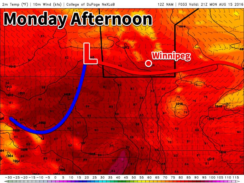
A warm front will be located in southern Manitoba today
This Week
Today will be a hot one in southern Manitoba. Temperatures will be in the upper twenties to near 30C, with increasing humidity making it feel more like the mid thirties. Winds will generally be light, with the direction varying between easterly and southerly depending on your location. The heat and humidity today will prompt a risk of thunderstorms. Some storms may be marginally severe, as moderate instability but weak wind shear characterizes the environment. Any severe storms could potentially produce hail around nickel size and wind gusts to 90 km/h – although the odd storm may slightly exceed those values. Storm coverage is not expected to be very widespread, so many people may not see any activity.
A weak cold front will pass through early Tuesday, cooling us down a little bit. High temperatures on Tuesday will generally be in the mid twenties, with some lingering humidity making it feel closer to 30. A risk of thunderstorms will once again be present due to that lingering humidity, but any storms that develop should be non-severe. Winds will be northerly at around 20 km/h.
Slightly warmer conditions are expected again for Wednesday as temperatures climb into the upper twenties with light southerly winds. Skies are expected to be mainly sunny, making for quite a nice day!
Long Range
The long range forecast shows a stronger cold front passing through southern Manitoba later this week, likely on Thursday or Friday. Depending on the timing of this front, it may pose another risk of thunderstorms. Following the frontal passage we’ll see somewhat cooler conditions, likely persisting into the weekend.
Cooler weather and scattered showers will settle into the Red River Valley today behind the low pressure system that brought multiple rounds of thunderstorm activity to Southern Manitoba over the past several days. The cool weather will give way to more seasonal warmth by the end of the weekend, but with the return of warmer weather will come another chance for thunderstorms in the first half of next week.
The weather in Winnipeg over the coming two days will be created by an upper-level low pressure system stalled out over east-central Manitoba. Both today and tomorrow will see fairly cloudy skies, likely mixed to mainly cloudy, alongside the chance for scattered showers. Today will present a better chance for showers than tomorrow, but even then the activity will likely be fairly light and scattered. Winds will be out of the west to northwest at around 20-30 km/h during the days and lighter at night. Daytime highs will be below-seasonal at just 21 or 22°C, however the overnight lows will be right on the mark for this time of year at 12 or 13°C.
Scattered showers are expected over southern Manitoba over the next two days.
The cloud should clear out on Saturday night as the upper low finally trundles out of the region and a ridge of high pressure builds in.
Sunday will be a comparatively pleasant day with mainly sunny skies, although the beginning and end of the day may be bookended by some clouds. Daytime highs in Winnipeg & the Red River Valley will be fairly warm at 26 or 27°C. With warmer air in place, the overnight low on Sunday night will also be milder at around 14 or 15°C.
Long Range
Early next week is looking mild, but the weather trend of 2016 continues with another chance for showers and thunderstorms returning sometime late Monday into Tuesday. At this point, it appears that this will appear as a round of thunderstorms on Monday night, but it’s still quite early and the timing of the system could easily change.
The long-term pattern continues to show an unsettled pattern with a couple days of showers and instability followed by a few days of drier weather. There are hints of attempts to produce more prolonged periods of dry weather in 1-3 weeks from now, but models seem to be struggling to establish the ridging required. So at this point, it looks like more of the same for the coming weeks, which is not likely the news that many farmers wish to hear heading towards harvest.
Winnipeg’s seasonal daytime high is currently 25°C while the seasonal overnight low is 12°C.
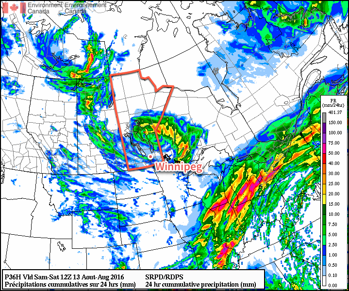
A slow-moving low pressure system that has meandered into the Prairies from the west coast will very gradually make its way through the province over the coming few days, bringing with it numerous chances for showers and thunderstorms.
The coming few days will be rather unsettled over the Red River Valley, however there’s no guarantee any one location will end up seeing all that much rainfall as multiple rounds of showers and thunderstorms swing across the region. Given that the next three days will all be under the influence of the same system, I’m going to break down the forecast in a slightly different way than usual and cover the weather elements individually instead of talking about each day.
Temperatures
Temperatures are expected to climb into the mid-20’s on Thursday in the Red River Valley.
First off, the temperatures. Today and Thursday will both be days with near-seasonal high temperatures of about 25°C. Overnight lows for today & tomorrow will be slightly warmer than normal with a lows of 16-17°C.
A cold front will sweep through on Thursday night, ushering in cooler temperatures for Friday with a daytime high near 22°C and an overnight low near 13°C.
Cloud Cover & Wind
Skies will become incrementally more cloudy over the next three days with a mix of sun and cloud expected today in Winnipeg, fairly cloudy skies with a few sunny breaks on Thursday, and mainly cloudy skies on Friday.
Winds will also be fairly light over the coming few days; expect easterly winds between 10-20 km/h today & tomorrow, then a shift to northwesterlies for Friday with slightly breezier conditions as winds climb to around 30 km/h.
Precipitation
This is the much harder thing to nail down in today’s forecast. The Red River Valley will be dealing with several waves of precipitation over several days, much of it convectively driven which automatically injects some uncertainty into the forecast. Here goes as best an overview as we can!
Variable amounts of rainfall are expected over the next 3 days in the Red River Valley with more confident rainfall amounts in Central Manitoba and North Dakota.
Wednesday: There will be a chance of showers or thunderstorms today as two areas of convection pass by to the south and north of the Red River Valley. Conditions will likely remain fairly dry, however there is the off chance of some areas being clipped by either of these systems. A more organized system will develop tonight as the frontal wave associated with the Pacific low moves through the region and the low itself moves in.
Wednesday Night/Thursday: A risk of elevated convection will be in place tonight into Thursday morning. There’s still uncertainty with exactly where the storms will develop, but it’s safe to say that the entire Red River Valley is at risk of seeing thunderstorms and rain. Some of these storms may be severe. We’ll produce a convective outlook image once the situation is a little more clear.
Then the threat for thunderstorms returns on Thursday afternoon as a cold front sweeps across the Red River Valley and the low slumps from Western Manitoba into the Red River Valley. It looks, at this point, that any storms that develop on Thursday afternoon could be strong to severe.
Friday: The main low will move through on Friday, bringing widespread shower activity. An isolated thunderstorm or two is possible, but they are not expected to be severe should they develop.
Long Range
Briefly looking ahead to the weekend, it appears that Saturday could bring some more scattered showers with a chance of an isolated thunderstorm. Sunday is looking like the day where things return to slightly more pleasant conditions with the sun returning and temperatures climbing back into the mid-20’s.
Winnipeg’s seasonal daytime high is currently 26°C while the seasonal overnight low is 12°C.
This week will start out with another risk of severe thunderstorms across southern Manitoba. On the bright side, conditions prior to the storms will be warm.
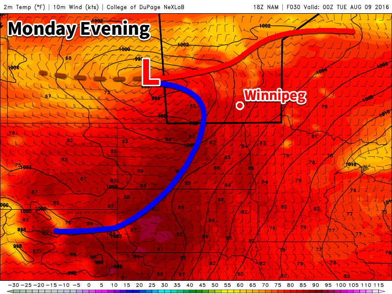
A low pressure system moving into southern Manitoba will bring a risk of severe storms to the region
This Week
Today will be a warm and increasingly humid day across southern Manitoba. High temperatures will generally be in the upper twenties, although some locations may reach the 30C mark. The increased humidity will push humidex values into the mid-upper thirties. The approach of a strong low pressure system will result in a stiff southerly wind developing across southern Manitoba. Wind speeds in the Red River Valley will be 40 km/h gusting to 60 km/h by late afternoon. Other portions of southern Manitoba will also be windy, but with speeds perhaps a bit lower than those in the RRV. This same low pressure system will bring a risk of severe storms to most of southern Manitoba as a cold front slices into this warm, humid air mass. All hazards will be possible with storms that develop, with the primary risks being large hail and damaging wind gusts. Tornadoes will be possible with any storms that remain isolated, although the tornadic risk is somewhat lower than last Wednesday.
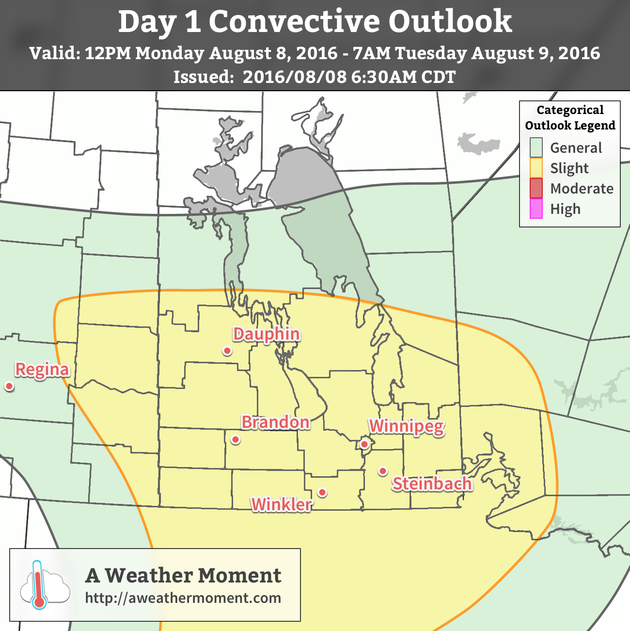
AWM Day 1 Convective Outlook for August 8, 2016
Models hint at an organized convective system perhaps developing out of the afternoon/evening storms. Should such a scenario play out, the Red River Valley and southeastern Manitoba may be at risk for more widespread damaging winds from the evening into the overnight period.
Moisture: Surface dewpoints of 17-21 C are expected across southern Manitoba, with 850 mb dewpoints of 12-15 C by early evening. Moisture is expected to be well mixed within the boundary layer, giving a 100-mb mean mixing ratio of approximately 12-13 g/kg.
Instability: The aforementioned well-mixed boundary layer will sit beneath mid-level lapse rates of approximately 7 C/km. Steep low-level lapse rates will be present owing to the well-mixed, and relatively deep boundary layer. Resulting MLCAPE values will be near 2000-2500 J/kg across south-central Manitoba by early evening. Early evening instability will generally be poor in the Red River Valley and points east, with MLCAPE of 1000 J/kg or less. However, by the late evening period (03Z onward), MLCAPE/MUCAPE will increase to near 2000 J/kg in the region.
Wind Shear: A 50 kt 500-mb jet streak pushing into SW Manitoba will be preceded by approximately 40 kt of westerly flow over southern Manitoba. Except near the surface warm front, surface winds will generally be southerly, and as a result will not enhance the effective bulk wind difference (EBWD) in a notable way. The result will be EBWD values of 30-40 kt across southern Manitoba, with locally higher values near the surface warm front. More interestingly, a strong southerly low-level jet of 30-40 kt is expected over south-central Manitoba by late afternoon. This will result in 0-1 km wind shear of 15-25 kt. Effective storm relative helicity values will also be strong, at 250-400 m2/s2 during the evening. Low-level shear and helicity are also expected to benefit from the decoupling of the boundary layer by mid-late evening, as the LLJ increases to 45 kt by 0300 UTC.
Trigger: The primary trigger for deep convection Monday evening will be a cold front moving in from eastern Saskatchewan and a warm front extending eastward from a low pressure system near the MB/SK border. Forcing for ascent will be quite strong, especially over western Manitoba, where a potent shortwave trough will help knock down heights by the afternoon. The combination of the low-level mesoscale ascent with the surface fronts and mid-level ascent from the incoming shortwave should easily be able to trigger storms by late afternoon across western Manitoba.
Discussion: Severe thunderstorms are likely to develop across western Manitoba/central Interlake beginning Monday afternoon. Initial storms will likely be a mix of supercells and multicell clusters, owing to the strong forcing. Any initial cells that are able to maintain relatively unpolluted surface-based inflow will present a tornado risk, owing to the strong low-level shear/helicity and steep low-level lapse rates. All initial severe cells will be capable of large hail and damaging wind gusts. As the evening progresses, some models hint at upscale growth/cold pool mergers leading to the development of a bowing system over the southern interlake, or adjacent regions. Should such a system develop and have a significant line-trailing cold pool, it would tend to move ESE/SE, potentially impacting Winnipeg, the Red River Valley, and southeastern Manitoba. A system will a less pronounced cold pool may take a most easterly track, primarily avoiding the Red River Valley. Latest models suggest a well-organized, cold-pool driven MCS is the less likely outcome. The overall risk is slight for all of southern Manitoba. A future moderate risk is possible should a forward-propagating system become more likely.
The cold front which triggered today’s storms will pass through the Red River Valley early Tuesday, likely bringing with it some showers and/or weak thunderstorms. After the front clears the region, skies will begin to clear, allowing temperatures to climb into the low twenties by afternoon. Winds will be northerly at 20-30 km/h behind the front.
Wednesday’s forecast remains fairly uncertain at this point. Models hint at the potential for rain across much of southern Manitoba, though the amount and duration of this rain is quite uncertain. Some models bring significant rain to the region, while others bring only light showers. It appears regions along the international border may be at the highest risk for significant accumulations, though that could change as new data becomes available. Outside the rain, skies will be mainly cloudy with temperatures near 20C. Winds will be easterly at 20-30 km/h.
Long Range
The long range forecast shows little change in our pattern over the next couple weeks. Expect to see 1 or 2 weather systems rolling through our region every week, with stormy conditions associated with the passage of each system. Between systems we can expect generally pleasant conditions, with temperatures near to above-seasonal values.