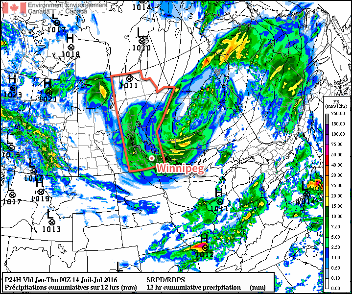
Southern Manitoba will be under the influence of a major low pressure system for one more day, bringing gusty winds and more rain shower activity, before drier conditions begin moving in through the remainder of the week.
Winnipeg & the Red River Valley will continue to be under the influence of a major low pressure system currently located over eastern Manitoba for one more day. Today will see cloudy skies and on and off showers through the day across the region, although they will likely be more numerous through the morning hours. Winds will be quite breezy out of the west to northwest at 30-40 km/h with gusts up to around the 60 km/h mark, and it may even feel more like late-summer thanks to a below-seasonal high temperature of just 18°C.
The rain shower activity will taper off through the late afternoon into the evening hours, leaving mainly cloudy skies in Winnipeg as temperatures head to an overnight low near 13°C. The winds will continue breezy at around 30 km/h.
Around 5mm of rain can be expected from showers across much of Southern Manitoba today.
Thursday will bring mainly cloudy skies, although a bit of sun may be possible late in the day. Winds will be lighter than Wednesday at around 30 km/h out of the northwest. Daytime highs will be a bit warmer throughout the Red River Valley at around 20 or 21°C. A lingering trough may result in a few afternoon showers near the U.S. border and extending back into southwestern Manitoba.
Skies will continue to clear Thursday night as temperatures dip to around 12°C.
Friday will be a pleasant day with light winds, plenty of sun and a high near 23°C.
Winnipeg’s seasonal daytime high is currently 26°C while the seasonal overnight low is 13°C.
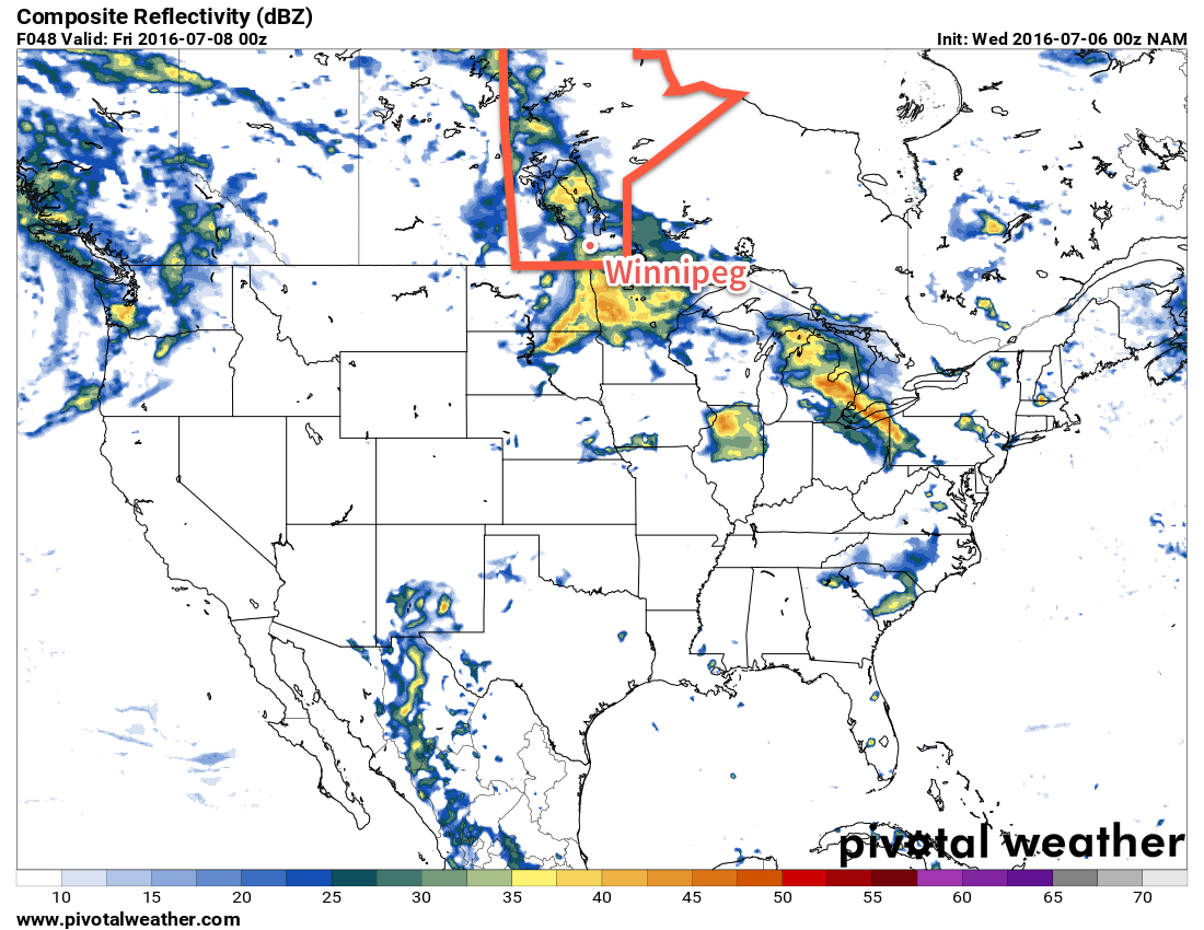
A severe thunderstorm threat returns to Southern Manitoba today as very warm and humid conditions persist in the region for one final day before a cold front pushes cooler and drier air into the region. The passage of the cold front will not be an end to the unsettled weather, though, as a couple more days of showers or thunderstorms will occur with a large upper-level low passing over the region.
Today brings a notable severe weather threat to southern Manitoba with a slight risk of severe thunderstorms developing over southwestern Manitoba and a moderate risk in the Red River Valley eastwards through the SE corner of the province.1 The thunderstorms will develop mid-day and push eastwards with the cold front through the remainder of the afternoon. It is most likely that the thunderstorms develop over southwest Manitoba first, and then push towards into the Red River Valley this evening. Stay aware of any watches or warnings issued by Environment Canada.
The HRRR develops a line of thunderstorms along the cold front and pushes it into the Red River Valley this evening.
Otherwise, this mornings cloud cover will break up a bit to produce mixed skies and the relatively small amount of sunshine will push the daytime highs to around 26°C. With very humid air in place, it will be a fairly uncomfortable day, feeling more like the low- to mid-thirties. After the thunderstorms move through this evening, we’ll head to a low near 16°C with breezy southerly winds.
Tomorrow will likely bring some sun first thing in the morning, but more clouds will move in with a good chance of more shower or thunderstorm activity in the afternoon. At this point severe thunderstorms aren’t expected, but we’ll keep an eye on things to see if anything changes. Winds will be pick up to be gusty out of the north near 40km/h. Expect a high near 23°C and a low near 14°C with a continued chance for showers overnight.
Wednesday will be a cool and cloudy day with a good chance of more rain. The daytime high will only be around 20°C and winds will continue gusty out of the northwest, although not quite as strong as Tuesday. The shower activity will taper off in the evening as temperatures head to a low near 14°C.
The latter half of the week is looking like a return to seasonal temperatures and a chance of actually drying out a little bit.
Winnipeg’s seasonal daytime high is currently 26°C while the seasonal overnight low is 13°C.
Apologies for the lack of an outlook image; time constraints have prevented me from making one. ↩
Unsettled weather is on its way back to the province as a trough of low pressure develops over the western Prairies and draws humid air northwards out of the United States. For people heading out to Bird's Hill for the Folk Fest, this means increasingly muggy weather through the weekend with the potential for thunderstorms both Saturday & Sunday.
Today will be a fairly pleasant day. The system that brought up to 20 mm of rain to the Red River Valley yesterday1 will be moving off the east and any remaining cloud from it should clear out through the morning leaving just a few clouds around for the afternoon. Temperatures will climb to a high near 25°C. Expect just a few clouds overnight and a low near 14°C.
Saturday
Saturday will see more humid air beginning to work into the region. Morning sun will be replaced by clouds as the day goes on while the temperature climbs to a high near 26°C. There will be a slight chance of thunderstorms in the evening, but the main threat will occur through the overnight period. There will be a very small chance of severe thunderstorms.
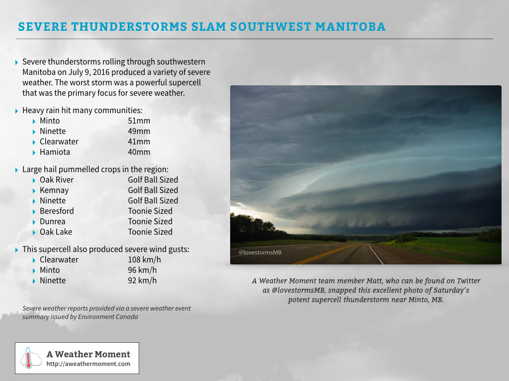
Update: Severe Thunderstorms Hit SW Manitoba on Saturday July 9, 2016
Severe thunderstorms developed over SW Manitoba on Saturday and focused into one primary strong supercell thunderstorm that organized near Virden, MB and then moved southeastwards through Minto & Ninette before continuing on across the US border. It produced a variety of severe weather, with numerous reports of heavy rain, large hail and severe winds:
A summary of the severe weather over southwestern Saskatchewan on July 9, 2016
Sunday
Sunday will see the humidity move into the region full force with dewpoint values climbing up into the low 20's. This will make the high near 27°C feel very warm, however conditions will be a bit more bearable due to the fair amount of cloud cover expected through the day. Any times the sun does poke out, though, will likely see things begin feeling very warm very quickly.
A organized line of thunderstorms sweeping across Southern Manitoba is possible Sunday night.
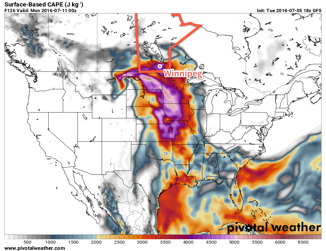
Rain-wise, we may see some remnant showers or thunderstorms in the morning from any activity on Saturday night, and then things should diminish for much of the day. By Sunday evening & overnight, the thunderstorm threat once again returns. Sunday night will see a slight to moderate threat of severe thunderstorms across the Red River Valley. Large MUCAPE values overnight coupled with 30-50 kt of bulk shear ahead of an incoming shortwave will support the development of organized thunderstorm activity across a wide area of Southern Manitoba. The primary threats will be large hail and strong winds, with rapid rainfall accumulations also a concern.2
It will be a very mild night with a low near 21°C.
Long Range
The start of next week continues warm and humid with a thunderstorm threat late in the day into the overnight period. Heading through Tuesday into mid-week, the main upper low associated with the weekend's weather pattern moves into the region, bringing relief from the humidity and cooler temperatures alongside more cloud and chances for showers.
While Winnipeg saw nothing but a few light showers late in the evening, the rain managed to push as far north as St. Adolphe, which saw 2mm. ↩
Although the thunderstorms will likely have very intense rainfall, they will be moving relatively quickly, making accumulations not as prominent a threat as the hail or wind potential. ↩
Anyone looking for a good long stretch of hot, dry weather really should consider broadening their horizons because generally unsettled weather continues throughout Southern Manitoba right through the coming weekend.
Today will be the most pleasant and "summer-like" day of the coming few as the sun makes a prominent showing with temperatures climbing into the mid-20's for a daytime high. While some showers or thunderstorms are possible over southwestern Manitoba today, Winnipeg & the Red River Valley should see just a few clouds with no precipitation expected.
Tonight will continue to be fairly pleasant with a low near 13°C.
Thursday will bring unsettled weather back to Winnipeg as an upper low moves into southern Manitoba. Increasing cloudiness and showers will spread from the southwestern Red River Valley to the northeast through the morning, and then the unsettled conditions will persist through the afternoon. At this point no thunderstorm activity is expected. Temperatures will reach a high near 23°C and then head to a low near 14°C on Thursday night with a continuing chance of showers.
Several models are showing an area of rain or showers moving through the Red River Valley on Thursday afternoon.
Friday will continue with fairly cloudy skies and a slight chance of more light shower activity. Some sunny breaks are possible in the afternoon as the temperature climbs to a high near 23 or 24°C. Temperatures will drop to around 14°C with clearing skies.
Hot, Unsettled & Increasingly Humid This Weekend
The weekend weather will be dominated by a developing trough of low pressure through the western and central Prairies that will draw humid air northwards from the Central Plains of the United States and bring with it the potential for multiple days of thunderstorm potential. Early indications are that severe thunderstorms will certainly be possible on both Saturday and Sunday. Highs will be in the upper 20's with Sunday in particular beginning to feel very muggy.
The GFS is forecsting potent SBCAPE values in excess of 4,000 J/kg by Sunday evening.
With the Winnipeg Folk Festival starting off this weekend, we'll be sure to keep a close eye on this system as it develops. Early indications are that the days will be fairly pleasant with more of a chance for thunderstorms through the overnight periods both Saturday night and Sunday night. By Sunday, there may be a significant severe threat with any thunderstorms due to the sheer amount of instability that is forecast to be in place over the region. We'll have a closer look at the weekend forecast on Friday morning.
Winnipeg’s seasonal daytime high is currently 26°C while the seasonal overnight low is 13°C.