Cooling Down for Awhile

Conditions will cool down this week, but temperatures won’t stray that far from normal.


A cold front will pass through southern Manitoba on Monday

Monday

Monday
10°C / 2°C
Mix of sun and cloud

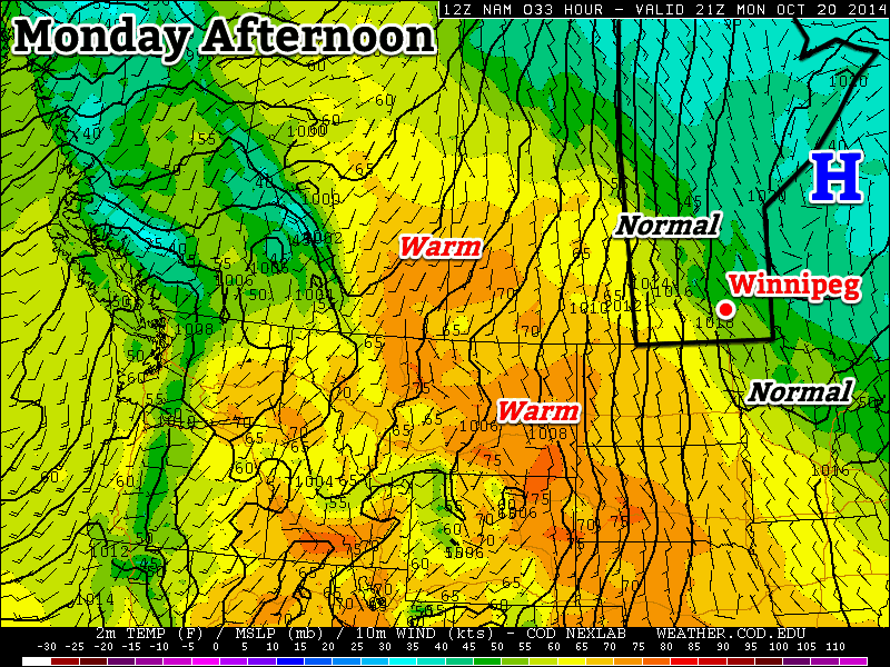
Today will be a transition day as a cold front moves through southern Manitoba. The front won’t pass through in dramatic fashion, so you probably won’t even notice it. However, it will set up cooler weather for the next few days. Despite the passage of that front, temperatures today will remain above seasonal, with highs near 10C and light winds.

Tuesday

Tuesday
4°C / 0°C
Mainly cloudy with chance of showers or flurries

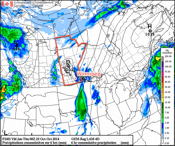
Tuesday will be a much cooler day in the wake of Monday’s cold front. High temperatures will be in the single digits with a breezy north-west wind. There may be some light showers or even gasp flurries during the day, but accumulations should be minimal.

Wednesday

Wednesday
5°C / -2°C
Mainly cloudy

Wednesday will remain on the cool side with temperatures remaining in the single digits. No precipitation is expected, but skies will likely be mainly cloudy. The wind will be light and from the south or south-east.

Long Range

The long range forecast continues to look good. The NAEFS suggests that above-normal weather will persist into November. So far there is no sign of any significant snowfall in the forecast, which is always a good thing!

Temperatures To Remain Above-Normal Despite Cool Down

A cold front passing through Southern Manitoba later today will usher in cooler air, but temperatures will only dip slightly and remain above-normal through the weekend.

Friday
16°C / 5°C
Mixed skies; windy in the afternoon

Saturday
11°C / 2°C
Mainly sunny

Sunday
12°C / 5°C
Mainly cloudy wiht a chance of showers

Friday Brings Blustery Winds

Today will be a warm day across the Red River Valley with daytime highs in the 15–16°C range – around 8°C above the normal daytime high of 7°C – under mixed skies trending towards cloudier this afternoon. A tightening pressure gradient coupled with an advancing cold front will bring fairly gusty winds into the province this afternoon, with southerly winds shifting to westerly-to-northwesterly and increasing in speed to 35–45km/h with gusts as high as 60–70km/h. No precipitation is expected with the passage of the cold front.

The 850mb temperatures from the NAM model clearly show the cold front passing through Southern Manitoba this afternoon.

Temperatures will drop to around 5°C tonight under clearing skies.

Mixed Weekend Ahead

Saturday is shaping up to be a very nice day with a few clouds, diminishing winds and a high near 11°C. Saturday night should bring clear skies and a low near 2°C.

Sunday will see a warm front lift into the Red River Valley, resulting in a mainly cloudy day with a chance of showers as the front moves through; it’s looking like the rain potential is in the afternoon at this point. Expect a high in the low teens alongside some breezy southeasterly or easterly winds moving towards an overnight low around 5°C.

Warm Weather Continues

Above-normal temperatures[1] will continue through the remainder of the week as a southwesterly flow aloft continues to pump relatively mild Pacific air over the Prairies.

Wednesday
17°C / 8°C
Increasing cloud with a chance of showers

Thursday
15°C / 7°C
Mainly cloudy

Friday
16°C / 5°C
Some morning cloud, then sunny

Unsettled Wednesday

Today will be the most unsettled day of the week thanks to a (very) weak cold front pushing eastwards across the Red River Valley today. A fairly sunny start to the day will become more mixed by mid-day with a slight chance of shower activity in Winnipeg mid-day into the early afternoon. It seems most likely that the activity will remain to the east of Winnipeg, with showers or even thunderstorms almost a certainty in the Whiteshell southwards to the US border.

Precipitation forecast for this afternoon from the Canadian RDPS model.

The American NAM weather model has been an outlier for several runs in a row, producing a fairly potent band of showers and thunderstorms over the western Red River Valley and pushing eastwards through the day. Given the weak surface forcing, mediocre moisture and the rate and evolution of the upper-level destabilization, it seems that the NAM is probably over-doing things and not a likely forecast. It’s worth mentioning here as an outside possibility, though, given its consistency in producing that outcome.

Other than the showers, strong southerly winds at 40 gusting 60km/h will taper off this afternoon behind the weak cold front as they shift to westerly at around 20km/h. The temperature will climb to around 17°C today.

Skies will clear out this evening as the temperature drops near 8°C for the overnight low.

Pleasant End to the Week

Thursday and Friday will both be pleasant fall days – especially for late October. Dry weather will be the name of the game for both days with highs in the mid-teens and fairly light winds. Some cloud will push across the Red River Valley on Thursday night but otherwise things will be mainly sunny/clear. The temperature will dip to around 6 or 7°C on Thursday night and a bit cooler – near 5°C – on Friday night.

Heading into the weekend, the weather continues to look pleasant with highs in the teens, no real threat of rain and plenty of sunshine. Enjoy!


  1. Normal daytime highs for this time of year sit around the 8°C mark.  ↩

Above-Normal Temperatures to Start the Week

More above-normal weather is in store to start the week – what’s not to like!

Temperatures on Monday will be near normal in Southern Manitoba

Monday

Monday
11°C / 3°C
Mainly Sunny

Today will see near normal temperatures in southern Manitoba. Highs will be around or just above 10C with mainly sunny skies. Winds will be light, making for pleasant conditions overall.

Tuesday

Tuesday
17°C / 8°C
Mainly Sunny

Tuesday will see above-normal conditions return to southern Manitoba. Temperatures will be in the mid to upper teens with skies remaining mainly sunny. A strong south-east wind will be in place throughout the day, putting a bit of an edge on what would otherwise be a very nice day.

Wednesday

Wednesday
16°C / 8°C
Mainly cloudy with chance of showers

Warm weather will continue on Wednesday, with temperatures remaining in the mid teens. A weak low pressure system is expected to pass through southern Manitoba during the day, possibly producing some showers in its vicinity. This system will also likely bring in some heavier cloud cover, so Wednesday probably won’t be as sunny as Monday and Tuesday.

Long Range

Long range modelling suggests that above-normal weather [1] will continue through the end of October. That doesn’t mean that every single day will be warmer than normal, but the majority should be. Enjoy the pleasant end to October!


  1. Normal highs for the last stretch of October sit around 9°C.  ↩