A Fairly Pleasant Weekend

Although temperatures will be a little below normal for foreseeable future, a fairly pleasant few days are on tap for Winnipeg. A ridge of high pressure over the central Prairies will work at clearing out the clouds giving us plenty of sun for Friday and Saturday while winds slowly diminish. A low passing through on Sunday will mark the return of potentially rainy weather.

Friday
19°C / 7°C
Sunny with afternoon clouds. Breezy.

Saturday
18°C / 7°C
Mainly sunny.

Sunday
18°C / 8°C
Cloudy periods with a chance of showers.

Significantly cooler air than seen over the past week is working its way across the Prairies into Southern Manitoba, dropping daytime highs from the the mid-to-high 20s to the high teens. Temperatures will remain roughly 5°C below normal for the next week as a much cooler pattern locks in; daytime highs aren’t expected to reach over 20°C until late into next week.

Today will bring some late morning/afternoon cloud with a breezy west-to-northwesterly wind at around 20-30km/h. Temperatures will reach around 18°C. Expect clearing skies tonight and a low of around 7°C.

Tomorrow will be very similar to today except with a little less cloud and lighter winds. High near 18°C once again and a low near 7°C again.

Showery Sunday?

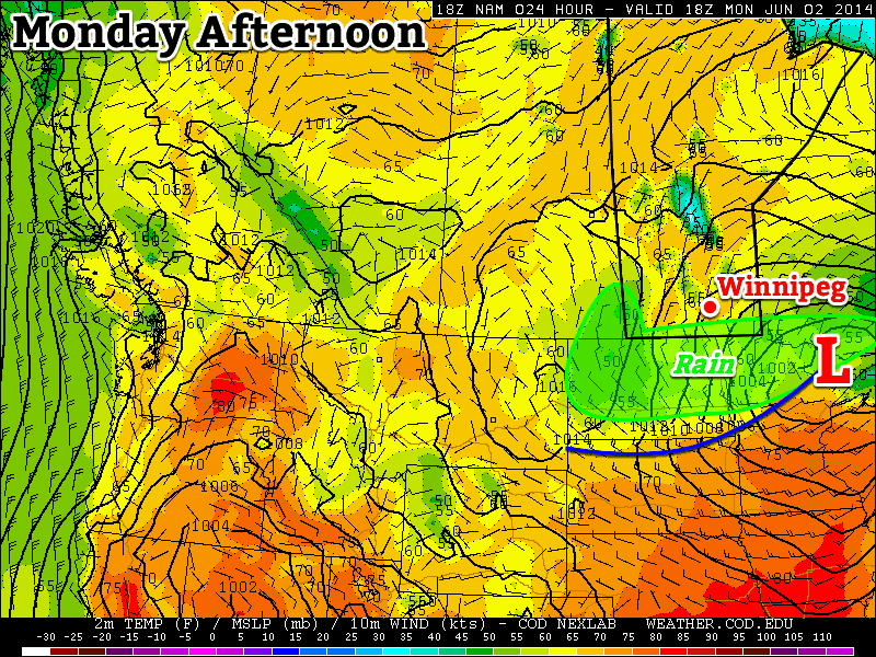
A weak low pressure system is forecast across Southern Manitoba on Sunday, bringing a renewed chance of showery weather. At this point, it looks like little in the way of particularly active weather will occur; even a rumble of thunder looks out of the question.

Probability matched mean precipitation from the SREF model for Sunday morning.

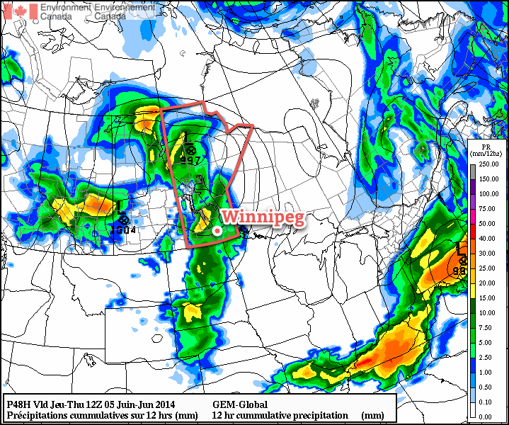
In general, the system is expected to spread some light shower activity from west to east across Southern Manitoba through the morning hours, persisting into the afternoon. Overall amounts look to be low; in the image above, I’ve used a probability matched mean ensemble[1] which can better capture higher amounts embedded within the mean precipitation field, and it still only shows around 2-4mm for most areas.

There are some hints the system may pick up strength and produce 5-10mm over the woods from Pinawa down to Sprague, but it’s still a little too far out to say much reliably.

Sunday won’t be all showers and cloud, though with a good chance of a few sunny breaks through the day. Highs will be near 18°C once again with an overnight low around 8°C.

Heading into next week it looks as if the cooler temperatures will continue with a couple more chances for precipitation through the first half of the week.


  1. For those who are curious, this takes the ensemble mean value, but matches the rain rate distribution in the ensemble mean field to the complete ensemble. Can help prevent “smearing” of the precipitation field.  ↩

Sunshine Gives Way to Unsettled Weather

The beautiful summer weather will stick around for one more day before a large upper trough pushing across the Prairies spreads showers and generally unsettled weather into Southern Manitoba.

Forecast precipitation for Wednesday night from the RDPS.

Today will be an almost ideal summer day across much of the Red River Valley. Sunny skies will gradually see increasing cloudiness through the afternoon hours, however before things cloud up temperatures will climb all the way up to around 27 or 28°C while light winds begin picking up in the afternoon to 20-30km/h.

Wednesday
27°C / 14°C
Increasing cloudiness in the afternoon.

The story will be a little different over southwest Manitoba today, where an incoming surface trough will combine with warm weather and moderate instability to produce mid-to-late afternoon thunderstorms. Around 1250J/kg of CAPE will combine with 25kt of bulk shear and a 25-30kt LLJ to support upscale growth from a few isolated thunderstorms to an eastward moving line by the evening. This line will weaken fairly quickly as it moves into the Red River Valley thanks to the loss of daytime heating and the storms moving away from their main support.

The overall threat of severe weather in southwest Manitoba is marginal. The main risks will be large hail, but that seems like a fairly off chance at best. A rogue wind gust can’t be ruled out either, but again, I don’t have particularly high expectations for severe weather. Were I the SPC, it would be a “See Text” sort of day.

This line will bring a chance of showers or thunderstorms to Winnipeg and the Red River Vally through the overnight hours. No severe weather is expected. Temperatures will drop down to around 15°C or so.

Thursday & Friday

Thursday
25°C / 10°C
Cloudy periods; slight chance of showers.
Friday
21°C / 8°C
A mix of sun and cloud.

Tomorrow will bring cloudy periods with a slight chance of showers through the day. The precipitation risk will increase towards evening as a second impulse digs the upper trough into Manitoba, leaving us with a chance of showers on Thursday night.

Cooler air will also start filtering in. Thursday’s high of 25°C will be replaced by cooler weather for the remainder of the week and weekend. The temperature will drop to around 10°C on Thursday night.

Things should push off to the east on Friday morning leaving behind some sunny skies, but skies look to become mixed midday. There may be a chance of seeing some rain on Friday afternoon, but guidance is very mixed right now as to whether or not a band of rain will push northeastwards out of North Dakota. At this point it seems more likely that things will stay dry than not. We’ll see highs across the Red River Valley top out around the 21°C mark. The overnight low on Friday night will drop into the high single digits.

The Weekend

The weekend across the Red River Valley is looking fairly nice, albeit a little cool. Saturday will see afternoon cloudiness bring a slight chance of late-day showers. Sunday looks fairly sunny, although cloud will likely increase in the evening ahead of another system forecast to push through the region on Monday. Highs will sit near the 20°C mark with overnight lows in the mid-to-high single digits.

Normal Weather Through Early Week

The first part of this week will feature fairly typical early-June conditions, with temperatures in the low twenties and a chance of rain.

 Areas along the International Border may see some rain on Monday
Areas along the International Border may see some rain on Monday

Monday

Monday
18°C / 9°C
Chance of Showers

Today will see a chance of showers over all of southern Manitoba. In areas near the International border, there may be more than showers, with periods of rain and perhaps even some embedded thunderstorms. Accumulations along the border should generally not exceed 15mm, but there could be locally higher amounts if any thunderstorms develop. In areas further north, such as Winnipeg, it should be a fairly uneventful day overall, with temperatures in the upper teens and a breezy north wind.

Tuesday and Wednesday

Tuesday
23°C / 10°C
Mainly Sunny
Wednesday
25°C / 13°C
Mainly Sunny

Tuesday and Wednesday look like uneventful days in southern Manitoba. Temperatures will be in the low to mid twenties with light winds and mainly sunny skies. There’s certainly nothing wrong with that!

Long Range

The long range forecast suggests we may see a risk of thunderstorms on Thursday, followed by cooler weather for late week into the weekend. We’ll likely rebound to seasonal or above-seasonal values at some point next week.

Quieter Weather

After what ended up being a fairly busy thunderstorm week considering it’s not even June yet, the weather is expected to settle down for the next while with pleasantly mild temperatures and little in the way of precipitation.

Friday
25°C / 15°C
Cloudy with sunny breaks. Chance of showers or thunderstorms this morning. Chance of showers overnight.

Saturday
24°C / 13°C
Mainly cloudy; clearing later in the day.

Sunday
22°C / 13°C
A few clouds.

Friday

Today will be quite a pleasant day overall. Any remaining showers along the cold front will move through by midday, then leaving us with mostly cloudy skies, although we’ll likely see a few sunny breaks. Temperatures will be mild with a high near 25°C and winds will be fairly light out of the northwest.

Skies will be cloudy tonight as a disturbance tracking through North Dakota spreads some cloud and showers northwards. Here in Winnipeg, there’s only a very marginal chance that we might see some light shower activity. The risk will increase in the Red River Valley towards the US border, with the greatest risk being in the SE Red River Valley. Even so, amounts are only looking to be in the 2-4mm range.

Expected precipitation from the NAM on Saturday night.

For any weekend campers, the Sprague region looks likely to see some rain tonight with accumulations of around 5-10mm. Further north in the Whiteshell there’s only a chance of showers similar to that in the Red River Valley.

The overnight low in Winnipeg will be near 15°C.

The Weekend

The weekend is shaping up to look very nice. Saturday will bring mixed-to-cloudy skies clearing sometime late in the day or in the evening. There may be a slight chance of a few light, lingering showers through the morning.
The high will be around 23 or 24°C and the overnight low will drop to near 13°C.

Sunday will bring mainly sunny skies with some scattered afternoon clouds and a high in the low 20’s. Sunday night will feature clear skies and a low near 13°C.