Seasonal to above seasonal weather will continue this week, a nice change from the miserable first part of May.
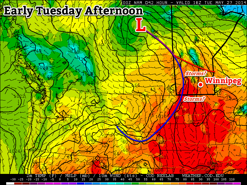
There will likely be a chance of thunderstorms in southern Manitoba on Tuesday
Monday
Monday
24°C / 13°C
Mix of sun and cloud
Today will feature much calmer weather than what was experienced on the weekend. High temperatures will be in the low to mid twenties in southern Manitoba under a mix of sun and cloud. The wind will generally be light and from the north or east.
Tuesday
Tuesday
27°C / 15°C
Mix of sun and cloud with risk of a thunderstorm
The threat for thunderstorms will resume in southern Manitoba on Tuesday. At this point there is still a lot of uncertainty as to how the thunderstorm risk will evolve. At the high end, there could be numerous severe storms, and even a slight tornado risk. At the low end, storms would likely just produce small hail and gusty winds. It’s too early to say what the storm mode will be on Tuesday, but bear in mind that severe storms are a possibility. The chance of thunderstorms on Tuesday will make the temperature forecast a bit uncertain as well. If there are no storms, and therefore no additional cloud cover, then we’re looking at temperatures in the upper twenties. However, if there is additional cloud from thunderstorm activity, then highs will probably be in the mid twenties. More details on Tuesday’s potential for storms will no doubt be found in the comments below over the next couple days.
Wednesday
Wednesday
25°C / 16°C
Mix of sun and cloud with risk of a thunderstorm
Wednesday is another tricky forecast, as rain may or may not affect the forecast again. Some weather models bring an area of rain and thunderstorms through southern Manitoba in the morning, which would greatly impact the temperature forecast. Like Tuesday, it’s too early to say if this will happen, but it’s certainly a possibility. High temperatures in the mid twenties look most probable, but that outlook could change depending on what happens with the chance of rain.
Long Range
The long range forecast continues to look stormy through the end of the week. Most weather models suggest that there will be a risk of severe thunderstorms in southern Manitoba on Thursday and/or Friday. I feel like I’m saying this a lot, but there is still a lot of uncertainty in this part of the forecast. Models are still not correctly resolving the speed of this system, and until that happens it will be tough to say much about the thunderstorm potential with any certainty. Beyond this week, the weather will likely stay near, to slightly above seasonal values, a nice way to transition into June!
Southern Manitoba is set to bathe in summer-time warmth as temperatures soar well above normal.
A broad upper-level trough developing over the Rocky Mountains will combine with a strengthened sub-tropical ridge over the southeastern United States to produce a southerly flow that will bring substantially warmer air to our region. As well as the warmer temperatures, humidity will become more noticeable heading into the weekend as higher dew point temperatures are advected northwards into the region. With the warmer weather will also come the potential for some shower or thunderstorm activity across much of Southern Manitoba.
Friday
25°C / 16°C
Mainly sunny. A little breezy.
Saturday
30°C / 17°C
Cloudy periods with a slight chance of showers or thundershowers. Windy and warm.
Sunday
24°C / 14°C
Chance of a morning shower or thunderstorm.
Friday
Today will be a very pleasant day. Under a mainly sunny sky, the temperature will climb to near 25°C as a southerly wind at 20-30km/h provides just enough of a breeze to keep things comfortable. The humidity will be more prominent than it’s been so far this year, but it will still be quite comfortable with dew point values climbing to around 15°C.
Heading into the night, temperatures will drop to about 16°C with variable cloudiness through the overnight hours with a slight chance of some shower .
Saturday
Tomorrow will start with a fair amount of mid-level instability riding ahead a warm front pushing eastwards. This will present itself with a slight risk for showers or thunderstorms through the early morning. Afterwards, we’ll see cloudy periods with fairly windy conditions with a southerly wind at around 30-40km/h. Very warm air will work in aloft, driving our daytime high up to 29 or 30°C. In addition to the warmer air, the southerly winds will also advect more humid air northward with the dew point climbing towards 17 or 18°C which will start to make it feel a little sticky outside.
Temperatures of 30°C or greater (dark green) are expected across much of Manitoba on Saturday.
As everything heats up, there will be a potential for thunderstorms, but there will be little in the way of a threat for severe storms. If we quickly look at the ingredients required for thunderstorms:
Moisture: Dew points will climb into the mid-to-upper teens, through a suitably deep layer, and be supportive of storm generation. The dew points are on the low side for the atmospheric thermal profile which will result in relatively high-based storms.
Instability: Deep instability will be present. Mid-levels are fairly unstable, and low-levels will destabilize fairly dramatically by mid-afternoon thanks to intense surface heating driving temperatures towards 30°C.
Shear: This is where things fall apart. While the low-level winds will provide favourable inflow into the storm bases, winds will be very slack through the mid-levels. This will dramatically impact the ability for storms to organize and will limit their potential growth.
Trigger: Triggers for storm generation look fairly weak. The synoptic triggers look to remain outside our region; the warm front will be in Central Manitoba, the cold front will be hanging back through Central Saskatchewan and the main warm sector trough also will trail back into southeastern Saskatchewan. The intense surface heating will likely produce many mesoscale triggers, especially along significant terrain such as the western escarpment of the Red River Valley and the Riding Mountains.
As a result, we’ll see the potential through much of Southern Manitoba for thunderstorms, however they’ll likely be short-lived, high based storms whose main threat will be strong winds or large hail.
It’s likely that rain with embedded thunderstorms will develop in North Dakota on Saturday night and lift northeastwards into Southern Manitoba, bringing the risk of rain and thunderstorms to somewhere in Southern Manitoba through the overnight period into Sunday morning. The areas that will see the risk will depend highly on exactly where the precipitation develops in North Dakota.
Temperatures will remain quite mild Saturday night with the overnight low bottoming out at only around 17°C.
Sunday
Sunday will be the most organized day for precipitation of the weekend. The system bringing the warmer air to the province will push off to the East through the day, dragging a cold front across the province. Widespread showers and thundershowers will be associated with the cold front as it pushes eastwards, and as a result showery weather is likely. It’s a little early for too much detail, but it seems like the chance for precipitation will start around mid-to-late morning and taper off by late afternoon.
The temperature will climb to around 23 or 24°C before the cold front swings through. Things will clear up by Sunday evening and we’ll see a beautiful night with a low near 14°C.
Next week looks to continue the warmth with highs in the mid-20’s, but by mid-week it looks like unsettled weather will return to Southern Manitoba and bring multiple days with chances for showers or thunderstorms. It seems like we’ll lock into seasonal to above seasonal temperatures, so get out and enjoy the summer weather that we’ve all waited so long to see!
After another stretch of below-normal temperatures, some truly summer-like weather is finally on the way.
Winnipeg will be under the influence of a ridge of high pressure that will keep us dry through the remainder of the week. A developing flow from the Gulf of Mexico looks poised to set up Southern Mantioba for a quick shift into summer-like weather for the end of the week.
Wednesday
15°C / 6°C
Mixed skies with a clearing trend.
Thursday
23°C / 12°C
Mainly sunny.
Friday
26°C / 14°C
Mainly sunny.
Today will bring mixed skies to Winnipeg and the Red River Valley as the system cloud associated with the low that moved through on Monday and Tuesday begins exiting the province. Cloud will likely persist through the afternoon as some fair weather cumulus develop as we warm up to our high near 15°C. Skies will clear tonight as the temperature drops. The temperature will drop to around 6°C tonight.
Tomorrow will bring mainly sunny skies, relatively light winds and a high temperature returning to a seasonal to slightly above seasonal 22 or 23°C. Things will be calm and mainly clear Thursday night with temperatures dropping to near 12°C.
Friday will mark the shift towards decidedly more summer-like weather. Under mainly sunny skies, warmer air pushing into the region will push our daytime high towards around 26°C. In addition to the warmer weather, we should also see the first days of the year that could potentially be considered “humid.” For a quick summary of the relationship between dew point and how humid it feels, and why relative humidity is a poor choice, check out the brief primer at the bottom of this post.
There’s uncertainty in exactly how humid it will get here in Southern Manitoba. Some weather models, such as the Canadian GDPS[1] are pushing dew point values as high as 20°C in the Red River Valley, but values that high are likely overdone thanks to the delayed start to the growing season due to the abnormally cold spring. It’s likely we see dew points climb into the mid-teens at least, though, so it’s fairly safe to expect that we’ll be seeing our first real shot of summer heading into the weekend.
Unsettled Weekend
There’s still a lot of uncertainty associated with the large amplitude upper-level pattern that’s expected to develop this weekend, so in general vagueries…
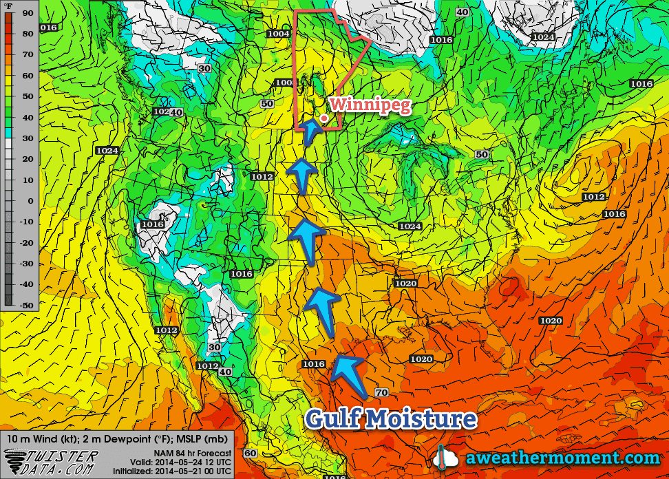
As the NAM shows, a broad flow from the Gulf of Mexico all the way to Southern Manitoba will be established by Saturday morning.
It’s going to be quite warm on Saturday. Daytime highs in the upper 20’s seem quite likely as well as dew points climbing into the mid-to-upper teens, although as mentioned above, there’s some uncertainty to exactly how high the dew points will get. Sunday will also be warm with highs in the mid-20’s.
Thunderstorms, potentially severe, will be possible both days, although exactly when and where is far too uncertain at the moment. It seems entirely possible that the thunderstorm activity will be constrained to the evening/overnight periods when elevated thunderstorms can develop, although late afternoon severe storms cannot be ruled out at this point. For both days the best chance for thunderstorms appears to be over Parkland Manitoba, SW Manitoba and into SE Saskatchewan and Montana/North Dakota. Here in the Red River Valley, nocturnal elevated activity looks like the most plausible scenario.
We’ll be taking a closer look at the thunderstorm and severe weather potential in Friday’s post. Until then, enjoy the imminent summer weather!
A Quick Lesson on Dew Points
Perhaps the most convenient way to quantify how humid it is outside is to look at the dew point temperature. The dew point is the temperature where water evaporates into the air at the same rate that it condenses out of the air; to put that in simpler terms, if the air comes in contact with something cooler than the dew point, water will condense out of it. Think of it as the temperature your cold glass of your favorite hot weather beverage needs to be to “sweat”.
The higher the dew point temperature is, the more water is in the air. This is an important distinction from relative humidity. Air has a quirky trait that allows it to hold more water the warmer it is. This means that air at -5°C cannot hold as much water as air at 25°C. This makes relative humidity ambiguous since it is a measure of how much water is in the air versus how much water the air can hold, or “how full the glass is.”
So a relative humdity of 100% at -5°C has less water in the air than a day where the temperature is 10°C with a relative humidity of 35% because the dew point in the first case is -5°C, while in the second case, despite the relative humidity of only 35%, the dew point is around -4.8°C.
As the dew point climbs, your perception of it being humid increases as well. In general, once the dew point rises to around 15 or 16°C, you’ll begin to notice that it feels humid. By 18 or 19°C it can begin to be uncomfortable. By the time the dew point climbs into the low-to-mid 20’s, as long as there’s sunshine, it can be extremely sticky feeling outside. Dew points in excess of 25°C are dangerous and can pose extreme health risks.
The final day of the Victoria Day long weekend will see rain over much of southern Manitoba. It seems that early-week rain is becoming a new tradition of sorts.
A low pressure system will bring rain to much of southern Manitoba on Victoria Day
Monday
Monday
16°C / 9°C
Periods of rain.
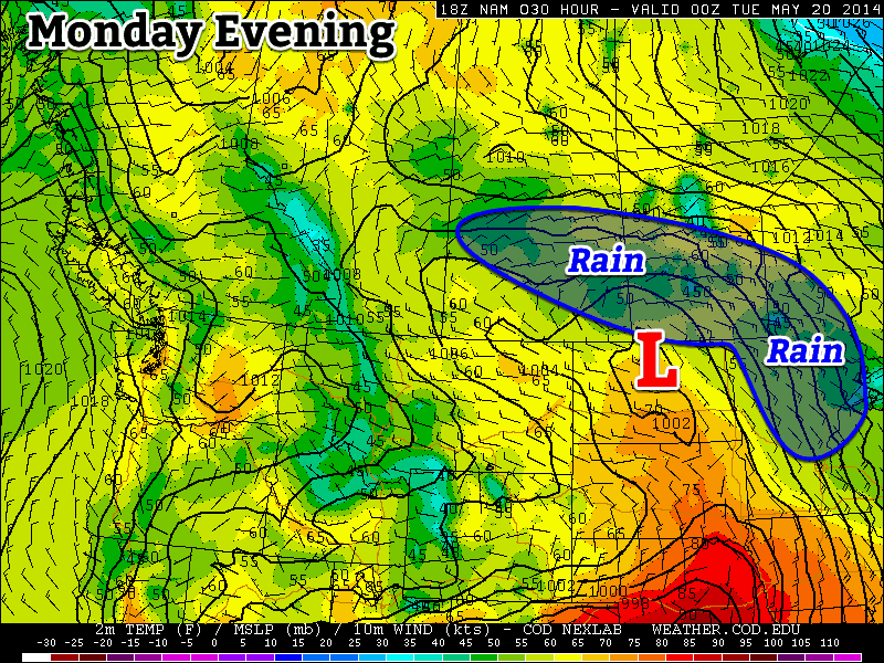
A low pressure system moving out of the northern United States will bring moderate rain to most of southern Manitoba today. Accumulations of 5-15mm are expected in Winnipeg and the Red River Valley. Areas further west, in south-western Manitoba, can expected accumulations of 15-25mm. There’s a slight chance of a thunderstorm in areas near the international border, but they should amount to little more than a rumble or two and slightly heavier rainfall.
Tuesday
Tuesday
13°C / 10°C
Showers.
The low pressure system from Monday will remained stalled out over southern Manitoba on Tuesday. That means we’ll see showers continue through the day on Tuesday, but actual rainfall accumulations will generally be light.
Total rainfall expected from Sunday evening to the time everything tapers off on Tuesday evening.
Wednesday
Wednesday
16°C / 4°C
Mainly sunny.
The weather will finally begin to relent on Wednesday, as skies clear and temperatures climb into the mid or upper teens. There will be a breezy north wind on Wednesday, but it will be a nice day overall. Wednesday’s return to reasonable weather signals a major pattern change that is expected to bring much warmer conditions by the weekend.
Long Range
The long range forecast is finally looking hot for a change. Medium-range weather models suggest we could reach the upper twenties, or near thirty degrees by the weekend. There’s still some uncertainty in terms of how hot it will get, but it definitely looks like some above normal weather is finally on the way!