After another stretch of below-normal temperatures, some truly summer-like weather is finally on the way.
Winnipeg will be under the influence of a ridge of high pressure that will keep us dry through the remainder of the week. A developing flow from the Gulf of Mexico looks poised to set up Southern Mantioba for a quick shift into summer-like weather for the end of the week.
Today will bring mixed skies to Winnipeg and the Red River Valley as the system cloud associated with the low that moved through on Monday and Tuesday begins exiting the province. Cloud will likely persist through the afternoon as some fair weather cumulus develop as we warm up to our high near 15°C. Skies will clear tonight as the temperature drops. The temperature will drop to around 6°C tonight.
Tomorrow will bring mainly sunny skies, relatively light winds and a high temperature returning to a seasonal to slightly above seasonal 22 or 23°C. Things will be calm and mainly clear Thursday night with temperatures dropping to near 12°C.
Friday will mark the shift towards decidedly more summer-like weather. Under mainly sunny skies, warmer air pushing into the region will push our daytime high towards around 26°C. In addition to the warmer weather, we should also see the first days of the year that could potentially be considered “humid.” For a quick summary of the relationship between dew point and how humid it feels, and why relative humidity is a poor choice, check out the brief primer at the bottom of this post.
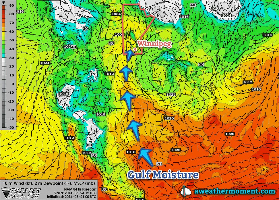
There’s uncertainty in exactly how humid it will get here in Southern Manitoba. Some weather models, such as the Canadian GDPS[1] are pushing dew point values as high as 20°C in the Red River Valley, but values that high are likely overdone thanks to the delayed start to the growing season due to the abnormally cold spring. It’s likely we see dew points climb into the mid-teens at least, though, so it’s fairly safe to expect that we’ll be seeing our first real shot of summer heading into the weekend.
Unsettled Weekend
There’s still a lot of uncertainty associated with the large amplitude upper-level pattern that’s expected to develop this weekend, so in general vagueries…
It’s going to be quite warm on Saturday. Daytime highs in the upper 20’s seem quite likely as well as dew points climbing into the mid-to-upper teens, although as mentioned above, there’s some uncertainty to exactly how high the dew points will get. Sunday will also be warm with highs in the mid-20’s.
Thunderstorms, potentially severe, will be possible both days, although exactly when and where is far too uncertain at the moment. It seems entirely possible that the thunderstorm activity will be constrained to the evening/overnight periods when elevated thunderstorms can develop, although late afternoon severe storms cannot be ruled out at this point. For both days the best chance for thunderstorms appears to be over Parkland Manitoba, SW Manitoba and into SE Saskatchewan and Montana/North Dakota. Here in the Red River Valley, nocturnal elevated activity looks like the most plausible scenario.
We’ll be taking a closer look at the thunderstorm and severe weather potential in Friday’s post. Until then, enjoy the imminent summer weather!
A Quick Lesson on Dew Points
Perhaps the most convenient way to quantify how humid it is outside is to look at the dew point temperature. The dew point is the temperature where water evaporates into the air at the same rate that it condenses out of the air; to put that in simpler terms, if the air comes in contact with something cooler than the dew point, water will condense out of it. Think of it as the temperature your cold glass of your favorite hot weather beverage needs to be to “sweat”.
The higher the dew point temperature is, the more water is in the air. This is an important distinction from relative humidity. Air has a quirky trait that allows it to hold more water the warmer it is. This means that air at -5°C cannot hold as much water as air at 25°C. This makes relative humidity ambiguous since it is a measure of how much water is in the air versus how much water the air can hold, or “how full the glass is.”
So a relative humdity of 100% at -5°C has less water in the air than a day where the temperature is 10°C with a relative humidity of 35% because the dew point in the first case is -5°C, while in the second case, despite the relative humidity of only 35%, the dew point is around -4.8°C.
As the dew point climbs, your perception of it being humid increases as well. In general, once the dew point rises to around 15 or 16°C, you’ll begin to notice that it feels humid. By 18 or 19°C it can begin to be uncomfortable. By the time the dew point climbs into the low-to-mid 20’s, as long as there’s sunshine, it can be extremely sticky feeling outside. Dew points in excess of 25°C are dangerous and can pose extreme health risks.
- Global Deterministic Prediction System ↩