For the first time in a long time we’re in for an extend period of mild weather, sounds nice doesn’t it!
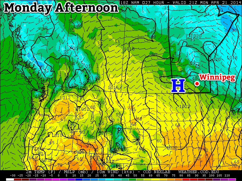
A surface high will bring pleasant conditions to southern Manitoba on Monday
Monday
Monday
9°C / -2°C
Mainly Sunny
Today will feature slightly below seasonal temperatures in southern Manitoba. Highs will range from the low teens in south-western areas, to upper single digits in the Winnipeg region. We’ll be under a surface ridge of high pressure, which should keep winds relatively light and skies relatively clear.
Tuesday
Tuesday
14°C / 4°C
Mainly Sunny
Tuesday looks to be another nice day in southern Manitoba. Temperatures should be near to slightly above-seasonal, meaning high temperatures in the low to mid teens. The wind will begin to increase late in the day, particularly over western Manitoba, as a developing weather system approaches the region.
Wednesday
Wednesday
9°C / 4°C
Mainly Cloudy. Chance of Rain.
Wednesday will see mild weather continue, with temperatures in the upper single digits, although we may get a bit wet. That developing weather system noted for Tuesday will spread rain, or even snow, into Manitoba on Wednesday. It’s too early to say where the main impacts of this storm will be, but it looks to become a fairly major storm for some part of Manitoba. Some of the current models take the storm up into Central Manitoba, while others take it through southern Manitoba. Areas to the north of its track could potentially see heavy snow, while areas to the south will see rain. As more certain information about this storm is available, we’ll be sure to let you know.
Long Range
The long range forecast suggests we’ll generally see normal to slightly-below normal weather to close out the month of April. That means high temperatures generally near the 10°C mark. While 10°C is nothing spectacular for this time of year, it certainly sounds ok given how awful the last several months have been.
A storm system pushing through Southern Manitoba tonight will bring snow, rain and everything in between to Southern Manitoba tonight, marking a significant shift in the upper-level flow that will bring seasonal to above seasonal temperatures through the weekend and into next week.
Friday
7°C / +2°C
Increasing cloud. Rain beginning this evening. 10-15mm.
Saturday
10°C / 0°C
Clearing in the afternoon; chance of showers.
Sunday
11°C / 0°C
Mainly sunny. Chance of showers overnight.
First Significant Rain of the Year
Today will be a pleasant day; high temperatures will sit around 6 or 7°C this afternoon with mainly sunny skies giving way to increasing cloudiness this evening. Winds will begin to pick up this afternoon to around 30km/h. The big story, though, is the low pressure system that will track through tonight.
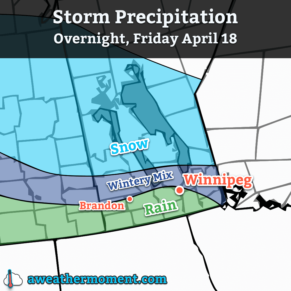
A major low pressure system will begin pushing into Southern Manitoba tonight. This system, marking the transition into a warmer weather pattern, will spread significant rain and snow through the province during the overnight hours. Things will start off in the afternoon through the Parkland region with snow spreading eastwards from Saskatchewan. As the system pushes towards the Interlake and Red River Valley, precipitation will extend southwards, primarily as rain and then push eastwards through the remainder of the night. Winds will also be fairly strong, with sustained winds around 30-40km/h and gusts up to 60km/h.
Multiple precipitation types will be coming into play again with this system. The primary rain-snow line, at this point, looks like it will sit 50-100km north of the Trans-Canada highway. This line is not set in stone, however, and will likely meander north and south as temperature profiles change and precipitation intensifies and subsides. Areas near the rain-snow line may see precipitation flip from one to the other multiple times. With this low pressure system freezing rain is not expected, but ice pellets or a rain/snow mix are entirely possible.
Expected precipitation types for tonight’s storm system.
Precipitation, while relatively short-lived, will be fairly intense with this system. The heaviest axis of precipitation looks to extend from Parkland Manitoba, through the southern Interlake and northern Red River Valley and then through SE Manitoba into NW Ontario. For those on the snow side of the rain/snow line in Parkland Manitoba (including Dauphin), snowfall amounts will peak at around 10-20cm with amounts tapering off towards the northern Interlake and the rain/snow line. For the areas that will see rain, amounts will be split into three main groups:
Location
Rainfall Amount
Extreme SW Manitoba (Melita)
<= 5mm
SW Manitoba & Southern RRV
5-10mm
Winnipeg/Northern RRV & SE Manitoba
10-15mm
Saturday will start off mainly cloudy with mist and fog scattered through the Red River Valley. There will be a slight chance of showers, particularly through the northern half of the valley through Winnipeg and into the Southern Interlake. For any activity that does occur, however, amounts will be fairly minimal. Winds will be relatively light and skies will begin to clear for a sunnier afternoon. The temperature will top out around 10°C.
Saturday night will see temperatures dip to around 0°C with light winds. It’s likely that the substantial precipitation coupled with rapid snow melt and calm winds will produce fairly extensive fog through the Red River Valley. Fog is notoriously difficult to predict, so we’ll keep tabs on things into the evening hours and try to give as much heads up one way or another as to what to expect. Just be aware that for travel overnight Saturday into Sunday, fog may play into the picture.
Warmer Weather Arrives
We’ll start pushing into the significantly warmer weather on Sunday as another low pressure system approaches, bringing with it another pulse of warm air. Temperatures in Winnipeg will climb to around 11°C on Sunday with light winds under mainly sunny skies[1]. Temperatures on Sunday night will drop to around 0°C once again, but we do have an ever so slight chance of seeing some showers overnight as a disturbance tracks along the U.S. border.
Daytime highs should sit near to just above normal through much of next week, generally in the 10-15°C range. No threats for precipitation are expected until the second half of the week.
If we end up with fog on Saturday night, we’ll see a cloudier Sunday morning, however skies should clear by late morning for a sunny afternoon. ↩
The GFS depicts an upper-level ridge building into our region early next week.
Winter-weary Winnipeggers can take solace in the fact that an end to the never-ending winter is in sight. There is increasing confidence that a large upper-level ridge will build into the Central U.S. and Southern Prairies early next week and finally bring some seasonal to slightly above seasonal temperatures to the region. First, though, we’ll have to make it through the rest of the week.
A Cold End to the Week
Cold temperatures will continue to persist through the remainder of the week with well below seasonal highs and lows expected. These cold temperatures are being caused by a large stationary trough of cold air over Hudson Bay that has locked the eastern Prairies into a northwesterly flow that has allowed cold Arctic air to spill southwards, dashing the warm-weather hopes of battered and beleaguered Manitobans.
Wednesday
-2°C / -17°C
A few clouds.
Thursday
0°C / -10°C
Partly cloudy. Slight chance of flurries.
Friday
5°C / 1°C
Late day cloudiness; warming up.
Tonight will be the coldest night for the remainder of the week in the Red River Valley thanks to another push of cold air on the back side of a low pressure system passing to our south. There will be a strong chance of another swath of record low temperatures broken – similar to Monday night – as overnight lows dip some 15-20°C below normal.
Thursday brings a similar high to today, around -2°C, however temperatures just off the ground will be a little bit cooler. This combination will result in stronger low-level instability and we could potentially see a few light flurries develop through the Red River Vally similar to what was seen on Monday afternoon. Overall the risk is very slight, though. Temperatures will drop to a more mild -10°C Thursday night as warmer air begins pushing eastwards.
Friday will be the warmest day so far this week. Temperatures look to climb above the freezing mark towards +4 or +5°C with only a bit of cloudiness to contend with. Winds will be a little breezy out of the southeast to around 20-30km/h, but overall it will be quite a pleasant day with plenty of sunshine. Some cloud will begin streaming in late in the day ahead of the next system pushing towards the region. The cloudier skies will help keep our overnight low fairly warm, with a chance we won’t even drop below 0°C. We may have to contend with some unpleasant weather through the overnight hours, though…
Big Shift on the Weekend
Precipitation amounts forecast on Friday night by the GDPS.
Models are all hinting towards some precipitation on Friday night into Saturday morning as a low pressure system lifts northeastwards through the Prairies. It’s still far too early to speak towards the system in much detail at all, other than saying the bulk of it looks to happen during the overnight period. Some models, such as the pictured output from the GDPS[1] really wind the system up and produce significant quantities of rain or snow while others lift the system much further north with little precipitation development. We’ll have more details on precipitation type and how much of what to expect later on in the week.
The bigger news is that this system marks a significant pattern shift as the upper level ridge we mentioned at the beginning of the article begins developing and pushing eastwards. As it does so, warmer air looks set to flood the Prairies, quickly launching our temperatures back towards seasonal to above-seasonal. Sunday will have temperatures close to normal[2] and we might see it get as warm as the low-to-mid teens on Monday, if we can manage to work past our snow cover.
Multiple days of near-to-just-above freezing temperatures coupled with the strong April sun should do quick work to melt the remaining snowpack across much of the Red River Valley. Melt will be minimal until the weekend, but even one or two days with temperatures in the 5-10°C range will do quick work with much of the remaining snow. Once we can eliminate the snow pack, extremely abnormal cold will be much harder to come by and it will be much easier to see seasonal temperatures.
Global Deterministic Prediction System – Canada’s long-term forecast model. ↩
Seasonal temperatures for Winnipeg currently are around 11°C for a daytime high and 0°C for an overnight low. ↩
This week will see one last wintry blast in southern Manitoba before spring finally arrives for good.
A surface ridge of high pressure will bring cold weather to southern Manitoba to start the week
Monday
Monday
-7°C / -18°C
Mainly sunny. Chance of flurries.
Today will likely be the coldest day of the week. High temperatures will be in the upper minus single digits, with a chance of flurries. This chance of flurries will arise from low-level instability that will develop as the surface warms during the day. To top it all off, there will be a breezy north-west wind – great!
Tuesday
Tuesday
-5°C / -15°C
Increasing cloudiness. Slight chance of flurries.
A low pressure system will pass to our south on Tuesday, allowing a cool north-easterly flow to remain established over southern Manitoba. Luckily, that system should remain far enough south to prevent us from seeing any more snow, although a couple of flurries can’t be ruled out.
Wednesday
Wednesday
-4°C / -17°C
Mix of sun and cloud. Chance of flurries.
A brisk northerly flow will remain in southern Manitoba on Wednesday, making for another cold day. High temperatures will be in the mid minus single digits, and there will once again be a chance of flurries.
Record Cold?
With the cold weather that’s expected this week, we will be challenging some cold weather records. The table below shows the record values for the next several days:
Record Cold Minimum and Maximum Temperatures
Date
Record Low
Record Cold High
Monday April 14
-16.7°C (1893)
-7.8°C (1880)
Tuesday April 15
-16.7°C (1893)
-6.7°C (1875)
Wednesday April 16
-16.7°C (1875)
-4.4°C (1910)
Thursday April 17
-13.3°C (1953)
-3.3°C (1953)
It looks like we will come close to setting new records on each of the days listed in the table. Stay tuned to see if we manage to actually break any records!
Long Range
The long range forecast calls for increasing temperatures as we move into the weekend. We’ll likely see seasonal temperatures (i.e. low teens) return by the weekend into next week. There is currently no strong prospective of above-normal weather, but we’ll probably see at least a couple seasonably warm days before the month is out.
Record Low Temperatures Broken
A large swath of record low temperatures were set on the morning of April 15, 2014 across the province of Manitoba thanks to a strong Arctic ridge of high pressure sprawled over the region. Overnight lows were 10-20°C below normal throughout the province. Winnipeg did not set a new record low, however some other locations in the Red River Valley did.
Record Low Temperatures set on April 15, 2014
Site
New Record
Old Record (Year)
Berens River
–23.8°C
–19.6 (1997)
Carberry
–14.2°C
–12.9 C (2000)
Carman
–15 C
–11.4 C (2000)
Fisher Branch
–20.4 C
–11.8 C (2000)
Flin Flon
–20.5 C
–16 (1997)
George Island
–19.5 C
–16.8 C (1997)
Grand Rapids
–24.4 C
–13 (1997)
Island Lake
–20.7 C
–20.6 C (2000)
McCreary
–13.7 C
–12 (2000)
Oak Point Marine
–19.7 C
–11.9 (1997)
Pinawa
–21 C
–12 (2000)
Roblin
–11.4 C
–11.3 C (1997)
Shoal Lake
–11.5 C
–10.2 C (2000)
Sprague
–16 C
–10.8 C (2000)
The Pas
–20.5 C
–18 C (1986)
Thompson
–27.3 C
–23.4 C (1985)
Victoria Beach
–20 C
–11 C (2000)
Wasagaming
–15.5 C
–15 C (1978)
More record lows will be at the risk of being broken as the week progresses.