Sunny skies will give way to clouds and a few scattered showers by midday today, but the threat will be short-lived as we move into a more stable, settled pattern for a brief reprieve from the wild weather of late. The calm weather won’t last too long, though, as more showers look to push into southern Manitoba on Friday.
24°C / 8°C
Becoming a mix of sun & cloud with a chance of midday showers.
24°C / 12°C
Sunny
18°C / 12°C
Showers likely.
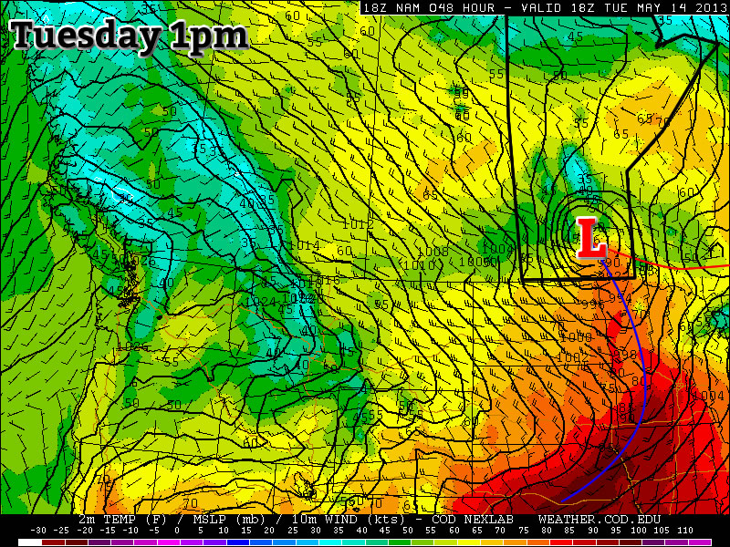
Today & Tomorrow

We’ll see a sunny start to the day today, but as we warm up some convection will begin to bubble up by late morning. Widespread showers are not expected; while some marginal instability will be realized, moisture will be a limiting factor and increasingly so through the day. A few scattered showers will likely develop along a trough line extending from Swan River southeastwards through Lake Manitoba and the Red River Valley midday and then die out in the early afternoon as any remaining available moisture mixes out. We’ll climb to a high of 24°C and drop down to around 8°C overnight under clear skies.
Thursday will be a beautiful day as we sit under the influence of a weak ridge. We’ll climb to a high around 24°C again with an overnight low of only around 12°C with increasing cloudiness overnight ahead of the next weather system.
Friday
The main weather story on Friday will be an area of rain or showers that moves into Southern Manitoba ahead of a shortwave pushing through Saskatchewan. An area of showers with possible embedded thunderstorms will develop through western North Dakota and spread northwards on Thursday night into SE Saskatchewan and western Manitoba along a 850mb low-level jet (LLJ). The LLJ looks to maintain it’s strength or even strengthen through the day on Friday, which should make it able to maintain the area of precipitation as it spreads eastwards.
At this point, it looks like showers will push into SW Manitoba overnight on Thursday night and spread into the Red River Valley on Friday morning. The showers should push out of the Red River Valley by mid-afternoon after producing, in general, around 5–10mm of precipitation. We’ll be left with a chance for some lingering showers in the afternoon/evening.
The Long Weekend
Continuing in a long and storied history of May long weekends in Winnipeg, the weather does not look very good for this coming weekend. As the showers push through on Friday, it looks like a potent weather system will be busily organizing itself and preparing to deluge Southern Manitoba.

A massive upper trough is forecast to move onshore from the Pacific Ocean this weekend, setting up a deep southerly flow that will transport large amounts of Gulf moisture northwards through the Great Plains into the Southern Prairies. A series of shortwaves is forecast to produce multiple shots of moderate rain and/or nocturnal convection. It’s still too early to get into specifics, but at this point it’s looking like it will rain over a majority of Southern Manitoba on Saturday, Sunday and Monday.
Different models currently have vastly different solutions: the GDPS[1] is forecasting absolutely unbelievable storm total precipitation amounts of anywhere from 5–10“ to upwards of 30”. This is impossible but does emphasize both the strength of the system and the amount of convection the GDPS is seeing. The NAEFS[2] is producing around 1–2“ of rain for most of Southern Manitoba. The GFS[3] is producing 2–3” of rainfall, but focused more over SE Manitoba with amounts diminishing westwards through the Red River Valley.
All in all it looks to be quite a rainy weekend. There are still plenty of details to be determined and we’ll take a much closer look at it for Friday’s post. We’ll leave a comment or two below with any interesting developments before then.