July to End on a Hot Note

July looks to end hot as temperatures remain near thirty degrees for the first two days of the week.

Temperatures will be in the upper twenties or near thirty in Southern Manitoba on Monday

Temperatures will be in the upper twenties or near thirty in Southern Manitoba on Monday

The month of July will end just as it started, very warm. Temperatures on Monday will be in the upper twenties in Southern Manitoba. On Tuesday highs are expected to be around thirty degrees in all of Southern Manitoba. There will be a risk of thunderstorms Tuesday, with Western Manitoba having the greatest chance of seeing a storm.

The first couple days of August are expected to remain hot as well. Highs on Wednesday and Thursday should once again be up near 30C. At this point models are hinting at the potential for a thunderstorm outbreak later this week across parts of the Prairies provinces. At this point it is too early to say how Manitoba might be affected by this upcoming weather system, but it is something to watch.

Pleasant Start to the Weekend

After a few days that threatened storms for the Red River Valley, we’re heading out the other side with most communities seeing little to no rain. Steinbach is a notable exception, with over 100mm of rain falling1 through a rather unusual rainfall event early Wednesday morning which produced significant overland flooding2.

24hr. Precipitation Totals valid Sunday Evening

24 hour accumulated precipitation from Friday Saturday evening to Sunday evening.

A pleasant start to the weekend is ahead, with no chance of showers until Saturday evening and overnight. Today we’ll see mainly sunny skies as our temperatures rebound from yesterday’s system up to a high near 26°C. The overnight low tonight will be around 15°C. Warmer air pushing in aloft will allow temperatures to climb higher on Saturday and Sunday, with daytime highs close to 30°C expected. Humidity will remain relatively low for Saturday, however things may get a little uncomfortable on Sunday as dewpoints begin to climb closer to the 20°C mark.

On Saturday a disturbance entering the province will generate some showers and thunderstorms over SW Manitoba through the late morning and afternoon hours. The (thunder)showers will spread eastwards through the evening and overnight, however it’s currently looking like the bulk of precipitation will occur through the Interlake. The northern half of the Red River Valley looks to have a decent chance of seeing some sort of precipitation, however the odds look very slim that the southern half will see anything.

We’ll see increasing cloud Sunday afternoon as the back side of this system prepares to swing through Sunday night. As it does, there will again be a chance of showers for Winnipeg and, as it looks now, the eastern RRV. We’ll be sure to provide updates in the comments as this system approaches.

new TWTR.Widget({
version: 2,
type: ‘list’,
rpp: 30,
interval: 30000,
title: ‘July 2nd, 2012’,
subject: ‘AWM Storm Chase’,
width: ‘auto’,
height: 500,
theme: {
shell: {
background: ‘#3c3c3c’,
color: ‘#eeeeee’
},
tweets: {
background: ‘#eeeeee’,
color: ‘#2c2c2c’,
links: ‘#489ce1’
}
},
features: {
scrollbar: true,
loop: false,
live: true,
behavior: ‘all’
}
}).render().setList(‘WeatherInThePeg’, ‘awm-team’).start();

Thunderstorm Risk Returns

The risk for thunderstorms returns to the Red River Valley today as a cold front with a history of producing severe weather pushes into the region.

850mb Analysis from the GFS

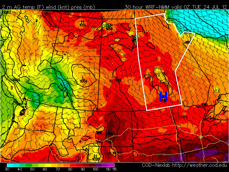
850mb Analysis from the GFS model for mid-morning today.

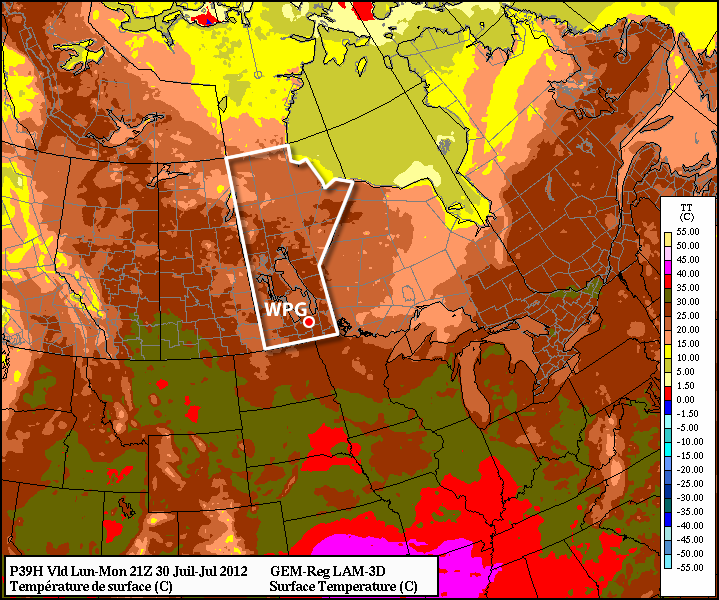
We’ll see some clouds/light showers clearing out early this morning across the Red River Valley, leaving us in sunshine for the latter half of the morning and early afternoon. By early afternoon, a cold front will be draped N-S over the western RRV. With temperatures climbing into mid-to-high 20’s by mid-afternoon, there should be enough heat and moisture to get storms going along the cold front. It’s likely, but not certain, that some thunderstorms will deveop on a north south line from near Winnipeg south towards the International Border. These storms will track eastwards across the RRV through the mid-to-late afternoon.

They will certainly have the potential to be severe. This cold front has a history of producing storms capable of damaging winds, large hail, and isolated tornadoes. For us, conditions don’t look quite as favorable as they did yesterday in SK or the day before in AB. We’ll be looking at:

  • 1000-2000 J/kg of CAPE
  • LI values near -7
  • Bulk shear values of only 20-35kt
  • 0-3km EHI values only 1-1.5

Wind shear will be the biggest limiter to storm development today. Storms may struggle to develop a distinguished structure, which could result in a relatively tame outcome. There’s just enough support to not be able to rule a severe storm out, however, and I expect we’ll likely see some watches issued for the RRV midday. The main threats for these storms will be heavy downpours with rapid rainfall accumulation and large hail. There’s a secondary threat of strong winds and, while tornadoes cannot be ruled out, the threat for the RRV is nowhere near the threat yesterday in Saskatchewan. Ultimately, though, the chance for seeing storms depends highly on the speed of the cold front; we’ll have to wait and see how quickly it moves into the RRV today to refine the thunderstorm forecast.

Things should clear out in the evening before a chance for showers returns late overnight and Thursday morning as the main upper low tracks over the RRV. We’ll see a mix of sun and cloud on Thursday with a high near 25°C. Friday heading into the weekend looks fairly nice. Sunshine should dominate and temperatures will climb back into the high 20’s or low 30’s. We’re certainly shaping up for another above-average month for temperatures. If July’s mean temperature is above normal, it will be the 13th consecutive month with above-normal temperatures in Winnipeg.

Dog Days of Summer

The weather has been very warm so far this July and there is no sign of this pattern changing any time soon. The dog days of summer are in full swing.

A surface high pressure system will help keep the weather warm and calm through Monday and Tuesday

A surface high pressure system will help keep the weather warm and calm through Monday and Tuesday

Temperatures on Monday will remain warm, but will be fairly comfortable. High temperatures in Southern Manitoba will generally be in the upper twenties with low humidity. Tuesday should be a bit warmer than Monday, with highs near thirty degrees, but once again humidity levels will remain relatively low. By Wednesday the humidity will rise ahead of an approaching trough of low pressure. At this time it appears that there may be a risk of severe storms on Wednesday afternoon and evening in the Red River Valley and South-Eastern Manitoba as this trough runs into a hot and humid airmass. However, the timing of the front is still a bit uncertain, and the speed at which is moves will determine which areas are at risk for storms on Wedensday.

At this point you can probably predict what next weekend has in store…yes you guessed it, more hot weather. It looks like we may be lucky enough to get one cooler day on Thursday, with high temperatures close to normal (i.e. in the mid twenties) before we heat up again for the last weekend of July.