Sunny and Warming Weather Ahead

It’ll be nothing but sunshine — and perhaps smoke — as temperatures warm up through the weekend.

RDPS 2m Temperature Forecast valid 21Z Sunday May 25, 2025
Warmer weather will build back in across the Prairies this weekend.

Today’s forecast will be one of the easier ones in a while…sunshine and warmer weather ahead!

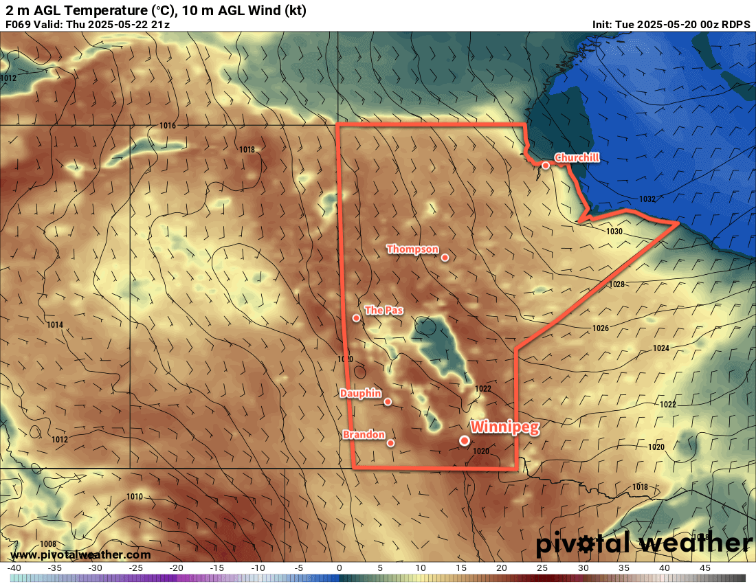
An upper ridge parked over the Prairies will keep an area of high pressure entrenched over Manitoba through the coming days. This will keep skies mainly sunny in the days ahead with light winds that shift around as the main axis of high pressure shifts its position through the weekend.

Daytime highs will sit in the 20–25 °C range this weekend with overnight lows in the 0—5 °C range warming up into the 5–10 °C range to end the weekend.

The biggest wildcard in the forecast will be smoke. The Nopiming Provincial Park wildfire has re-intensified and is pouring out substantial amounts of smoke, and there are other wildfires in southeastern Manitoba that have begun to perk back up. With light winds under the ridge in coming days, the smoke will likely pile up in the region, but who is impacted it will depend on the precise wind directions and how it changes over time.

It’s likely that the Winnipeg area will experience hazy conditions at times in the days ahead, and may see periods of degraded air quality with near-surface plumes of smoke moving through. For areas east of the Red River Valley, air quality will be very poor at times downwind of the Nopiming Provincial Park wildfire.

Long Range Outlook

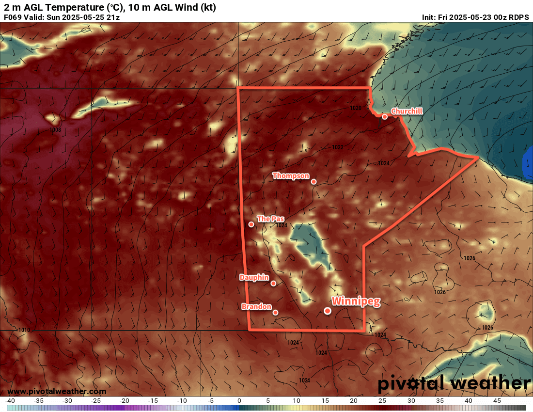
The sunny weather continues into next week, but temperatures will increase into the upper 20s as the week progresses.

All in all, while conditions are pleasant, the next week will do little to ease the fire danger in the province. Light winds will help, but one hopes we don’t see too many new fires flare up in the days ahead.

Today’s seasonal daytime high in Winnipeg is 21 °C while the seasonal overnight low is 7 °C.

Warming Up This Week

After one more cooler day, temperatures in Winnipeg will warm back up to seasonal values for the second half of the week.

RDPS 2m Temperature Forecast valid 21Z Thursday May 22, 2025
Seasonal temperatures will return to much of Manitoba by the latter half of the week.

Today will bring cloudy and cool weather to Winnipeg. The main weather feature will be a band of rain stretching from a low pressure system crossing the American Plains into southwestern Manitoba and eastern Saskatchewan. This will likely bring showers to the southern Red River Valley today while Winnipeg will have a chance of seeing rain if it ends up grazed by the eastern edge of the precipitation as it pushes northwest.

The cloudy weather will come alongside easterly winds of 20–30 km/h and a high in the mid-teens. Rainfall totals will likely range from anywhere from as much as 10 mm of rain over the far southwestern Red River Valley to a trace of rain further northeast.

Temperatures will dip down into the mid-single digits as the cloud cover breaks up overnight.

Wednesday will bring a building ridge of high pressure into the region. This should bring partly cloudy skies to the region with light easterly winds. With more sunshine, temperatures will climb higher than today, topping out in the upper teens. Wednesday night will bring clear skies and temperatures dipping down into the mid-single digits.

Thursday will bring mainly sunny skies and a high near 20 °C. Winds will pick up out of the northeast to around 20 km/h for much of the day. The winds will shift southeast overnight as temperatures head to a low in the 5–10 °C range.

At this point, it doesn’t appear that smoke will be much of an issue in the days ahead. The recent rain and cooler weather has dampened the fire activity in southeastern Manitoba. We’ll monitor the fires through the week as conditions dry out and the weather begins to warm again.

Long Range Outlook

The weather looks benign into the weekend the weekend with variable cloudiness and highs hovering near the low 20s. Overnight lows will sit in the 5–10 °C range.

A push of warmer weather along with a chance of showers or thunderstorms is possible later next week.

Today’s seasonal daytime high in Winnipeg is 21 °C while the seasonal overnight low is 6 °C.

A Very May Long Weekend Ahead

After a brief heat wave that brought deadly fires to parts of southeast Manitoba, things will shift to the polar opposite for the long weekend.

ECMWF 24-hour Precipitation Accumulation valid 12Z Saturday May 17, 2025
A swath of accumulating rain will fall across southern Manitoba on Friday with a further 5 to 20 mm across the region.

There’s no beating around the bush, it’ll be a miserable day in Winnipeg today. As a potent low pressure system meanders through North Dakota and Minnesota, it will continue to wrap rain into the province while driving a cold front south. It will be a rainy day in Winnipeg today with strong northerly winds developing. Temperatures will fall into the mid-single digits this afternoon as those winds gust as high as 70 to 80 km/h.

Rainfall totals will vary across the Red River Valley, but accumulations will broadly fall into the 10 to 20 mm range with localized pockets of higher and lower accumulations. The main swath of rain will stretch from east of the south basin of Lake Winnipeg southwest through the Red River Valley. The rain will gradually taper off on Friday night as temperatures head down to a low near +2 or +3 °C.

Saturday will be a cold May day with northerly winds up to 40 gusting 60 km/h and a high temperature that struggles to climb into the 5 to 10 °C range. Skies will stay cloudy through the day. Temperatures will drop into the 0 to 5 °C range on Saturday night under cloudy skies. A ridge of high pressure building into the region will finally bring an end to those moderate northerly winds.

Sunday will bring more cloud cover to the region, but sunshine may poke through later in the day. Temperatures will climb to around 10 °C with east winds around 20 km/h. Skies will clear out for Sunday night with a low in the 0 to 5 °C range.

A Note on Smoke

Over the coming days (and weeks?) wildfire smoke will be an occasional concern for the region. Multiple large fires are now burning in southeast Manitoba and northwest Ontario, and their smoke plumes will move towards the region in any easterly or northeasterly wind. That said, it will be complicated to forecast for as the relative closeness of the fires means that depending on the conditions the plumes may be widespread in coverage or they may be narrow bands that stretch downwind of the fire.

Complicating things more will be the need to wait and see how the fires respond to this weekend’s rain and cooler temperatures.

All that to say that wildfire smoke may be a concern at times in the weeks ahead, if not for much of the summer. Moreover, these fires are ripping through cottage country, likely impacting someone you know.

The best thing that could happen is a stretch of cooler weather with frequent rain; we’ll see what happens in the weeks ahead.

Long Range Outlook

Heading into the start of next week, it looks like temperatures will gradually climb back towards seasonal values with mainly sunny skies. At this point it doesn’t look like there will be much chance for precipitation through the week.

Today’s seasonal daytime high in Winnipeg is 20 °C while the seasonal overnight low is 5 °C.

Scorching Heat to Give Way to Unsettled and Much Cooler Weather

The scorching heat and dangerous fire conditions will persist in Winnipeg and the Red River Valley for another day before the heat shifts east and showers and thunderstorms move into the region.

RDPS 2m Temperature Forecast valid 21Z Tuesday May 13, 2025
Tuesday will bring another day of scorching heat and dangerous fire conditions in southern Manitoba.

Winnipeg will be off to a hot start today with temperatures in the low 20s that quickly climb to 30 °C by lunch. Southerly winds will pick back up to 40 gusting 60 km/h as temperatures continue to climb to a high in the mid-30s. Relative humidity will again drop below 20% today, which coupled with the heat and moderate winds will pose another risky fire weather day for the region. There will be a slight chance of an isolated evening shower or thunderstorm, but nothing substantial is expected for the region. Temperatures will head to a low in the mid-teens tonight with winds shifting to the north and easing.

On Wednesday, an upper low will shift from Idaho into southern Saskatchewan. As it pushes into the region, it will support a broad area of showers and thunderstorms that move from southeast Saskatchewan into western Manitoba and across the Interlake region. This broad area of cloud and rain showers will intensify the temperature change across a warm front draped southwest-northeast across southern Manitoba. Over a short distance, temperatures will change from around 30 °C on the warm side of the front to the upper teens on the cold side of the front. Right now, Winnipeg is forecast to sit barely on the cold side of the front with a high in the mid-20s, but small changes in the position of that front may change the daytime high by 5 °C or more.

Showers and thunderstorms will blossom across Manitoba on Wednesday night, but much of the activity looks to move through west and north of the Red River Valley. Temperatures in Winnipeg should dip down into the mid-teens on Wednesday night with cloud cover beginning to move into the area.

On Thursday, the unsettled weather will shift east into the Red River Valley as a pair of shortwaves lift north out of the Dakotas towards southern Manitoba. Temperatures will peak in the low 20s as more cloud and scattered showers and/or thunderstorms push through the region. with moderate northwest winds up to 40 gusting 60 km/h developing through the day.

On Thursday night, unsettled showery conditions will likely transition to periods of rain as temperatures continue to cool and a much broader, more organized low pressure system develops. Temperatures will dip down into the mid-single digits overnight with moderate northwesterlies continuing.

Long Range Outlook

Heading into Friday, periods of rain will continue through the day as more cold air pushes into the region. Temperatures will hold steady or even fall through the day, potentially dropping as low as +1 or +2 °C. Heading into Friday night, temperatures may drop to freezing, and precipitation over the region could turn into a wintery mix of rain and/or snow with a risk of freezing rain. Those northwest winds will continue through the night.

Heading into the weekend, the precipitation looks to gradually taper off on Saturday with a high in the low single digits and easing winds. Temperatures may dip below freezing on Saturday night. Cloudy skies will likely stick around into Sunday with a warmer high in the 5 to 10 °C range.

Temperatures will slowly trend towards seasonal values this week, but another disturbance mid-week may bring more rain to the region and keep temperatures seasonably cool through the week.

Today’s seasonal daytime high in Winnipeg is 19 °C while the seasonal overnight low is 5 °C.