Where’s Winter?

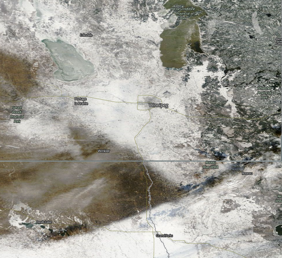
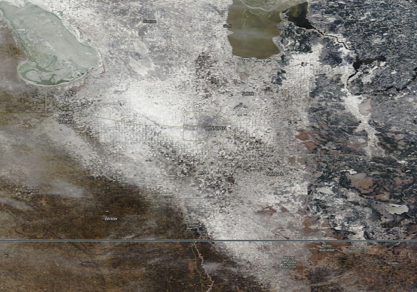
Winter will remain absent this week as temperatures remain well above seasonal and our meager snowpack continues to melt.

Today will remain well above normal for early December, as high temperatures across all of southern Manitoba remain near or slightly above zero. In the Winnipeg region, high temperatures are expected to creep just above the freezing mark, although skies are expected to remain mainly cloudy throughout the day. Winds will be breezy from the south at 20-30km/h.

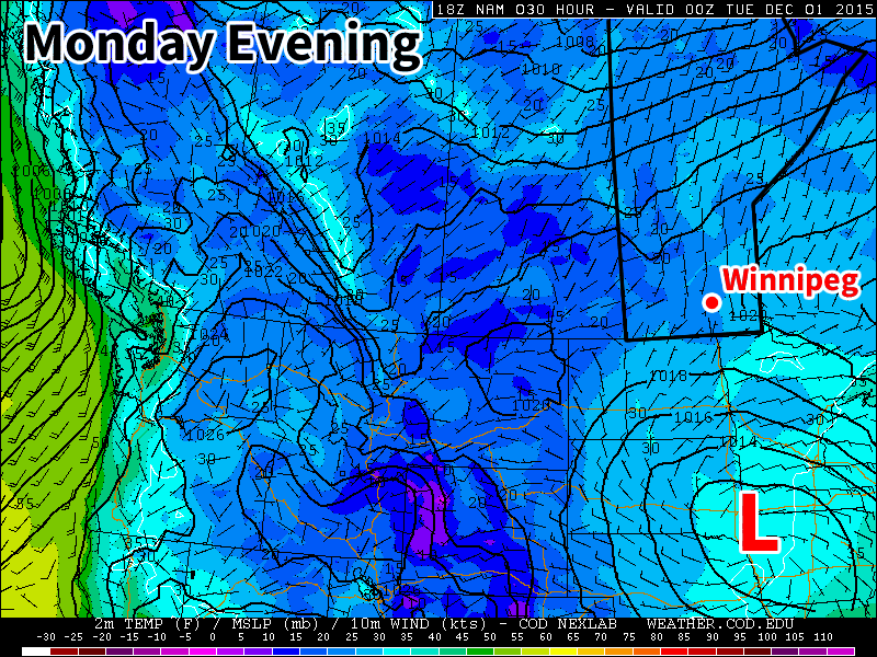
Tuesday will once again be seasonably mild, with high temperatures near or just above freezing. A weak low pressure system will pass through or just south of southern Manitoba, potentially bringing some light rain or snow to some areas. Given the warm temperature profile, any snow that falls is unlikely to accumulate to much. On the other hand, if we see a bit of rain it will only aid the snowmelt.

MODIS (Aqua) True Colour Satellite for December 6, 2015
Yesterday’s MODIS imagery clearly shows the diminishing snow pack over the Red River Valley.

Wednesday will see temperatures climb above freezing in southern Manitoba, perhaps well above zero in snow-free areas. In the northern Red River Valley, high temperatures will only be a few degrees above freezing. Winds will be breezy from the south at 20-30km/h.

Long Range

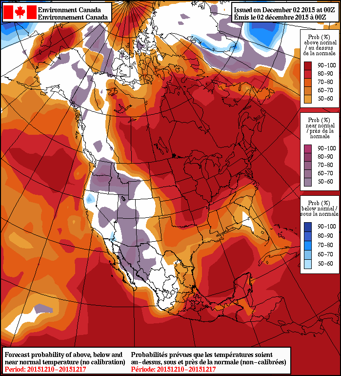
Models continue to show above-seasonal weather for the foreseeable future. However, after this week temperatures may not be quite as warm as they’ve been of late. The average high temperature at this time of year is -8C and the average low is -18C, so don’t expect temperatures to drop much below those values through the first half of December – particularly if we remain generally snow-free. The lack of snow reduces the reflectivity of the surface, allowing more sunlight to be absorbed, generating more heat in the lower atmosphere. So long as we don’t have snow on the ground over much of the southern Prairies, we will maintain a built-in bias toward warm conditions.

Exceptional December Warmth Continues

The warm weather bathing over southern Manitoba shows no end in sight as daytime highs above freezing will remain in place for the next week, absolutely rocketing past the seasonal high temperatures near -8°C.

The coming days will be dominated by a broad zonal flow over the southern Prairies that will maintain the unseasonal warmth over the region and continue to keep the Arctic air bottled up north. Mainly sunny skies over the coming days will help produce daytime highs near 3 or 4°C, some 10°C above normal for this time of year.  While we likely won’t be hitting record high temperatures—which range from +5-12°C for the coming days—this period of warmth is nonetheless remarkable for early December.

For the coming days, temperatures will remain at least 8°C above normal for this time of year.  The prolonged period of warmth will result in a gradual erosion of the snowpack over the majority of the Red River Valley.

MODIS (Aqua) True Colour Satellite for December 3, 2015

With little-to-no snow in the forecast, there’s a decent chance that by the start of next week, there’s a lot more bare ground showing around the Winnipeg area.

Other than the warm temperatures, there’s little to talk about in the forecast.  Today will be a fairly windy day with southerlies increasing through the day to around 40-50 km/h this afternoon. Winds will subside tonight and remain relatively light through the weekend. Overnight lows will sit in the -2 to -4°C range.

Long-Range Outlook

Nothing but warmth.

Both the NAEFS and the CPC show very high probabilities of above-normal temperatures continuing through the coming week or two. Little-to-no precipitation is expected.

Enjoy the beautiful weather!

Beautiful Start to December Continues

Beautiful Start to December Continues

A foggy start today will be the minor blip in what looks to be a beautiful second half of the week, and start to meteorological winter, as the mild weather shows no end in sight.

The forecast for the remainder of the work week is pretty straightforward: beautiful with warm and sunny weather.

This morning will be the one blip over the next few days as fog over the region gradually burns off. After that, we’ll see mainly sunny conditions over the coming days with temperatures slowly warming as a train of low pressure systems tracking across the Northern Prairies drag warmer air eastwards across the Prairies.

Winds will be calm today, however pick up through the remainder of the week. Thursday will see westerly winds around 20–30 km/h while Friday will see gusty southerlies at 30–40 km/h.

By Friday, daytime highs will be 10°C or more above seasonal values with the potential for substantial snow-melt through much of the Red River Valley.

Weekend Outlook & Beyond

The mild weather will continue into the weekend with daytime highs slightly above 0°C expected throughout much of the Red River Valley. Saturday will likely be the nicest day of the week with daytime highs of 2–4°C and some breezy westerlies. Sunday will be a bit cooler with lighter winds.

NAEFS 8-14 Day Temperature Anomaly Forecast valid December 10 to 17th, 2015

Looking further ahead, the NAEFS continues to remain very confident in above normal temperatures for the region. With no indication that the Polar Jet has any plans to shift further south, out of the Northern Prairies, it seems fairly safe to go with the NAEFS forecast. Early indications are that we can expect daytime highs next week in the range of –2°C to +2°C or so with little in the way of precipitation.

Pleasant Week Ahead

Pleasant weather is on tap this week as we see a fair amount of sunshine and above-seasonal temperatures.

A low pressure system will sit just south of Manitoba early in the week

Monday

Today will see mainly sunny skies and mild temperatures. The daytime high will be just below zero with light southerly winds. A strong low pressure system will be bringing precipitation to portions of the Dakotas and Minnesota early this week, so you’ll want to check the forecast if you’re heading south.

Tuesday

Tuesday will see much the same weather as Monday. Skies are expected to remain mainly sunny, with high temperatures in the mid single digits. If the system to the south pushes a bit further north we may see more cloud cover, but that is not expected to be the case at this point. Winds will be north or north-westerly at 20 km/h.

Wednesday

Wednesday will once again feature mainly sunny skies and mild temperatures. Temperatures will be just below zero, with breezy southerly winds at 20 km/h.

Long Range

The long range forecast continues to strongly suggest above-normal weather for the first half of December. The current weather pattern over North America is very typical of El Nino, with warm conditions across the western half of Canada and an active storm track across the southern US. Expect this pattern to continue as we move further into winter.