Unsettled Weather Shifts Towards Sunnier and Warmer Conditions For The Weekend

Thunderstorms will be possible for another couple days across southern Manitoba. By the end of the week, an upper ridge moving across the Prairies will bring calmer, warmer weather to the region.

NSSL-WRF Simulated Reflectivity Forecast valid 22Z Tuesday June 27, 2023
Scattered thunderstorm activity is expected to develop across southern Manitoba and North Dakota this afternoon.

The weather over the next few days will be driven by a disturbance slumping southeastwards across the Prairies into southern Manitoba. As it dips southwards, its cool air aloft will encounter a warmer air mass with more moisture in it. These two features combined will result in a couple days of unsettled conditions over southern Manitoba.

Today will start out with a chance of showers or thunderstorms in the general Winnipeg area; while it’s a bit uncertain as of writing, lingering instability combined with the northward push of a warm front could be enough to trigger some morning convection. If it develops, it should push eastwards out of the area through the morning hours.

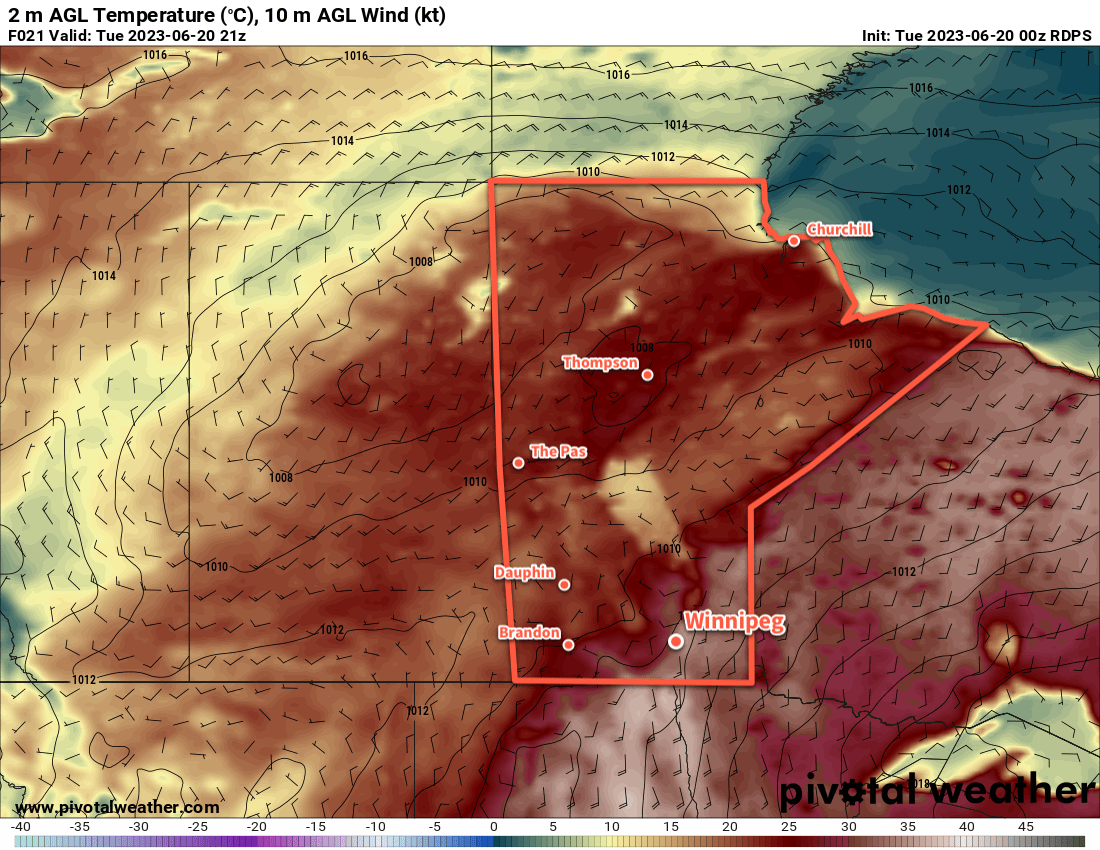
Once any morning convection clears out, it won’t take too long for things to get cooking. With mixed skies, most areas will see temperatures climb into the upper 20s fairly quickly. By early afternoon, scattered convection will likely begin to develop across southern Manitoba. With moderate instability and limited wind shear — around 1,000–1,500 J/kg of MLCAPE and 15–25 knots of bulk shear — there will be a risk of severe thunderstorms but it’s not looking like a widespread severe weather day. The most likely area for severe weather will be northwest of Winnipeg, especially in Parkland Manitoba and along the escarpment areas, but there is a small risk of an isolated severe thunderstorm in areas further southeast like Winnipeg.

The biggest unknown with the afternoon convection will be (a) if/where morning thunderstorms develop and (b) what the strength of the cold pool they may leave behind would be. That cold pool could work both ways, limiting thunderstorm development over it, but also acting as a focus along its boundaries to help trigger thunderstorm development.

Much of the activity will diminish tonight with temperatures heading down to a low in the mid-teens. There’s a small chance of an isolated shower or thunderstorm by early Wednesday morning.

On Wednesday, the upper low will dip through southern Manitoba, bringing similar instability, slightly better shear, and less inhibition of thunderstorm development. Scattered thunderstorm activity will develop across the region on Wednesday with mixed to cloudier skies. There will again be a risk of isolated severe thunderstorms.

By Thursday, the upper low will beginning to exit the province. Behind it, an upper ridge will be building eastwards across the Prairies. Skies will likely be mixed and there’s a chance a few showers might linger into the day, but things should really begin to clear out by the afternoon. Temperatures will be a bit cooler in the wake of the upper low with highs in the low to mid-20s. Skies will clear out on Thursday night with temperatures heading to a low in the mid-teens.

Long Range Outlook

The upper ridge will continue to build into the province for the end of the week, bringing sunny skies and warm weather. Temperatures will climb into the upper 20s for Friday, Saturday, and Sunday with relatively light winds shifting from northerly to westerly through the days.

Early indications are that a disturbance will begin working its way into the province later Sunday, bringing a chance of thunderstorms on Sunday night into Monday.

Today’s seasonal daytime high in Winnipeg is 25 °C while the seasonal overnight low is 12 °C.

Severe Thunderstorm Threat Followed By More Unsettled Weather

Hot and humid weather over southern Manitoba will lead to a thunderstorm outbreak on Tuesday afternoon. A cold front will slowly push across the region on Wednesday, bringing more showers with a risk of thunderstorms again, though severe weather is less likely. One last blast of unsettled weather will develop Thursday evening in North Dakota and spread into Manitoba overnight. By Friday, Winnipeg will see some more settled conditions.

RDPS 2m Temperature Forecast valid 21Z Tuesday June 20, 2023
It will be another hot day over the Red River Valley with highs in the 30s with dew points climbing over 20 °C.

There is a notable severe thunderstorm threat today in southern Manitoba as a hot and humid air mass continues building into the region. The main drivers of the weather today will be a warm sector trough that will arc from north-central North Dakota into the Interlake this afternoon and a cold front that is gradually shifting eastwards from the Manitoba/Saskatchewan border.

Along and east of the trough — which includes the Red River Valley — very hot and humid conditions will develop today. Daytime highs will climb into the low to mid-30s with dew points climbing up to around 20 °C. This will produce widespread humid values in the upper 30s or low 40s across much of south-central and southeast Manitoba. As this air mass cooks, it will bump up against the warm sector trough as it slowly shifts eastwards through the day.

By mid-afternoon, very significant amounts of energy for thunderstorm development will have built up in southern Manitoba. A quick summary of the afternoon’s convective parameter forecasts: MLCAPE values in the 2,000–3,000 J/kg range, bulk shear values of 25–45 knots, shear vectors aligned roughly along the convergence boundary, and STP values ≥ 1.

NSSL-WRF Forecast MLCAPE valid 21Z Tuesday June 20th, 20233km NAM Simulated Reflectivity valid 02Z Wednesday June 21, 2023
The NSSL-WRF model (left) shows clearly the axis of significant instability that develops on Tuesday afternoon. By 7PM CDT, thunderstorms will begin to develop and quickly grow into a complex of [potentially severe] thunderstorms within a couple hours (right).

The end result of all the parameters is this: thunderstorms will redevelop this afternoon and there will be numerous severe thunderstorms. Primary threats today will be very large, damaging hail and torrential rain. With so much energy to work with, it’s also likely that some thunderstorms will be able to produce damaging wind gusts. An isolated tornado or two is possible today, particularly early in the storm development later today.

Be sure to be aware of any severe weather watches or warnings issued by the Meteorological Service of Canada through the day today.

The thunderstorm activity will continue into the night, growing upscale along the trough and slowly shifting eastwards. Activity will refocus further south overnight where another disturbance riding northeastwards along the cold front, spreading more showers with the risk of thunderstorms into southern Manitoba by Wednesday morning. With the cold front further east, Winnipeg will see cloudier conditions through the day but temperatures could still be quite warm with highs in the upper 20s. Thunderstorm activity on Wednesday will be weaker overall than today, with a much lower risk of any severe-level activity.

More rain and thunderstorms is possible overnight Wednesday into Thursday as another disturbance rolls into the province along the slow-moving frontal boundary. It will support an area of nocturnal convection that will push into southern Manitoba, bringing what could be another widespread area of precipitation. There will be much less instability by this point, so little to no severe weather is likely with this final round of showers. This system will also bring cloudy skies to the region for much of Thursday with highs finally dipping back down into the mid-20s. The humidity stuck in the region will also finally begin to ease as the cold front slowly shunts southeastwards.

Long Range Outlook

More unsettled weather is likely this weekend as an upper low treks northeastwards out of the American Rockies, bringing a broad area of rain into southern Manitoba. There’s still some uncertainty associated with this system, but at this point it looks like a widespread 25 to 50 mm could be possible across many parts of southern Manitoba through a combination of rain and embedded thunderstorm activity. This system will clear out of the region to start next week, followed by another chance of showers on Monday evening as a cold front slumps into the region.

All in all quite an unsettled week ahead of us with numerous chances for showers and thunderstorms across the region. Particularly today, be sure to keep aware of the day’s thunderstorm development given the notable risk of severe weather.

Today’s seasonal daytime high in Winnipeg is 24 °C while the seasonal overnight low is 11 °C.

Seasonal Temperatures With a Chance of Showers

Seasonal temperatures will persist in Winnipeg for a couple more days with a chance of showers as a couple disturbances pass through the region.

RDPS 300mb Height and Wind Forecast valid 18Z Saturday June 17, 2023
This small shortwave and associated jet streak (blue/purple shading) entering southwest Manitoba on Saturday is the source of much uncertainty for the day’s weather.

Temperatures will climb to a high near 20 °C today as a slow-moving front begins nudging its way into the Red River Valley. It will bring a slight chance of some showers with it, but none of them will likely be particularly intense and no widespread rain will come from this system. The cloud cover will break up a bit for the evening, then temperatures will dip into the low teens overnight.

On Saturday, some more showers are possible as an upper-level disturbance pushes across the region. There’s still some uncertainty on this one with very divergent solutions between Canadian and American weather models. The Canadian forecasts are producing an area of rain that will push across the region midday into the afternoon. The American models, on the other hand, keep it dry. Personally, I’m hoping for the dry solution for an event on the day, but it’s really a toss-up right now. Things will become much more apparent later today when it materializes well to our southwest and we can see what it’s able to start producing.

Aside from that, Winnipeg will likely see mixed to cloudy skies on Saturday with a high in the low to mid-20s. Skies will clear out overnight with temperatures dropping into the mid-teens.

On Sunday, heat will begin to build back into the region. Temperatures will climb back into the upper 20s under mainly sunny skies. Humidity levels will stay comfortable, making for a beautiful summer afternoon.

Long Range Outlook

Next week will continue the trend of warm weather with daytime highs in the low 30s gradually easing into the mid- to upper-20s.

Unlike the last bout of heat we experienced, this warmth will be the response of a deep upper trough digging southwards along the west coast. As a result, conditions will become fairly unsettled next week over the southern Prairies with several disturbances tracking through that will bring a risk of thunderstorms to the region.

The main risk should primarily stay to the west and north of southern Manitoba through the first half of the week, but stormier weather is likely in the second half of the week.

Today’s seasonal daytime high in Winnipeg is 24 °C while the seasonal overnight low is 11 °C.

Cold Front Brings Relief From Hot and Humid Weather

A cold front passing out of the province today will usher a cooler and drier air mass into southern Manitoba. This will bring a welcome break from the hot and humid early-June weather the region has seen, along with more settled conditions.

RDPS 2m Temperature Forecast valid 21Z Saturday June 10, 2023
On Saturday, a high pressure centre moving in from the north will bring cooler daytime highs in the low 20s to southern Manitoba.

A cold front will sweep through southern Manitoba this morning, bringing some cloud, a slight chance of showers or thunderstorms, and a breezy northerly wind. In Winnipeg, any chance for rain should end by midday, leaving dry conditions and a high in the mid-20s. Unfortunately, the city won’t see clear skies in the afternoon; behind the cold front, smoke from the northern Prairie forest fires will push into the region. It may end up being fairly noticeable for a few hours after the passage of the cold front, otherwise it should mainly appear as haze and not have too significant an impact on air quality. The winds will ease in the evening, then temperatures will head to an overnight low in the low teens, the coolest in a while.

Through the weekend, a large area of high pressure will settle into the region. Saturday and Sunday won’t bring cloud to the region, rather it will largely just be a question of how much smoke lingers over the region. Temperatures will be cool on Saturday with a high in the low 20s and a low near 10 °C. Temperatures will begin to warm on Sunday with a high back in the mid-20s and a low in the mid-teens.

Long Range Outlook

To start next week, daytime highs will once again climb back to around 30 °C. The humidity levels will stay much lower and keep the heat a bit more comfortable than last week. By mid-week, conditions could turn unsettled again and bring the chance of showers or thunderstorms to the region for several days.

Today’s seasonal daytime high in Winnipeg is 23 °C while the seasonal overnight low is 10 °C.