Fall Starts By Putting Summer to Shame

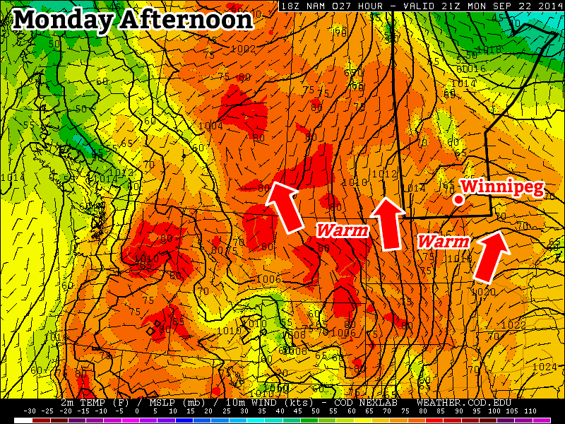
The first week of fall[1] will start off with weather that will seemingly put this summer to shame. Very warm weather is on the way with potentially record-breaking highs across Southern Manitoba on Thursday!

Wednesday
25°C / 14°C
Cloudy; clearing for a sunny afternoon

Thursday
31°C / 16°C
Mainly sunny; increasing humidity

Friday
30°C / 16°C
Mainly sunny & hot

A prominent upper-level ridge in place over the Prairies has pushed the polar jet stream far northwards and allowed warm air to spread into the Southern Prairies from the United States. As a result, significantly warmer than normal temperatures will continue through the remainder of the week in Winnipeg.

Today will start off fairly cloudy thanks to some stratus cloud that spread northwards ahead of a dissipating trough of low pressure. The cloud should clear out for the afternoon and we’ll see temperatures climb to around 24 or 25°C. The temperature will dip to around 14°C tonight under mainly clear skies.

Thursday and Friday will both bring highs just at or over the 30°C mark under mainly sunny skies. South to southeasterly winds will begin tapping into some moisture from the Central Plains of the US and we’ll see the humidity gradually rise for the latter half of the week. Dewpoint values will climb into the mid-to-upper teens, which when combined with highs near 30°C, it will feel more like the mid-to-upper 30’s. The overnight lows both nights will be in the mid-teens.

Record-Breaking Potential

We have a slight chance of breaking daily record high temperatures on both Thursday and Friday. For Thursday, September 25th the daily record high temperature is 31.1°C set in 1950. For Friday, September 26th the daily record high temperature is 31.7°C set in 1957. Both days will see temperatures climbing to or just above the 30°C mark, and if maximum heating is realized, we may get the bump we need to break one of these records!

Date High Temperature (2014) Record High
September 25 27.7°C 31.1°C (1950)
September 26 30°C (Forecast) 31.7°C (1952)

Cooler Weekend

The weekend is looking great, despite a cool-down that’s in store. Daytime highs will dip around 5°C or so for the weekend with both days seeing highs in the mid–20’s. Fortunately this still puts us around 8°C above normal for the time of year, so there will be little to complain about. We’ll likely see a bit more cloud that we do through the second half of the week, but all in all it will be a gorgeous weekend!


  1. …sort of. Meteorological fall started at the beginning of September, but fall as most people consider it began on September 22nd after the autumnal equinox.  ↩

Above-Normal Weather! Yes!

Above-normal weather is in store for us this week, it’s about time!

Warm weather is in store this week

Monday

Monday
24°C / 11°C
Mainly sunny

Today will be one of the warmest days we’ve seen in some time, with temperatures climbing into the low to mid twenties. Skies will be mainly sunny and winds will be breezy and from the south-west. It will be a very pleasant fall day, perfect for catching up on those outdoor chores that you may have been ignoring lately.

Tuesday

Tuesday
24°C / 13°C
Mainly sunny

Tuesday will not be much different from Monday. Temperatures will once again be in the low to mid twenties with mainly sunny skies. The wind will be gusty from the south, but it will still be a nice day. Unfortunately, that gusty wind will mean there will be a few leaves to start raking up, but that’s hardly reason to start complaining.

Wednesday

Wednesday
23°C / 14°C
Mix of sun and cloud

Another good day is in store for Wednesday. Temperatures will again be in the low to mid twenties. Skies will likely range from mainly sunny to a mix of sun and cloud. There will also be a gusty south wind, just like Tuesday.

Long Range

Long range models continue to show above-normal weather for the foreseeable future. In fact, we may see temperatures climb even higher by late this week into the weekend. This may be our last taste of summer weather, so enjoy it!

Elsewhere in Weather News: September 20th, 2014

Odile Makes Landfall

The active Eastern Pacific hurricane season that was discussed in the EIWN post a few weeks ago continues to produce – another major hurricane was spun up this week. This time it was hurricane Odile, a category four at its maximum strength, which bottomed out at a pressure of 922mb. This hurricane, however, headed towards the Baja Peninsula and made landfall there as a category three hurricane on Sunday night.

Odile just as it was making landfall on the tip of the Baja Peninsula. (Source: NOAA)

Cabo San Lucas was one of the resorts hardest hit as Odile brought winds of 205km/h upon landfall. As expected with a hurricane of this magnitude, significant damage was done to infrastructure as well as three deaths were reported. About 240,000 residents lost power during the event prompting school closures and flight cancellations; causing major headaches to travellers in the popular tourist destination. Odile eventually weakened into a tropical storm as it made its way further north, interacting with terrain and beginning to get torn apart by shear. Even though Odile had weakened substantially, the storm was not done causing trouble to people in the US Southwest, bringing with it its plume of tropical moisture. Reports of flooded houses and washed out roads were coming out of southern New Mexico and Arizona on Thursday and Friday where as much as 100mm fell in some towns (Sept. average rainfall is around 30-50mm in the region). Streams quickly became rivers and one resident perished as he got swept away by the floodwaters. It’s not all bad news to the US Southwest though, as drought continues to improve in the region.

Damage at the Los Cabos Airport. (Source: Reuters via Dailymail)

There’s already another storm; Polo, churning in the East Pacific but it is not expected to take the same path as Odile did. No other tropical storms are expected to impact the Baja Peninsula in the near future.

Warm & Unsettled Weather

The weather over the next couple days will be two things: warmer than normal for this time of year and somewhat unsettled. While no major rain-makers are expected, a couple rounds of showers will make for some damper spells. Fortunately, daytime highs near 20°C will be above the seasonal 17°C through the weekend!

Friday
22°C / 12°C
Mixed skies; chance of showers or thunderstorms

Saturday
20°C / 10°C
Mixed skies; chance of showers or thunderstorms

Sunday
20°C / 10°C
Mainly sunny

Today will bring mixed skies to Winnipeg as a broad trough of low pressure works its way across the province. There will be a slight chance of showers this morning if any of the overnight activity manages to linger on and/or push far enough north, however nothing significant is expected. We’ll see mixed skies heading into the afternoon with a high near 22°C with winds tapering off to light.

The RDPS is forecasting a line of thunderstorms along the advancing cold front this afternoon.

Later in the afternoon the threat of showers or thunderstorms returns as a weak cold front begins slumping southwards. Severe weather doesn’t look likely, although if stronger thunderstorms manage to develop some marginally severe hail could be a possibility.[1]

Skies will clear out a bit in the evening and we’ll be left with partly cloudy skies on our way to a low of around 12°C.

Saturday will start off with just a few clouds around. We’ll warm up to around 20°C for an afternoon high with winds gradually increasing out of the west-northwest to around 20–30km/h. By mid-to-late afternoon the threat for shower or thunderstorm activity will increase as a shortwave sliding down in the northwest flow aloft begins triggering activity over Parkland Manitoba and the Interlake. That activity will slide southeastwards through the afternoon into the evening with scattered showers or thunderstorms looking fairly likely.

This map of a feature called vorticity – essentially a measure of spin – shows a potent shortwave moving across Southern Manitoba on Saturday afternoon.
This map of a feature called vorticity – essentially a measure of spin – shows a potent shortwave moving across Southern Manitoba on Saturday afternoon.

Some thunderstorms may be surprisingly strong given the relatively meagre convective indices for the day. The key will be the favourable storm-relative winds in place. Suitable turning will be in place that it’s possible — not necessarily likely, but possible — for an isolated supercell or two to develop with strong winds and large hail being the primary threats.

Skies will clear out on Saturday night as we drop to around 10°C.

Sunday will be a nice day with not a whole lot to say about it! A ridge of high pressure moving into the province will bring clear skies and relatively warm temperatures with a high near 20°C. The temperature on Sunday night will drop to around 10°C.


  1. Environment Canada considers severe hail to be 20mm or larger in diameter.  ↩