Elsewhere in Weather News: July 27th, 2013

France Faces Severe Storms; More Coming Today

France has had its fair share of severe storms this past week, with more of it expected to come today (Saturday). A level 3 “severe” thunderstorm, the highest risk possible, has been issued by ESTOFEX (European Storm Forecast Experiment) for the northern half of France. Conditions are favorable for tornadoes with a warm front draped across the region and incoming cold front from the west; an upper-level low spinning off the coast of France over the Atlantic will provide sufficient destabilization in the upper levels of the atmosphere.
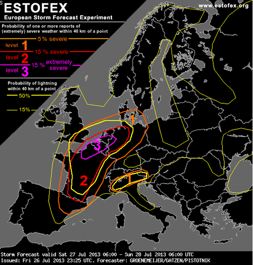
ESTOFEX forecast

ESTOFEX forecast for today, risk 3 in northern France, Belgium, Netherlands and northwest Germany. Highest risk for large tornadoes resides here. (Source: ESTOFEX)

The only potential flaw in the setup could be due to the large MCS that fired up on Friday evening in west-central France as it continues to move northeast potentially leaving debris cloud in the region this morning. But with that said, as of Friday evening, the MCS was moving fairly quickly, and at this rate would be out of the region in time for tomorrow’s setup. With dewpoints in the low twenty Celsius range, shear plentiful with the approaching upper-level trough, and a great shear profile, all kinds of severe weather could be in play, including powerful tornadoes. The severe weather risk also extends into northwest Germany, Belgium and the Netherlands.
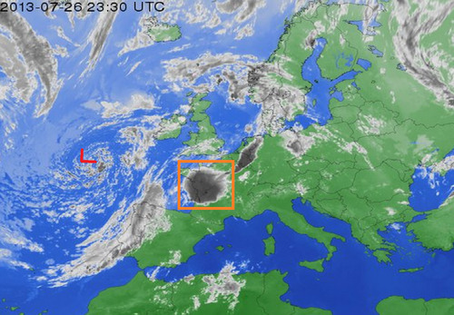
MCS and upper level low

Upper level low spinning off the coast of France and MCS in orange box that could hinder storm activity tomorrow. Infrared satellite image taken Friday evening. (Infrared satellite image source: Weather Online)

The expected severe weather follows a significant weather outbreak that occurred in France on Tuesday afternoon. Strong storms passed through the Burgundy region dropping large hail (between ping-pong and golf ball size) and causing significant damage to vineyards. In this region, crop losses are as much as 75% in the hardest hit areas. Flooding was also an issue, where some main roads such as the one between Pommard and Volnay were flooded out and impassable.

In 2008 an EF-4 tornado touched down around Hautmont, France and caused 4 fatalities and 18 injuries. Severe weather is not that common of an occurrence in France, with only a couple outbreaks per year.

Sunny Weekend Ahead

Sunny weather will dominate the Red River Valley as a ridge of high pressure moves into Manitoba. Temperatures will be below-normal through the next 3 days as we remain entrenched in a cooler air mass originating from the north while the jet stream remains locked up in the United States.

Friday

20°C / 7°C
Mainly sunny.
Saturday

22°C / 11°C
Mainly sunny.
Sunday

24°C / 13°C
Mainly sunny.

Temperatures will slowly climb back towards the mid-20’s by the end of the weekend, while overnight lows will start at an extremely unseasonably cool 7 or 8°C and warm to around 13°C by Sunday night. Skies will be mainly sunny the next several days with no precipitation in sight.

Showery Weather Ahead

A persistant Arctic vortex over the Eastern Arctic will continue reinforcing a westerly to northwesterly flow over the Prairies which has been bringing cooler summer weather to Southern Manitoba. Multiple disturbances are forecast to track down in the northwesterly flow which will produce a showery second half to the week.

Wednesday

22°C / 13°C
Increasing cloudiness then showers with a risk of a thunderstorm in the afternoon.
Thursday

21°C / 11°C
Cloudy with scattered showers. Windy.
Friday

22°C / 10°C
Mainly sunny.

We’ll see a fairly cloudy day today as temperatures climb to only around 22°C. A trough of low pressure will work it’s way into and through the Red River Valley bringing scattered showers with the risk of a thunderstorm through much of the day and the early evening. No severe weather is expected. Skies should clear overnight as we drop to a low of around 13°C.

On Thursday a second – more potent – system will begin working it’s way through the province. Clouds will roll in early on Thursday as an upper disturbance tracks an area of rain through the Interlake. Here in the Red River Valley we’ll likely see another round of scattered showers starting midday with the winds picking up out of the north to around 30km/h with gusts to 50 or 60km/h. Thunderstorms aren’t expected and we’ll see a high near 21°C. Things will clear out overnight as we head to a low of about 11°C.

Friday will bring more stable weather with mainly sunny skies and a high of 22°C. Winds will continue to be breezy through the morning but should begin to let up in the afternoon. Things look very pleasant through the weekend with mainly sunny skies and highs in the mid–20’s with overnight lows in the 12–13°C range.

Mixed, Mild Weather Ahead

A northwesterly flow building over the province will bring mild temperatures and bouts of unsettled weather with little in the way of severe storm threats, making for a fairly pleasant week overall.

Monday

21°C / 12°C
Mostly cloudy; clearing late in the day.
Tuesday

24°C / 13°C
Mainly sunny. Slight chance of showers or thunderstorms in the evening.
Wednesday

24°C / 12°C
Cloudy periods. Chance of showers in the evening.

Today will be marked by relatively cloudy skies with a breezy northwesterly wind as the low pressure system that brought severe thunderstorms to Southern Manitoba yesterday slowly moves out of the province. This has ushered in cooler air once again which will keep our temperatures fairly cool for the next few days – we’re expecting daytime highs to only climb into the low-to-mid 20’s and overnight lows to sit near the 12–13°C mark.

Tuesday will be a pleasant day with mainly sunny skies and a high near 24°C and while there’s a chance of a shower or thunderstorm on Tuesday evening, it really is an outside chance and much more likely to happen over SW Manitoba than over the Red River Valley.

500mb upper trough approaching Manitoba from the Northern Prairies on Wednesday evening (from the GFS).

500mb upper trough approaching Manitoba from the Northern Prairies on Wednesday evening (from the GFS).

On Wednesday we’ll see a chance of showers later in the day under a mixed sky as a long-wave trough rotates towards Southern Manitoba from the Northern Prairies. At this point it doesn’t look too energetic and there’s little in the way of thunderstorms expected. We’ll se a high near 22°C and a low once agin in the 12–13°C range.