Elsewhere in Weather News: July 20th, 2013

Severe Weather Outbreak in Southern Ontario; Numerous Warnings Issued Friday

On Friday, severe weather rolled across much of southern Ontario, southern Quebec and nearby states such as Michigan and New York. Severe weather was imminent in the region as a strong squall line of storms formed with some bowing segments in the morning and continued into a great thunderstorm environment as the afternoon wore on. CAPE values were quite high, shear sufficient and for any storms that remained discrete, a decent tornado potential was there before getting absorbed into the squall line. This prompted a plethora of warnings to be issued, including numerous tornado warnings throughout the day.

Wind damage was the biggest concern on Friday though, numerous reports of wind gusts exceeding 100km/h and even one report as high as 119km/h in Waterloo Ont., were reported. In turn, significant damage was reported across southern Ontario; mature trees knocked down, trees falling on homes and winds flattening crops. As of Friday night 550,000 people were still without power in Quebec and Ontario due to winds knocking down power lines and trees falling on lines. Storm survey teams are expected to head out to various spots across southern Ontario tomorrow to determine if damage was caused by straight-line winds or a tornado touching down. Two unconfirmed funnel clouds had been reported around the towns of Bradford and Barrie, Ontario. Unfortunately one person has died and ten more have been injured because of falling tree limbs; this is a reminder to people that even though a tornado might not be imminent, it’s better to take cover as a storm approaches.

Downed tree

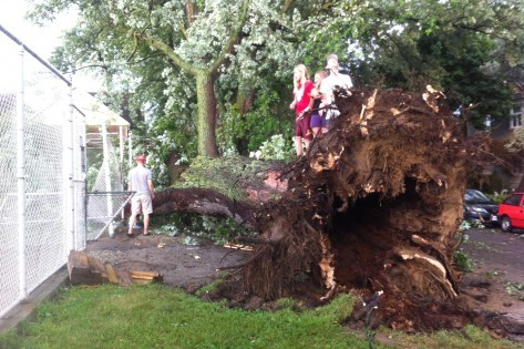
Large trees downed in Toronto by strong winds produced in Friday’s storms. (Source: City News)

The cold front behind this system will put end to Ontario’s heatwave. Many cities in southern Ontario, including Toronto, had reached “official” heatwave status by reaching 32°C three days in a row. This combined with high humidity values made for excessive heat, therefore it’s likely that most residents will welcome the cooler and drier air on Sunday.

Nice Days Ahead

After a very active week across Southern Manitoba, a cold front passed through yesterday that is ushering in a ridge of high pressure that will set us up for a pleasant weekend.

Friday

24°C / 10°C
Mainly sunny.
Saturday

20°C / 10°C
Mainly sunny.
Sunday

24°C / 10°C
Sunny.

A second cold front will be passing through southern Manitoba today however not nearly as much thunderstorm activity is expected with it as the hot, humid air that brought yesterday’s storms has been washed out of the province. A few non-severe thunderstorms are likely over the SW corner of the province and there’s a very slight chance of a thundershower over the Red River Valley, although if that were to happen it would likely be confined to the southern portions closer to the International Border.

A cool air mass will be pushing it with the ridge of high pressure which will allow our overnight lows to drop to around 10°C overnight, which is quite cool for the middle of July. Daytime highs will climb to the mid-20’s today, only to around 20°C on Saturday, then back to the mid-20’s on Sunday.

The start of next week is a little uncertain with some models hinting at another batch of severe thunderstorms on Monday night. We’ll keep you posted!

Rainy — And Potentially Stormy — Thursday Ahead

Sunny skies will turn rather unsettled on Thursday as multiple disturbances move across Southern Manitoba.

Wednesday

Wednesday

28°C
Mainly sunny. Chance of showers near the U.S. border.
Wednesday Night

15°C
Increasing cloud. Showers beginning overnight with the risk of a thunderstorm.

We’ll see mainly sunny skies today as we spend a short amount of time in the stable air behind the cold front that passed through yesterday. That front will be sitting south of the border in North Dakota, however a very strong upper-level jet will be in place through Northern North Dakota near the Canadian border. There will be a slight chance of showers near the border thanks to the extra lift supplied by this feature.

We’ll see increasing cloudiness tonight as the upper-level jet starts pushing back northwards and the aforementioned cold front becomes a warm front and start pushing northwards again. Showers – with the risk of a thunderstorm – will develop over SW Manitoba overnight and advect eastwards into the Red River Valley before morning. No severe weather is expected.

Thursday

Thursday
24°C
Showers ending midday then cloudy with a few sunny breaks and a continued chance of showers.
Thursday Night

15°C
Showers with the risk of a thunderstorm overnight.

Thursday morning will start off rainy with the risk of a thunderstorm. Around 10–20mm of rain is possible however any higher amounts will likely be localized to any heavier patches of rain that develop. Things should taper off by midday leaving us with cloudy skies and perhaps a sunny break or two, but a chance of showers will continue through the afternoon.

Thursday night will start off cloudy then rain will push in by the late evening period as another cold front sweeps southwards from the central Prairies. Unfortunately, this area of rain will likely start off as thunderstorms over SW Manitoba.

NAM sounding valid on Thursday evening near Brandon, Manitoba.

NAM sounding valid on Thursday evening near Brandon, Manitoba.

Quickly looking at some of the convective elements in place:

  • MLCAPE values forecast to be in excess of 2000J/kg
  • 60kt 500mb jet will begin work it’s way into the region with the left exit of the jet poking into the Melita & Virden regions early in the evening.
  • A frontal boundary will be very close to the area providing convergence that can act as a trigger for storm initiation.
  • Falling heights through the upper atmosphere should help prime things for both initiation convection and to sustain anything that does manage to get going.

Low-level shear will not be favourable for the development of tornadoes, but the strong straight-line shear combined with ample moisture and relative low freezing levels will make large hail and torrential downpours a serious concern. Given the shear profile and the strength of the winds aloft, there may be a slight chance that these storms will develop strong straight-line winds. The main threat for severe weather will be over southwest and western Manitoba; at this point it looks like points from Virden to Minnedosa east to the lake then down along the shore-line to Portage face the biggest threat for severe weather, although not much would have to change to include Melita & Pilot Mound regions in there too. We’ll take a look at things a little later today and update this post with a severe thunderstorm outlook graphic if it seems applicable.

The thunderstorms will grow into an area of rain as they travel eastwards towards the Red River Valley. Here in Winnipeg we’ll still see the threat of a thunderstorm overnight, but it should mainly be rain – potentially heavy at times – amounting to about 5–10mm. If we see a thunderstorm than naturally the accumulations could be significantly more than that. The storms and rain should move out of the RRV into Northwestern Ontario overnight.

Friday

Friday

24°C / 15°C
Mainly sunny.

Mainly sunny skies will dominate on Friday as we move into a cooler, stable air mass in behind Thursday’s system. We’ll see the cooler weather persist for another day or so before hot weather begins working it’s way back into the area with temperatures looking to climb back towards 30°C on Sunday. The weekend looks gorgeous so get out there and enjoy it!
Saskatchewan Severe Storm Outbreak; Quiet in the Red River Valley

We’ll move into a slightly quieter pattern after a low pressure disturbance moves through central Manitoba. This system is currently moving through western Saskatchewan and will produce a dangerous outbreak of severe thunderstorms along the Highway 11 corridor between Saskatoon and Regina today with torrential rain, hail possibly bigger than baseballs and a very real threat for an isolated tornado or two. The severe weather threat will be mostly confined to Saskatchewan today unlike Saturday when the substantial severe storm threat was expected to push into SW Manitoba.

Today & Tonight

Monday

30°C
Clearing then mainly sunny.
Monday Night

20°C
Cloudy periods with a chance of showers.

We’ll see a beautiful day toaday in the Red River Valley with sunny skies dominating after a few isolated showers move out of the area this morning. We’ll see temperatures climb to around 30°C this afternoon before some clouds move in in the evening ahead of the storms moving out of Saskatchewan. There will be a slight chance of showers tonight through the Red River Valley along the tail end of a thunderstorm complex that will be moving through the Interlake. As the low pushes across central Manitoba, the Red River Valley will move into the warm sector of this system, bringing much warmer, more humid air into the region. Thanks to this, we’ll see overnight lows quite a bit warmer than the past couple nights. We’ll eventually drop to around 20°C with noticable humidity.

Severe thunderstorms will move into western Manitoba this evening along a dryline pushing eastwards out of Saskatchewan. Storms are expected to stay well north of the Trans-Canada Highway, moving more through the Dauphin & Minnedosa areas then pushing eastwards into the Interlake overnight as an MCS capable of producing large hail and strong damaging winds. The storms will have trouble moving southwards thanks to a layer of dry air in place over the Red River Valley that will likely either kill or substantially weaken any weather that tries to push our way.

Tuesday & Wednesday

Tuesday

27°C / 15°C
Clearing then mainly sunny.
Wednesday

27°C / 15°C
Sunny with cloudy periods.

We’ll see more stable weather for Tuesday & Wednesday as a surface ridge begins working it’s way into the province. A fairly light northwesterly wind will kick in on Tuesday morning which will slowly push out much of the humidity in place over us making this feel quite a bit more comfortable outside. Wednesday will bring more sun than cloud with daytime highs pretty much the same as Tuesday. There will be a slight chance of light showers near the International Border through the period but no significant accumulations are expected.