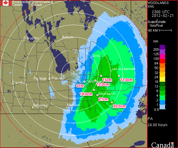
After a wild week of weather that featured heavy snowfall across many parts of Southern Manitoba conditions will begin to calm down. However, the same can’t be said for areas just to our south.
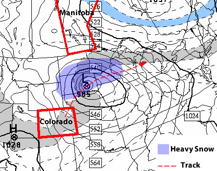
A major winter storm will impact portions of the North-Central United States just south of Manitoba. Areas such as Fargo, North Dakota, Minneapolis, Minnesota, and Aberdeen, South Dakota will be impacted by a Colorado Low system on Tuesday and Wednesday of this week. The hardest hit areas in South Dakota and Central Minnesota may see upwards of 30cm (1 foot) of snow. Wind speeds will also be high during this storm and as such the National Weather Service has issued blizzard watches for portions of the Northern U.S. Plains. Anyone who has travel plans to regions just south of the border may want to reconsider as this will be a significant and potentially life-threatening winter storm.
On our side of the border the weather will be considerably different this week. Temperatures for the first half of the week will be very reasonable. Highs on Monday will be in the -10 to -15C range in most of Southern Manitoba, which is unseasonably cold. Fortunately wind speeds will be light on Monday, making conditions fairly comfortable. By Tuesday and Wednesday temperatures will have increased with highs in most of Southern Manitoba reaching the minus single digits. Temperatures for the remainder of the week will remain mild as an approaching low pressure system develops a southerly flow over Southern Manitoba. The approaching low pressure system will probably reach Southern Manitoba on Friday, potentially bringing a bit of light snow along with it.
With meteorological winter nearly over many people are wondering what March has in store. Unfortunately, there is no clear signal as to how March will evolve at this time. Most models show generally seasonable conditions in Southern Manitoba for the first part of March with no signs of any major warm-ups or cool-downs. Nevertheless, with spring set to begin in just over 3 weeks you can certainly count on the fact that winter’s worst cold is behind us.
Meteorological winter is defined as December, January, and February. Solar (calendar) winter lags behind by about 3 weeks (December 21 – March 21). Meteorological seasons more accurately describe the type of weather that takes place in Southern Manitoba
Elsewhere in Weather News
Flash Flooding in Queensland, Australia
The southeast region of Queensland, Australia experienced flooding this week after more than 330mm of rain fell in some areas. Although heavy rainfalls are not that uncommon in the region, southeast Queensland was deluged with heavy rain the past couple weeks and the river system levels are quite high.
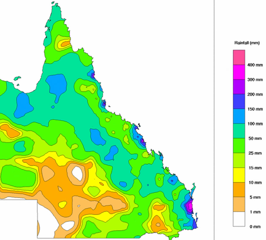
From Friday, February 24th to Saturday the 25th, a surface trough combined with an upper-level low intensifying over Queensland and slowly moving westward, caused the Bureau of Meteorology (BoM) to issue multiple warnings. (In the southern hemisphere low pressure systems spin clockwise and move westward as opposed to the northern hemisphere where lows spins counter-clockwise and generally move eastward.) The BoM had issued flash flood warnings, advising that some of the downpours could easily reach 150-200mm within a day. Severe weather bulletins had also been issued for storms associated with this system however the main threat was flash flooding.
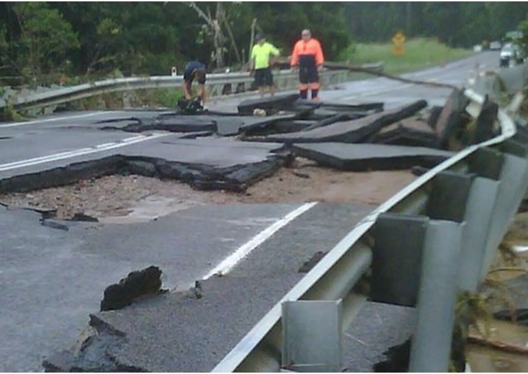
The rainfall caused extensive damage to the road networks in the region, causing authorities to close more than 40 roads and urge residents to stay off roads and only travel for urgent reasons. More than 100 water rescues were made due to rapidly rising water levels and fast flowing streams turning into raging rivers in a matter of minutes. The town of Cooroy which had been impacted by very strong winds earlier in the week had now been cut off by rising waters as the roads heading in and out of town were flooded out. Since then, the water has receded and the town can now travel freely.
The weather should clear up though, as the forecast calls for minimal rain for the start of the work week, with only sporadic showers occurring every second day.
Elsewhere in Weather News has been provided by Matt