Winter will take a vacation this week, as temperatures soar well above seasonal values.
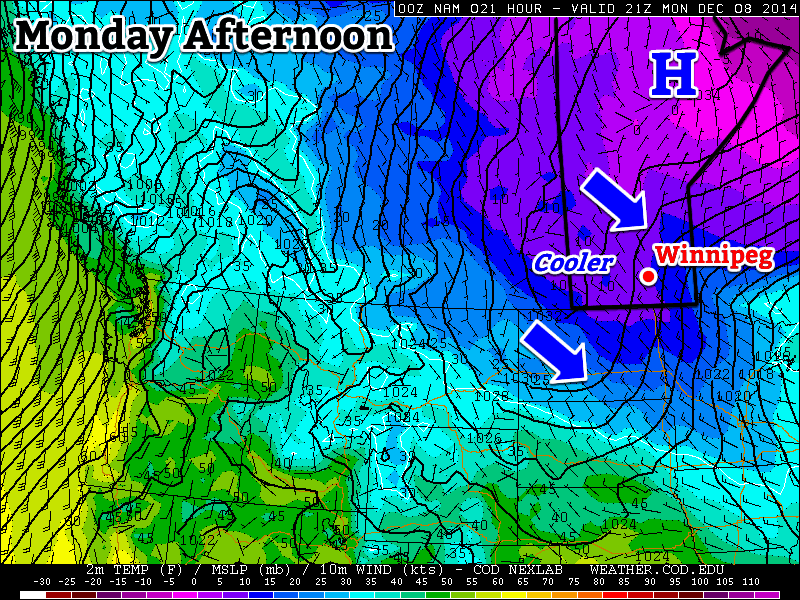
Cooler temperatures are expected in southern Manitoba on Monday
Monday
Monday
-10°C / -20°C
Mainly cloudy with chance of flurries
Today will be our last taste of arctic air for awhile! High temperatures today will be around or just below -10C with a breezy north-west wind. There may be some light flurries during the day, particularly in the morning, but they shouldn’t amount to much, if anything.
Tuesday
Tuesday
-7°C / -8°C
Mainly Sunny
Tuesday will be a bit warmer than Monday, as a strong southerly flow brings warm air into southern Manitoba. High temperatures will be in the minus single digits, which is slightly above-normal for this time of year. The only downside is that it will be very windy, with south winds of 40km/h gusting to 60km/h. Temperatures will not decrease much on Tuesday night as that strong wind keeps conditions mild.
Wednesday
Wednesday
-2°C / -2°C
Mainly Sunny
High temperatures on Wednesday will approach or exceed the freezing mark in most of southern Manitoba. South-western sections of the province should reach the freezing mark, while areas in the Red River Valley and south-eastern Manitoba remain just below freezing. Winds will remain gusty and from the south.
Long Range
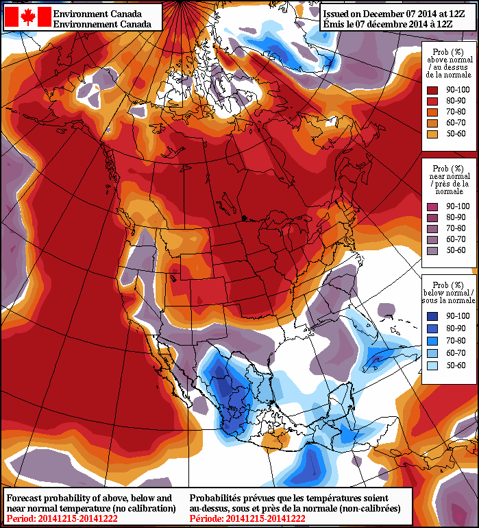
The NAEFS model suggests that above-normal weather will last through mid-December
The long range forecast is looking very good. Models are in strong agreement that our weather will remain above-normal for the foreseeable future. In fact, later this week temperatures will likely be well-above normal, with multiple days potentially being above freezing. There is no sign of any major cool-downs in the forecast – enjoy it while it lasts!
A breakdown in the upper-level ridge over Western North America that has locked Manitoba into an unseasonably cold regime for the past 10 days will result in a significant shift in the weather for the coming weekend as warmer air finally makes its way inland from the Pacific coast. The weekend is set to end with a bang as a low pressure system taps into the warmer air and brings the first major widespread snowfall event to the Prairies.
Friday
-3°C / -5°C
Partly cloudy with a slight chance of light late-day flurries
Saturday
-1°C / -4°C
Mostly cloudy
Sunday
0°C / -13°C
Mainly cloudy; snow possible
Today will be one of those slightly unpleasant transition days into a warmer air mass being brought into the region by a low pressure system tracking across the Central Prairies. Southerly winds to 30-40km/h with gusts up to around 50km/h will make things feel a bit chilly, even though we see a warmer-than-anything-recently high near -3°C or so. If the winds manage to shift more southwesterly, then we could see several degrees added onto that high, jumping up to 0 or +1°C, however the deep layer of cold air and outflow from the ridge to our southeast will likely keep things on the cooler side.
There will be a slight chance of flurries late this afternoon into early this evening as the warm front passes by. Otherwise tonight will see mostly cloudy skies as temperatures drop to around -5°C.
Saturday looks like a fairly quiet day. Mostly cloudy skies, light winds and a high near -1°C will make for a fairly pleasant day. Temperatures will drop to around -4°C under cloudy skies and increasing east-southeasterly winds.
Sunday Brings Major Snowfall to Portions of Southern Manitoba
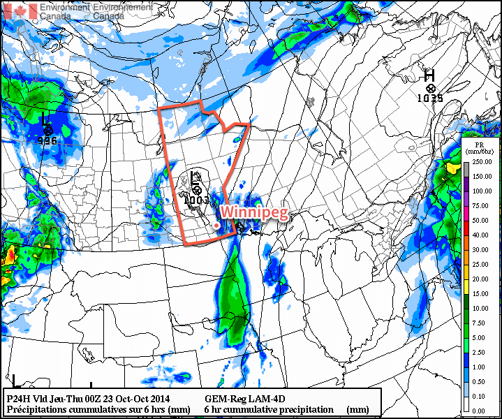
A low pressure system tracking along the International border is set to bring a substantial snowfall to portions of the Parkland & Interlake regions as a weak inverted trough persists through the region for much of the day. Snow is expected to push into Western Manitoba late Saturday and spread eastwards into the Interlake and onwards across the lakes into eastern Manitoba by Sunday morning.
A Weather Moment snowfall forecast for November 22-23, 2014. Up to 20cm of snow is possible through portions of Southern Manitoba.
Snowfall will be fairly heavy at times, and in general amounts will likely fall into the 10-15cm amount for a large swath from Dauphin to The Pas extending eastwards. For portions of the Swan River region eastwards through the northern Interlake and into Berens River, slightly higher amounts will likely be seen with up to 20cm possible.
Further south in the Red River Valley, some light snow is likely, however there’s some considerable uncertainty in how the evolution of this system will take place which is resulting in quite a spread of results. The general consensus at the moment is that little snow will be seen with amounts generally less than 2cm on Sunday, however some guidance suggests that strong low-level instability and strong lift behind the passage of the cold front in the afternoon could result in fairly intense snow over the region.
As we get closer to the event, we’ll be able to refine this forecast a little more, particularly for the Red River Valley.
Other than the snow, Sunday will be fairly mild with a high near 0°C in Winnipeg while winds starting off relatively light out of the east-southeast backing to northwesterly at a gusty 30-40km/h with some blowing snow in rural areas by Sunday evening. Much cooler air will push in through Sunday night which should allow the overnight low to drop into the minus teens.
Next week looks to start off a little unsettled with some flurries hanging on in Southern Manitoba while another shot of Arctic air begins working into the region.
A cold front passing through Southern Manitoba later today will usher in cooler air, but temperatures will only dip slightly and remain above-normal through the weekend.
Friday
16°C / 5°C
Mixed skies; windy in the afternoon
Saturday
11°C / 2°C
Mainly sunny
Sunday
12°C / 5°C
Mainly cloudy wiht a chance of showers
Friday Brings Blustery Winds
Today will be a warm day across the Red River Valley with daytime highs in the 15–16°C range – around 8°C above the normal daytime high of 7°C – under mixed skies trending towards cloudier this afternoon. A tightening pressure gradient coupled with an advancing cold front will bring fairly gusty winds into the province this afternoon, with southerly winds shifting to westerly-to-northwesterly and increasing in speed to 35–45km/h with gusts as high as 60–70km/h. No precipitation is expected with the passage of the cold front.
The 850mb temperatures from the NAM model clearly show the cold front passing through Southern Manitoba this afternoon.
Temperatures will drop to around 5°C tonight under clearing skies.
Mixed Weekend Ahead
Saturday is shaping up to be a very nice day with a few clouds, diminishing winds and a high near 11°C. Saturday night should bring clear skies and a low near 2°C.
Sunday will see a warm front lift into the Red River Valley, resulting in a mainly cloudy day with a chance of showers as the front moves through; it’s looking like the rain potential is in the afternoon at this point. Expect a high in the low teens alongside some breezy southeasterly or easterly winds moving towards an overnight low around 5°C.
Above-normal temperatures[1] will continue through the remainder of the week as a southwesterly flow aloft continues to pump relatively mild Pacific air over the Prairies.
Wednesday
17°C / 8°C
Increasing cloud with a chance of showers
Thursday
15°C / 7°C
Mainly cloudy
Friday
16°C / 5°C
Some morning cloud, then sunny
Unsettled Wednesday
Today will be the most unsettled day of the week thanks to a (very) weak cold front pushing eastwards across the Red River Valley today. A fairly sunny start to the day will become more mixed by mid-day with a slight chance of shower activity in Winnipeg mid-day into the early afternoon. It seems most likely that the activity will remain to the east of Winnipeg, with showers or even thunderstorms almost a certainty in the Whiteshell southwards to the US border.
Precipitation forecast for this afternoon from the Canadian RDPS model.
The American NAM weather model has been an outlier for several runs in a row, producing a fairly potent band of showers and thunderstorms over the western Red River Valley and pushing eastwards through the day. Given the weak surface forcing, mediocre moisture and the rate and evolution of the upper-level destabilization, it seems that the NAM is probably over-doing things and not a likely forecast. It’s worth mentioning here as an outside possibility, though, given its consistency in producing that outcome.
Other than the showers, strong southerly winds at 40 gusting 60km/h will taper off this afternoon behind the weak cold front as they shift to westerly at around 20km/h. The temperature will climb to around 17°C today.
Skies will clear out this evening as the temperature drops near 8°C for the overnight low.
Pleasant End to the Week
Thursday and Friday will both be pleasant fall days – especially for late October. Dry weather will be the name of the game for both days with highs in the mid-teens and fairly light winds. Some cloud will push across the Red River Valley on Thursday night but otherwise things will be mainly sunny/clear. The temperature will dip to around 6 or 7°C on Thursday night and a bit cooler – near 5°C – on Friday night.
Heading into the weekend, the weather continues to look pleasant with highs in the teens, no real threat of rain and plenty of sunshine. Enjoy!
Normal daytime highs for this time of year sit around the 8°C mark. ↩