Elsewhere in Weather News: March 8th, 2014

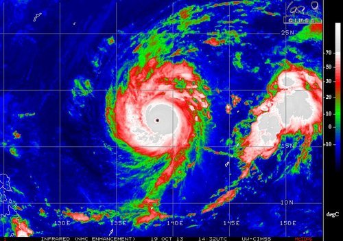
Cyclone Takes Aim at Northern Queensland

On Thursday, March 7th an area of convection appeared off the northern coast of Australia in the Arafura Sea, associated with a weak tropical disturbance. Since then the convection has remained nearly stationary due to steering winds being fairly weak but not much organization has occurred. However, the disturbed area is expected to organize quickly today into tomorrow as it drifts slightly to the southeast where shear values are low and sea surface temperatures are very warm; 30-31°C. By Sunday evening it is expected that Gillian become a category two cyclone, just off the northern coast of Queensland.

Infrared satellite image of Gillian looking rather disorganized, but with some deep convection on Friday evening. (Source: CIMSS)

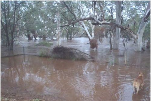
The Australian Bureau of Meteorology (BoM) warns that winds could approach 150km/h in areas closest to where it makes landfall. Shoreline areas are most at risk along the peninsula due to the storm surge and large waves. Flooding/flash flooding is also expected as areas along the coast have received around 850mm in February; over double their average rainfall for that month. Another 250-400mm could fall in the region due to Gillian. It is expected that Gillian linger through the beginning of next week and die out as it continues south over land.

Queensland's rainfall for the past 30 days, note the area of 800+mm, this is where Gillian is headed. (Source:BoM)
Queensland’s rainfall for the past 30 days, note the area of 800+mm, this is where Gillian is headed. (Source:BoM)

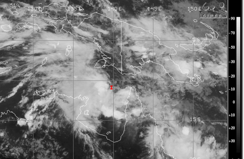
Interestingly enough a second, weaker, cyclone is spinning off the east coast of Queensland and is expected to make landfall at about the same time that Gillian does as a strong category one. Both cyclones are to watch Sunday into the beginning of next week as they pose a threat to the northern and eastern areas of Queensland. The Australian cyclone season begins November 1st and ends April 30th and on average they see about ten cyclones per year.

Elsewhere in Weather News: March 1st, 2014

Australian Town Sees Flooding Rains

The town of Dajarra, a small Australian town in the northwestern part of Queensland, has faced flooding problems that started mid-week and worsened Thursday. The flooding was associated with a surface trough of low pressure that stayed nearly stationary for over 24 hours and sparked slow moving convection. General reports of 60-80mm in the region were reported but some localized amounts reached as high as 150mm. In addition, the region has been drought-stricken in the past few months which makes it tougher for water to infiltrate soils and easier to runoff.

Wills River overflows its banks in Dajarra. (Source: ABC)

The result of all this rain was that creeks overflowed their banks and quickly turned into raging rivers. Most residents were evacuated as homes were threatened or were inundated by the floodwaters. Some workers from the railway were also stranded but have since been saved from the waters. The town is still cut off due to floodwaters as of Friday evening.

Dajarra’s average rainfall for the whole month of February is 100mm but they have received over 125% of this in the past week. It appears as though the surface trough will linger until the end of this weekend and continue to bring unsettled weather. This event comes two weeks after the flooding that occurred in Adelaide, South Australia, which wreaked havoc on the city. In one day 73mm of rain was dumped on Adelaide making it the most rain the city had received on a single day in February since 1969.

Elsewhere in Weather News: January 11th, 2014

Cyclone Ian Hits Tonga

This year’s first strong cyclone has spun up in the Southwest Pacific of the Southern Hemisphere. The cyclone – cyclone Ian, formed to the southwest of the Samoan islands and quickly strengthened under prime conditions for intensification. Yesterday the strongest part of Ian clipped the islands of Tonga, as a category four bearing winds around 225km/h and an estimated central pressure near 950mb. All kinds of hazards are associated with a cyclone of this strength: landslides, storm surges and flooding. These risks are enhanced because this cyclone is slow moving. Communications had been cut off from the northern islands on Friday night, where a state of emergency had been issued, therefore the scale of damage to the island remains unknown there. The island of Hunga had reported damage to homes that had their roofs blown off. Tonga’s capital, which is about 100km further south than the northern islands, did not take a direct hit and only minor damage/flooding has been reported there.


A small, but compact cyclone Ian can be seen on IR satellite passing over Tonga on Friday evening. (Source: CIMSS)

The cyclone is expected to continue moving southeast into the south Pacific where it will die off due to cold sea surface temperatures; unfavorable for development.

Australia Baking Under Intense Heat

In other news, Australia is experiencing an intense heat wave which broke numerous daily records as well as a few all-time records such as the new all-time high of 48°C reached at Narrabri on January 3rd. The country has been plagued with heat waves the past few years, including last year which was Australia’s warmest year on record since records started.

Elsewhere in Weather News: October 19th, 2013

Australia Torched by Wildfires

This past week wildfires have been sweeping across New South Wales (NSW), a state located in the south-eastern part of Australia. A few thousand residents have been evacuated due to the fires, about 200 properties have been destroyed and one resident has died from the fires. West/northwest winds have been pushing plumes of smoke towards Sydney and dropping ash at the same time causing low visibilities at times and trouble for asthmatics. Currently, it’s not clear what started the fires. Some 60 fires were burning as of Thursday and about a third of them were not contained.

NSW fires

A few of the larger fires burning in NSW. Satellite image shows the plume of smoke over Sydney. (Source: NASA)

Unseasonably warm and dry weather is a factor as firefighters continue to battle the blaze in addition to dealing with gusty winds. A large high pressure sitting just off Australia’s east coast is to be blamed for bringing in the gusty northwest winds fuelling the fires. The next shot NSW will have at rain looks to be Tuesday as an area of low pressure passes to the south; the bulk of the rain will stay south but showers are still possible.

Yet Another Super Typhoon Forms

Francisco

Super typhoon Francisco on Saturday morning. Note the well defined eye. (Source:CIMSS)

Super typhoon Francisco formed earlier this week and has already reached category five status as it churned over the very warm waters of the Northwest Pacific. This morning, a very well defined eye could be seen as Francisco started to move northwest, taking aim at Japan. It is expected to make landfall somewhere on the south-eastern coast of Japan, though there is some uncertainty as to where exactly since it still has four to five days to travel over ocean waters. Regardless of where it makes landfall it will pose a flooding threat to all of Japan’s four main islands. Thankfully, by the time Francisco reaches Japan it will have weakened as lower sea surface temperatures will make it tough for Francisco to sustain itself. The typhoon will likely be of category one or two as it makes landfall next week.