Elsewhere in Weather News: June 29th, 2013

Australia Faces Flooding Problems

This spring has been disastrous flood-wise across the globe; hundreds of billions of dollars of damage to crops and infrastructure from a few significant floods such as the Chinese floods, European floods and closer to home; Albertan floods as talked about in last week’s EIWN. Extreme flooding continues this week, most notably in Australia’s New South Wales state.

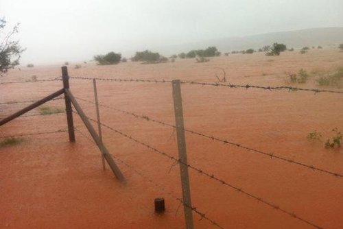
In the past few days coastal areas of New South Wales have received copious amounts of rain. Consequently, flood evacuations have had to be issued for a few towns just outside of Sydney (Richmond Lowlands, Pitt Town, Gronos Point). The Warragamba Dam, located to the west of Sydney, was overwhelmed by the 150mm of rain that fell in a 24 hour period starting Wednesday, prompting for the flood evacuations. Many roads and a few key bridges in the area had to be shut down because of the overland flooding. In addition, a few search and rescue missions have had to be executed because of people trapped in floodwaters. Thankfully no casualties have been reported as of yet related to this flooding.

Rainfall June 29

Rainfall map for the past 7 days as of Friday. Circled in red the area experiencing flooding, localized areas of 200mm+. (Source: Australia’s BoM)

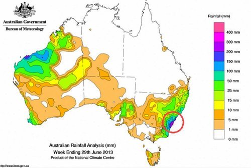
It appears as though a lingering trough of low pressure is to blame for all the rain on the eastern coast of Australia on Wednesday. Sydney and surrounding areas get on average about 130mm of rain for the whole month of June. Compared to this past week where in some areas 200mm (or more) have already fallen, these areas have already doubled their average rainfall for June, significant flooding is not surprising. This weekend appears to bring more rain to the coast of New South Wales, though not another significant rainfall event.

Elsewhere in Weather News: March 23rd, 2013

Damaging Tornadoes Touch Down Across the World

Tornadic activity was experienced across the globe this past week, affecting countries from Bangladesh to Australia and even China.

Australian tornado

Capture of the Doppler Radar velocity at the time of the tornado (area of dark blue vs. red). (Source: BoM/ @vicstormchasers)

In Australia on March 21st , at least two powerful tornadoes touched down on the border of Victoria and New South Wales, ripping through more than a half-dozen towns lying along the Murray River. The strongest twister, with an estimated F2 rating on the Fujita scale, caused major damage to the towns it swept through – tearing roofs off their structures, throwing cars around and snapping power lines. In total, 20 people were injured and two had to be airlifted to hospital. Thankfully no deaths were associated with this tornado outbreak. A deep low pressure system responsible for spawning these tornadoes lay just off Tasmanian coast with a cold front stretching up into Australia.

Video of the Australian tornado dangerously close up. Power flashes and debris can clearly be seen flying through the air. (Source: Daniel Clarke)

The tornado that touched down in Bangladesh on Friday, March 22nd also caused a fair amount of damage to a few rural eastern Bangladesh towns. The twister was on the ground for about 15 minutes but it is not yet known what the strength of the tornado was estimated to be. At least 100 injuries and 20 deaths were reported as a result of this tornado.

The people of Bangladesh are more susceptible to injury and death from tornadoes since finding a safe haven from them is not as easy as heading down to a basement to take cover. Most houses in the area are built out of mud and don’t have a sturdy structure, making it difficult to escape when residents find themselves in the path of a twister. Tornadoes are common in Bangladesh from March to late April before they transition into the monsoon season.

Guangdong, a southern province of China, was also in the crosshairs of severe weather this week. A supercell produced egg size hail accompanied with a tornado that made its way through the city of Dongguan (pop. 400,000). Significant damage occurred – many buildings collapsed and the storm even overturned a ferry offshore. These Chinese storms were the deadliest storms of the week, accounting for 24 deaths and over 200 injuries.

China egg-size hail

Hail the size of eggs covers the ground in Dongguan, China. (Souce: I.B. Times)

Elsewhere in Weather News: March 9th, 2013

Australian Waters Remain Active

This past week, Australia and its surrounding waters have remained active as yet another cyclone has spun up – this time in the Coral Sea. Cyclone Sandy, currently located about 1,200km north-east of Queensland, Australia, is headed in an easterly direction with sustained category one hurricane winds of 120km/h. The cyclone is too far off coast to adversely affect the state of Queensland at this time.

Sea surface temperatures

Sea surface temperatures with forecast track/intensity and cone of uncertainty (purple) as of Friday night. (Source: CIMSS)

Cyclone Sandy’s route is expected to shift to a south-easterly direction this Saturday but there is much uncertainty as to its destination after the forecasted three-day track. Almost all models agree that Queensland will be spared from this storm, but the island of New Caledonia is still at risk for a direct landfall. This landfall could have a significant impact on New Caledonia as Sandy is expected to continue to strengthen. Before the cyclone weakens, there is a good possibility that it attains a category four level with sustained winds of approximately 180km/h due to sea surface temperatures being very warm (29°C). If the storm does manage to avoid New Caledonia by taking a southerly track, it’s likely that it will die off in the Tasman Sea and not affect populated areas.

Shear

Shear values in yellow, as of Friday night. Low shear environment will contribute to Sandy’s intensification. (Source: CIMSS)

Australia’s cyclone season runs from November 1st to April 30th. Currently they are at the peak of the cyclone season. On average, 11 cyclones affect Australia per year and the tally so far this year (including Sandy) has reached 8 cyclones – a normal count for this time of the year.

Elsewhere in Weather News: March 2nd, 2013

Strong Cyclone Affects Australia, Temperature Records Tallied

This past week a cyclone, Rusty, formed off the coast of north-western Australia and quickly spun into a strong cyclone by Australian standards. The cyclone made landfall as category one by Saffir Simpson Scale standards, (rated category 3 by Australian Bureau of Meterology) and even though it brought hurricane force winds, it affected an area of Australia that is sparsely populated. This meant that not much damage was caused by Rusty and only some overland flooding was reported as well as about a hundred houses without power. As Rusty moved inland, heavy rains and high wind gusts were the main concerns; over 450mm of rain fell and gusts of 150km/h were experienced around and south of the area where Rusty made landfall. Rusty’s quick strengthening off the north-western was aided by unusually warm waters – near 31°C and only about ten knots of shear present at the time.

Rusty Flooding

Flooding in an area just south of where Rusty made landfall. (Source: @Sturap)

This week the Australian Bureau of Meteorology also announced that the warmest summer on record (records since 1910) occurred this past summer. Australia’s average temperature surpassed the normal by 1.1°C and 95% of the country had above average temperatures this summer. Birdsville, Australia which typically has an average high temperature between 35°C and 38°C during summer had 31 consecutive days above 40°C. It has truly been an impressive summer 2012-2013 temperature-wise for Australia!

Average temperature anomalies

Average temperature anomalies for Australia summer 2012-2013. Much of Australia above average. (Souce: BoM)

In other news, another significant blizzard went through the Southern US Plains bringing more short-term drought relief to the area. Some areas in north-western Oklahoma and the Texas Panhandle received over 35cm of snow. Blizzard conditions were in place as strong winds and heavy snow fell along the deformation zone of the low pressure system. Almost all roads in the Texas Panhandle were impassable because of large snow drifts, residents were urged to stay home. Weather in the Southern Plains will be fairly calm this weekend and at the start of next week; no significant precipitation accumulation is expected.