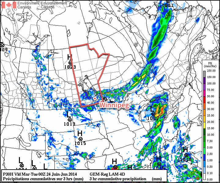
We’ll see cooler weather to start the week alongside some more shower activity as the upper low that has plagued the region for the past week finally makes an exit.
More organized shower activity is expected today throughout much of Southern Manitoba.
Monday
Monday
20°C / 12°C
A mix of sun and cloud with showers.
Today will feature below normal temperatures and a good chance of rain. Shower activity should pop-up relatively quickly during the day as daytime heating destabilizes the atmosphere. High temperatures will be near 20C with a light west wind shifting to northerly in the afternoon.
Tuesday
Tuesday
19°C / 10°C
A mix of sun and cloud with a slight chance of showers.
Tuesday will see temperatures cool a bit further from Monday’s values. High temperatures will be in the upper teens, with a slight chance of showers sticking around. The wind will be breezy and from the north.
Wednesday
Wednesday
22°C / 12°C
A mix of sun and cloud with a slight chance of showers.
Wednesday will see little change from the previous two days. Temperatures will warm slightly from Tuesday, with highs into the low twenties, but a slight chance of showers will remain.
Long Range
We should see temperatures rebound to normal or above-normal values by week’s end. In addition to the warmer weather, models are also indicating that more humid air will return and we may even head into the first multi-day hot and humid event of the summer.
Models also hint at the risk of strong thunderstorms returning by next weekend, but it’s too soon to say for sure.
A powerful low pressure system drenching North Dakota and Minnesota will brush the southeastern portion of the province today. For the rest of us, fairly quiet weather will prevail with slightly below-normal temperatures.
Wednesday
17°C / 8°C
Mainly cloudy. Outside chance of some light showers.
Thursday
18°C / 6°C
Mainly sunny.
Friday
23°C / 13°C
Sunny, then increasing cloud late in the day.
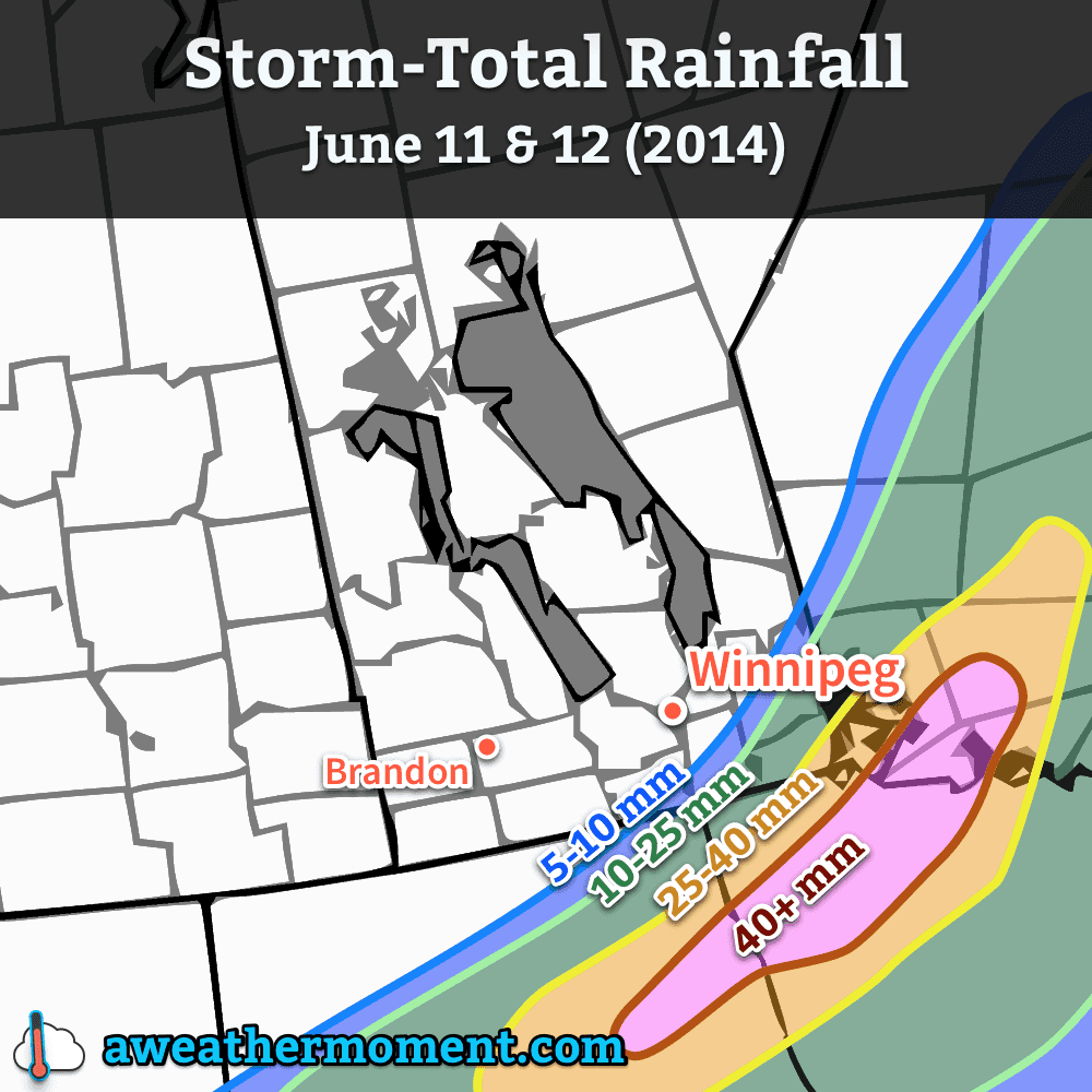
The main weather story today will be the low pressure system working its way through North Dakota and Minnesota. Although this system will spread cloud through the entirety of the Red River Valley, rainfall will be constricted to the southeastern portion of the Red River Valley into SE Manitoba. At this point, it looks like the main area of rain will remain south and east of Steinbach. There’s a slight chance of showers backing into Winnipeg and the SW Red River Valley (Altona, Winkler), but if any precipitation managed to push that far north or west, it would remain very light.
Forecast rainfall amounts for the system clipping southeastern Manitoba through June 11th and 12th.
Otherwise, it will be a mainly cloudy day with perhaps a few sunny breaks through the first half of the day. Winds will be a little breezy out of the north at 20-30km/h. Temperatures will top out around 17°C. Clouds will begin to push off to the east overnight, however the bulk of the RRV won’t see complete clearing until Thursday morning. Overnight lows will be near 8°C.
Cool But Pleasant End to the Week
Thursday and Friday both look to be quite nice, with temperatures some 5°C below normal returning to seasonal values. Thursday will see clearing skies as temperatures climb to 18°C. Winds will be light out of the north as a ridge of high pressure begins working its way eastwards into Manitoba. There may be a slight chance of some shower or thundershower activity over western Manitoba, but here in the Red River Valley things look sunny and dry. The overnight low on Thursday will generally sit around 6°C; this will likely be the coolest night for the next while.
Friday will be another mainly sunny day with warmer weather returning as the ridge of high pressure shunts off to the east and a southerly flow redevelops over the province. Under mainly sunny skies the temperatures will climb to near 23°C. Cloud will move into the Red River Valley late in the afternoon or the evening and the next system pushes into southwestern Manitoba. Temperatures will drop to around 13°C.
Unsettled Weekend
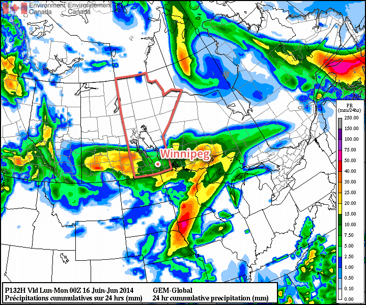
This weekend will be marked by unsettled weather as a major low pressure complex moves into Southern Manitoba and the Northern Plains of the United States. Rain, with the chance of thundershowers, will push into southwestern Manitoba on Saturday morning. There’s uncertainty as to what will happen after that, but at the time it appears that rain will likely slide eastwards along the international border through the day.
GDPS 24hr. precipitation amounts from Saturday evening to Sunday evening. The GDPS is forecasting 5-10mm of rain in the RRV for this period, with higher amounts west, south and east.
Afterwards, the general trend looks to be a shift northwards with the precipitation towards the northern Red River Valley, and then things push out late in the day on Sunday. Daytime highs on the weekend should rest in the low 20’s while overnight lows hover near the 11-12°C mark.
Although temperatures will be a little below normal for foreseeable future, a fairly pleasant few days are on tap for Winnipeg. A ridge of high pressure over the central Prairies will work at clearing out the clouds giving us plenty of sun for Friday and Saturday while winds slowly diminish. A low passing through on Sunday will mark the return of potentially rainy weather.
Friday
19°C / 7°C
Sunny with afternoon clouds. Breezy.
Saturday
18°C / 7°C
Mainly sunny.
Sunday
18°C / 8°C
Cloudy periods with a chance of showers.
Significantly cooler air than seen over the past week is working its way across the Prairies into Southern Manitoba, dropping daytime highs from the the mid-to-high 20s to the high teens. Temperatures will remain roughly 5°C below normal for the next week as a much cooler pattern locks in; daytime highs aren’t expected to reach over 20°C until late into next week.
Today will bring some late morning/afternoon cloud with a breezy west-to-northwesterly wind at around 20-30km/h. Temperatures will reach around 18°C. Expect clearing skies tonight and a low of around 7°C.
Tomorrow will be very similar to today except with a little less cloud and lighter winds. High near 18°C once again and a low near 7°C again.
Showery Sunday?
A weak low pressure system is forecast across Southern Manitoba on Sunday, bringing a renewed chance of showery weather. At this point, it looks like little in the way of particularly active weather will occur; even a rumble of thunder looks out of the question.
Probability matched mean precipitation from the SREF model for Sunday morning.
In general, the system is expected to spread some light shower activity from west to east across Southern Manitoba through the morning hours, persisting into the afternoon. Overall amounts look to be low; in the image above, I’ve used a probability matched mean ensemble[1] which can better capture higher amounts embedded within the mean precipitation field, and it still only shows around 2-4mm for most areas.
There are some hints the system may pick up strength and produce 5-10mm over the woods from Pinawa down to Sprague, but it’s still a little too far out to say much reliably.
Sunday won’t be all showers and cloud, though with a good chance of a few sunny breaks through the day. Highs will be near 18°C once again with an overnight low around 8°C.
Heading into next week it looks as if the cooler temperatures will continue with a couple more chances for precipitation through the first half of the week.
For those who are curious, this takes the ensemble mean value, but matches the rain rate distribution in the ensemble mean field to the complete ensemble. Can help prevent “smearing” of the precipitation field. ↩
Things will seem decidely early-April as extremely cool air settles in over the eastern Prairies bringing another stretch of days with temperatures some 10-15°C below normal. Seasonal weather doesn’t look to return until the end of the week when the cold air finally begins being shunted off to the east.
Wednesday
7°C / -4°C
Mainly cloudy. Clearing in the evening.
Thursday
10°C / -1°C
A few clouds.
Friday
12°C / 3°C
Mainly sunny. Cloudy periods overnight.
We’ll see a mainly cloudy sky today as we remain stuck under cloud wrapping around the backside of the low pressure system that impacted Winnipeg and the Red River Valley over the weekend and the first half of the week. Accompanying the cloud cover will be extremely cool temperatures for mid-May; the daytime high today will only reach 6 or 7°C, 10-15°C below the seasonal high of 19°C. The cloud cover looks to begin clearing out ovenright as we drop down to a low of -4°C, again nearly 10°C below our seasonal low temperature for this time of year. No precipitation is expected today or tonight.
Tomorrow will bring a few clouds as we sit on the fringe of the organized cloud pushing off to our east and then see some afternoon cumulus clouds develop. Temperatures will moderate a little to around 10°C, however that’s still nearly 10°C below normal for this time of year. We’ll drop to a low of around -1°C overnight under clear skies.
Friday will bring plenty of sunshine with just a few clouds through the afternoon hours. We’ll see a high temperature of around 12°C as milder air continues to slowly push eastwards. There will be a few cloudy periods overnight as a weak disturbance moves thorugh and we’ll see an overnight low near 3°C. Precipitation is unlikely with this disturbance.
Returning to Near-Normal on the Weekend
Things will get back into form by the end of the weekend as the cold trough finally collapses and pushes well off to the east, allowing milder air to spill across the Prairies. Saturday looks like it will have a high somewhere in the mid-teens followed by temperatures near 20°C on Sunday. The weekend looks to be a bit of a mixed bag with sunny skies and relatively light winds on Saturday, but more cloud and stronger winds developing on Sunday as a warm front pushes into the region ahead of a low approaching from Wyoming. Areas all across Southern Manitoba may end up wtih the threat of some showers or rain activity by Sunday aftenroon. We’ll have more details on this system in Friday’s blog post.