Summer Heat Arrives in Southern Manitoba

Temperatures in Winnipeg will soar this weekend as a strong upper ridge draws summer heat north into the province.

RDPS 2m Temperature Forecast valid 21Z Sunday May 4, 2025
This weekend will bring the warmest weather so far this year to southern Manitoba.

Winnipeg has had a couple mild days this spring, but none that will compare to the heat that builds into the region this weekend. With a cooler Thursday behind us, yesterday’s northerlies will be replaced with light westerlies as milder Pacific air begins to push east. Today will trend cooler with a high in the low teens as the region transitions out of the colder air that moved into the region. While the day will start with cloud in the region, it should break up and move out for the afternoon.

Temperatures will dip into the 5–10 °C range tonight under clear skies as light winds shift southerly.

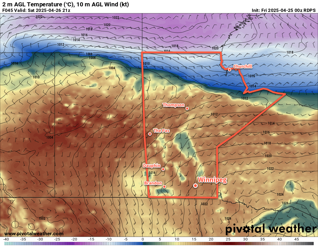
Heading into the weekend, the early-season heat is on with mainly sunny skies through the weekend. Saturday will bring daytime highs into the mid-20s while Sunday will likely be warmer with highs in the mid- to upper-20s . Winds will shift westerly through Saturday but should remain light. On Sunday, the winds will strengthen from the south to as high as 40 gusting 60 km/h. Those winds will ease into the 20 to 30 km/h range on Sunday night. Overnight lows in both nights should sit in the 10 to 15 °C range.

Long Range Outlook

The warm weather will stick around for Monday, then ease to seasonal values for a couple days before more heat builds back into the region. No significant precipitation is in the forecast.

Today’s seasonal daytime high in Winnipeg is 16 °C while the seasonal overnight low is +2 °C.

Pleasant Weekend Weather Arrives

Temperatures in Winnipeg will climb into the upper teens as the weather turns sunny and warm this weekend.

RDPS 2m Temperature Forecast valid 21Z Saturday April 26, 2025
Mild temperatures will spread across the Prairies this weekend.

Beautiful spring weather will move into southern Manitoba this weekend. A combination of a weak upper ridge sliding into the southern Prairies along with a low pressure system crossing the northern Prairies will push warmer temperatures across the Prairies.

Under sunny skies, temperatures in southern Manitoba will climb into the 15 to 20 °C range this afternoon. An area of high pressure sitting right over southern Manitoba will keep winds light, making for a beautiful afternoon outside. Temperatures will dip down close to the freezing mark tonight; winds will shift out of the south as the area of high pressure drifts southeast of the province through the night.

Saturday will bring more sunshine to the region as temperatures climb into the upper teens. Southerly winds will be more prominent, picking up into the 30 to 40 km/h range. Those winds will ease on Saturday night as cloud cover pushes into the region.

The next disturbance to impact the region will be taking shape over the western United States on Sunday. This will keep skies cloudy over the region through the day and bring a small chance of a rain shower or two to the region. Southerly winds will continue through the day at 20 to 30 km/h as temperatures climb into the mid-teens.

The low pressure system south of the border will take shape on Sunday night as it pushes into the Dakotas. North of its track, showers and/or thunderstorms will spread through the northern United States. North of the border in Manitoba, the chance for rain showers will pick up through the night as temperatures dip into the upper single digits.

Long Range Outlook

Much of the rain with this system is expected to track south of the border, while areas further north see a decreasing chance of precipitation. On Monday, a cold front will sweep south through the region, bringing moderate northerly winds and cooler temperatures. In Winnipeg, temperatures will likely hover near 10 °C with cloudy skies giving way to clearing late in the day.

The rest of the week will bring cool to seasonable temperatures with sunshine giving way to more cloud and another chance of showers. Cooler, sunnier conditions are possible to end next week.

Today’s seasonal daytime high in Winnipeg is 14 °C while the seasonal overnight low is +1 °C.

Bitter Cold Eases Across Southern Manitoba

The bitterly cold air that slammed into southern Manitoba earlier this week is on its way out, and after an unpleasant Friday, nicer winter conditions will develop for the weekend.

RDPS 2m Temperature Forecast valid 21Z Saturday December 14, 2024
Breezy southerly winds will eventually bring warmer temperatures to southern Manitoba.

Although warmer weather will begin working its way into the Red River Valley today, it will be a rather miserable day outside. As an Arctic high slowly works its way east, its return flow of cold air will strengthen over the region. Southerly winds will strengthen into the 30 to 40 km/h range as temperatures climb towards a high in the mid-teens, but those winds will keep wind chill values in the -35 to -25 range through the day.

The southerly winds will continue into the night and temperatures will warm slightly overnight as skies cloud over.

Heading through the weekend, a low pressure system tracking across the southern Arctic will spread milder air east through the Prairies. With skies on the cloudier side through both Saturday and Sunday, temperatures will rise into the -10 to -5 °C range on Saturday and closer to the freezing mark on Sunday. It will be a bit of a breezy weekend, though, with southerly winds of 20 to 30 km/h on both days. Overnight lows will climb into the -10 to -5 °C range for the weekend.

Long Range Outlook

More snow is possible overnight Sunday into Monday as a low pressure system develops and moves through the Dakotas. Early indications are that 2 to 5 cm of snow are possible before this system moves out of the region on Tuesday. Colder weather will build in behind it with temperatures dipping back to seasonably cool conditions.

Today’s seasonal daytime high in Winnipeg is -10 °C while the seasonal overnight low is -19 °C.

Sunshine Reappears in Winnipeg…Briefly

The sun will finally make a reappearance in Winnipeg today as colder weather moves into the region.

RDPS 2m Temperature Forecast valid 12Z Saturday November 30, 2024
Winnipeg will see chilly overnight lows near -20 °C in the days ahead, but it will be much colder to the west.

Morning cloud cover will give way to sunshine today as the never-ending blanket of stratus cloud finally moves out of the region. The minor cost to finally kicking some of the gloom that’s set in is that temperatures will drop across the region. In Winnipeg, temperatures will hover just below -10 °C today with norhtwest winds steady around 30 km/h.

The winds will ease to around 20 km/h tonight with temperatures dropping close to -20 °C. A bit of lake-effect cloud and snow is possible off of the Manitoba Lakes, so Winnipeg could find itself with mixed skies through the night and perhaps some scattered flurries. Between the wind and the vicinity cloud, it’s unlikely that temperatures will drop much below -20 °C, if at all.

Much colder temperatures will sit just to the west of the Red River Valley; overnight lows in the -25 to -35 °C range will straddle the Saskatchewan/Manitoba border over the next couple nights.

The next couple days in Winnipeg will likely look much the same; cloud drifting into the region from the northwest as it pours off Lake Manitoba in the freeze-up process, possibly with some light snow. Highs will range from just below -10 °C under clearer skies to just over -10 °C under cloudier skies. Overnight lows could be in the -10 to -15 °C range if the band of lake cloud parks itself over the city at night, while it could drop closer to -20 °C if it clears.

Conditions may trend sunnier on Sunday as winds shift more northerly which would shift lake-effect cloud bands out of the Winnipeg area.

Long Range Outlook

Looking ahead, a low pressure system is likely to move through the region Monday night through Tuesday. Dropping down from the northwest, it looks to bring 5 to 10 cm of snow to central Manitoba with amounts diminishing southwards. It will come with a push of colder air, so there is still uncertainty with its track. This system will likely produce a swath of 5 to 15 cm of snow, but whether that occurs through central Manitoba or along a strip from the Parkland through the Red River Valley is unclear at the moment.

Behind this system, a push of colder air will move into southern Manitoba and send temperatures colder through the second half of the week.

Today’s seasonal daytime high in Winnipeg is -6 °C while the seasonal overnight low is -15 °C.