Sunny & Cool

Winnipeg will finally get a break from the clouds and settle into its new reputation as a winter city thanks to an Arctic air mass that is bringing closer-to-seasonal temperatures back to the region.

Get settled in for significantly cooler temperatures than we’ve seen over the past week as daytime highs hover in the minus teens over the next few days. Generally expect daytime highs near -15°C increasing to -12 or -13°C by Friday. This will be slightly below the seasonal high of -11°C for this time of year.

The nights will be much colder than we’ve seen lately too, with lows hovering just below the -20°C mark both tonight and tomorrow night. Temperatures will moderate slightly on Friday night to a low near -18°C as some warmer air moves in associated with a weak disturbance that will move through on Saturday.

The forecasted 850mb temperatures clearly shows the colder air building into Southern Manitoba today and tonight.

Skies will be fairly sunny all 3 days as well with just a patch of mixed skies likely later this afternoon and into the early evening, then spotty clouds on Thursday & Friday. Winds won’t be too much of a bother either; both today and Thursday should see winds out of the west to northwest at 10-20 km/h, and then Friday will bring calm winds ≤ 15 km/h as the main ridge of high pressure rolls through.

Long Range

Conditions look to become more settled this weekend as the jet stream intensifies along the U.S. border, shifting the main storm track into our region.

The jet stream will be draped along the US border this weekend, bringing several weak disturbances along its path.

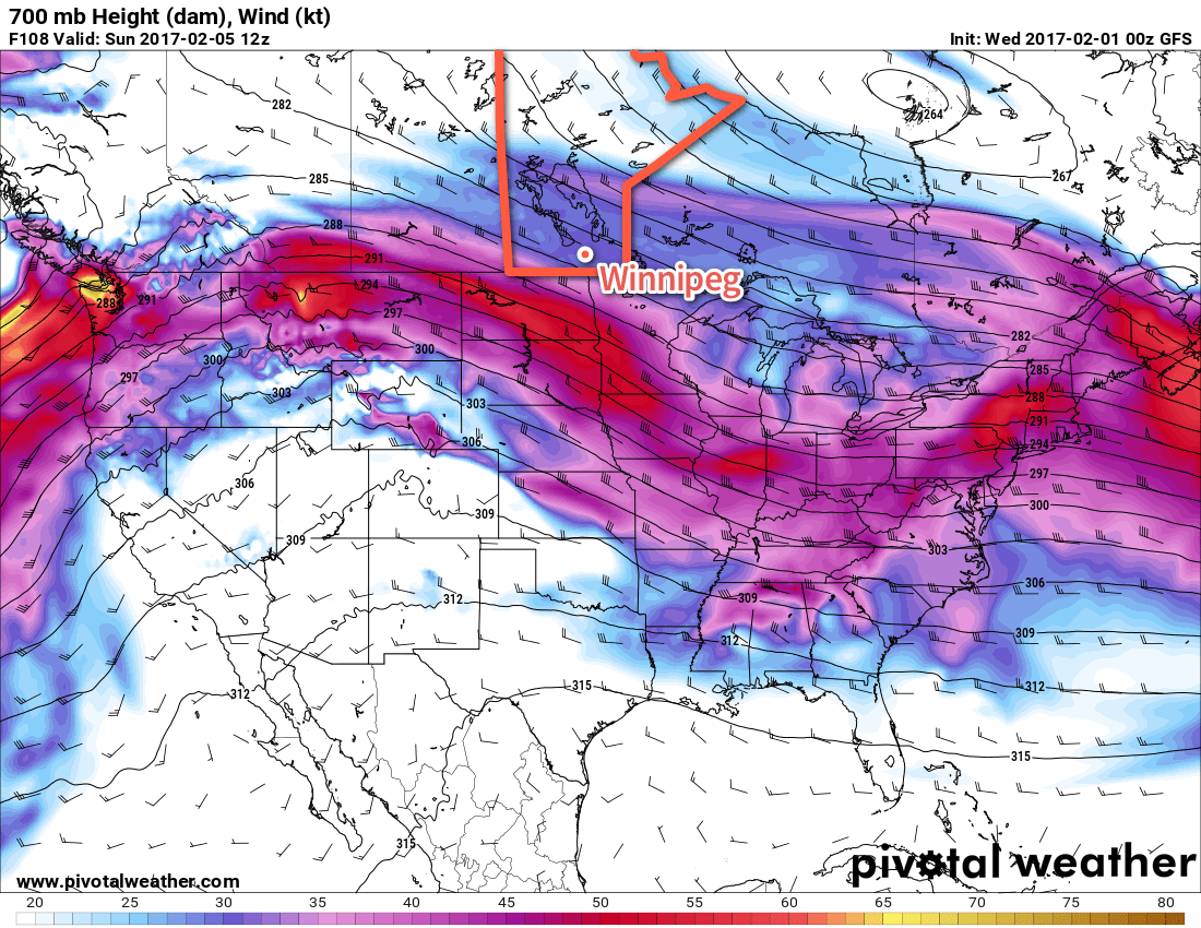
Systems will roll through roughly 18-24 hours apart, so there will be a chance for snow on Saturday, Sunday and Monday, however most of these systems look fairly weak and will be faster-moving systems. Unfortunately with the strong jet stream running west-to-east along the border, the warmest air will remain locked up to our south, and while temperatures may climb slightly above seasonal on Saturday, it will be a quick return into cooler weather once again.

There is some uncertainty as to how cold it will get once things settle down next week, but at this point daytime highs in the bottom half of the minus-teens seem fairly likely.

Winnipeg’s seasonal daytime high is currently -11°C while the seasonal overnight low is -22°C.

Sunshine Reappears With Pleasant Fall Weather

Those tired of the left-over gloom from the weekend’s weather will be happy to know plenty of sunshine is on the way as a building upper-level ridge brings seasonal temperatures and plenty of sunshine.

The weather for much of this week will be dominated by an upper ridge building across the southern Prairies, bringing pleasant conditions for the end of September with slightly above normal daytime highs. The next few days will bring plenty of sunshine with just a few clouds to partly cloudy skies expected.

Temperatures will gradually climb to around 5-6°C above seasonal by the end of the week; daytime highs near 17°C today in Winnipeg will increase to near 20°C for Thursday and Friday.

The red colours on this map of 850mb temperature anomalies shows the warmer than normal weather expected over Southern Manitoba this week.

Fortunately, it doesn’t appear the wind will pose too much of an issue either. Winds will be calm today, and then increase to around 10-20 km/h out of the south for Thursday and 15-25 km/h out of the south on Friday.

Long Range

The weekend forecast gets a little more complicated, but overall it’s looking like the weather should stay dry until the start of next week.

As the weekend progresses, a long-wave upper trough will dig over the western half of the continent. We should remain relatively unaffected by this with mild weather continuing through the weekend. Late Sunday into Monday, a shortwave will eject northeastwards out of the trough, moving into Southern Manitoba, and will bring some rain to the region. The timing of this is uncertain at the moment, but it looks likely that it won’t move into the province until late Sunday at the earliest.

So until that moves in, the weather should remain quite nice with mild temperatures and relatively light winds.

Winnipeg’s seasonal daytime high is currently 15°C while the seasonal overnight low is 4°C.

Drying Out with Seasonal Temperatures

After a rainy weekend we’ll have a chance to dry out this week as skies clear. Temperatures will be cool, but generally near seasonal values.

Cool and windy conditions are expected on Monday in southern Manitoba

This Week

Today will see mainly sunny skies as the low pressure system from the weekend moves off to the east. However, it will remain quite windy behind the system with northwesterly winds of 40 km/h gusting to 60 km/h. Temperatures will sit in the mid teens over most of southern Manitoba. There will be a slight risk of frost in low-lying areas tonight as temperatures drop rapidly with the light northwesterly flow.

Tuesday will see slightly improved weather over today as winds calm down and temperatures climb up into the mid teens. Skies will also remain mainly sunny, making for a generally pleasant day.

Wednesday should be one of the warmest days this week. Temperatures are expected to climb up near the 20C mark under light southerly winds and mainly sunny skies.

Long Range

Long range models hint at another strong low pressure system developing to our west later this week. It remains unclear if and when this system may affect us, but it likely won’t be until the weekend at the earliest. The good news is that this system will draw up a warm, southerly flow, perhaps giving us a brief stretch of warm weather before it arrives.

Ridge of High Pressure Brings Seasonal Temperatures & Dry Weather

In the wake of yesterday’s cold front that brought some wild weather to Manitoba yesterday afternoon & evening, conditions will be significantly more benign as a ridge of high pressure moves into the Red River Valley and brings dry weather with seasonal temperatures.

There is not too much to say for today’s forecast post. Mainly sunny skies will dominate the region today as a ridge of high pressure builds in from the northwest behind yesterday’s cold from that moved across the region.

A ridge of high pressure aligned through Saskatchewan into southwestern Manitoba will bring benign weather to the region.

Winds will be breezy at 20-30 km/h first thing this morning, but will fairly quickly taper off into the 15-20 km/h range. Winds will remain light through Wednesday.

Temperatures will be fairly steady with daytime highs around 23-24°C all 3 days. Overnight lows will be cool, in the 9-11°C range on Monday night and Tuesday night, however slightly milder air begins working in on Wednesday night, bumping the overnight low up towards the mid-teens.

No precipitation is expected. Skies will be mainly sunny both today & Tuesday, however a little more cloud is expected on Wednesday, with sunny skies likely giving way to more mixed conditions in the afternoon.

Long Range

The second half of the week looks to bring warmer conditions back into the region with daytime highs climbing back towards the 27 or 28°C mark with variable cloudiness. Friday evening into Saturday looks to be the first chance of any more precipitation, with thunderstorms possible. At this point, it looks most likely that they would occur overnight into Saturday morning.

So a very pleasant week ahead with little precipitation; it’s nice to finally give some good news!

Winnipeg’s seasonal daytime high is currently 22°C while the seasonal overnight low is 9°C.