Warm Weather Continues

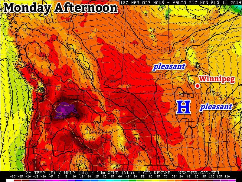
The warm, dry weather that has dominated over the past week will continue through the remainder of this week as an area of high pressure continues to stake its claim over the Red River Valley.

Wednesday
27°C / 17°C
Mostly cloudy

Thursday
28°C / 17°C
Mixed skies with slight chance of isolated showers

Friday
27°C / 15°C
Mainly sunny

Wednesday

Today will bring a fair amount of cloud, but it appears that any precipitation will likely remain west of the Red River Valley in Southwestern Manitoba northwards into the Parkland region. There will likely be a small chance of some isolated showers through the Red River Valley, but the odds look slim and even if there were, the total rainfall amounts would be minimal.

While the dry weather is generally appreciated given the wet spring and start to summer, some rainfall would be welcome in the Red River Valley. Winnipeg’s July ended as the 14th driest on record while, in general, the southwestern Red River Valley has now fallen to between 75–90% the normal accumulated precipitation for the growing season. For crops that are near harvest, the dry weather has been welcome, but some crops will be beginning to undergo some stress due to the lack of rainfall. Unfortunately, no significant rains are in the forecast in the coming week.

Percentages of the normal seasonal accumulated precipitation show below-normal rainfall developing in the southwestern Red River Valley.

Cloud and precipitation aside, today will be pleasant. Daytime highs will sit in the upper 20s with light winds. There’s significant disagreement as to what will happen overnight, though, as some models produce no precipitation whatsoever – which is what I’m leaning towards – while others develop an area of showers in the evening and move it through the Red River Valley.

While the possibility certainly exists for some rain tomorrow night, or even an isolated thunderstorm, it’s most likely that the weather will remain dry in the Red River Valley. We’ll be sure to provide an update in the comments below as things become more clear later today. The temperature will drop into the upper teens overnight.

Thursday & Friday

Warm temperatures will continue Thursday with daytime highs once again in the upper 20s. Skies will be mixed with an outside chance of isolated showers in Winnipeg & the Red River Valley. Winds will continue to be light.

Partly cloudy skies with a slight chance for isolated shower activity returns Thursday night as temperatures dip into the upper teens.

Friday will bring partly cloudy skies with a high once again in the mid-to-upper 20’s. Friday night will bring partly cloudy skies with a low in the mid-teens.

Weekend Look-Ahead

The GDPS is forecasting some rainfall on Saturday night as a weak cold front sweeps through the region.

Summer weather continues right through the weekend with plenty of sunshine on Saturday and Sunday with daytime highs in the upper 20’s. A cold front will advance through the Red River Valley late Saturday afternoon through the evening and bring a chance for thunderstorms to the region, otherwise the weekend into the start of next week looks dry.

August off to a Splendid Start

With July in the books, August looks to continue our streak of beautiful weather as an upper-level ridge continues to produce stable, warm and mostly dry weather over Southern Manitoba.

Friday
29°C / 16°C
Sunny with increasing afternoon cloud

Saturday
27°C / 13°C
Mixed skies with a chance of isolated showers

Sunday
26°C / 12°C
Mainly sunny with some afternoon cloud

It won’t take a lot of words to describe the weather over the next few days. Today will bring another sunny day that will most likely be the warmest so far this week with a high temperature approaching the 30°C mark. Clouds will roll in later in the afternoon ahead of a disturbance trundling down from the northwest Red River Valley overnight.

Tonight’s low temperature will bottom out near 15 or 16°C under partly cloudy skies. There could potentially be a few isolated showers through the Red River Valley through the overnight period, but the odds are definitely stacked against it happening.

Saturday looks like a pleasant day with mixed skies and a slight chance of showers in the afternoon through the overnight period again as a weak trough pushes through the region. Temperatures will climb into the mid–20’s for the daytime high and drop down towards low teens overnight.

Sunday will be another seasonal day with highs in the mid 20’s and overnight lows in the low teens. The day will be fairly sunny with some increasing afternoon cloud as a weak system slumps through southwestern Manitoba, bringing some shower activity to that area. Here in the Red River Valley we’ll likely remain dry, although at this point it looks like late in the day some shower activity may edge into the western Red River Valley.

None of the activity over the next few days is expected to be significant and the long-range outlook continues our seasonably warm and dry weather through much of the coming week.

Seasonal Weather Ahead

This week will feature near normal conditions as we cool down a bit from a sultry Sunday.

The weather will be mostly calm in southern Manitoba on Monday, but dangerous storms will be possible south of the border

Monday

Monday
26°C / 16°C
Mix of sun and cloud with a chance of showers

Today will feature near normal weather in southern Manitoba as temperatures climb into the mid twenties. There will be a chance of showers through the day as an upper-level impulse rolls through, but little in the way of accumulation is expected. Despite the calm weather in Manitoba, conditions just south of the border look to be quite different.

A very hot and extremely humid air mass are located over the eastern Dakotas and Minnesota today. This air mass will become extremely unstable by late afternoon, characterized by MLCAPE values of 4000-5000 J/kg (CAPE is a measure the potential energy/fuel for a thunderstorm), or perhaps even higher in localized pockets. Favourable wind profiles will allow for supercell thunderstorms and tornadoes early in this thunderstorm event, but cells will likely transition into a powerful convective system by mid to late evening. Given the potency of the thunderstorm environment tomorrow, all modes of severe weather will be possible, including very large hail and destructive winds. If your travels take you into this region today, you’ll want to pay close attention to the latest weather watches and warnings in the area.

Tuesday

Tuesday
26°C / 14°C
Mix of sun and cloud

Tuesday will be a relatively benign day. Temperatures will once again be in the mid twenties. Precipitation is unlikely as a surface high pressure system builds into Manitoba. Winds will be relatively light and from the north.

Wednesday

Wednesday
27°C / 15°C
Mainly sunny

The surface high from Tuesday looks to stick around for Wednesday, bringing continued pleasant weather to southern Manitoba. Temperatures look to be in the mid to upper twenties with light winds. Some precipitation may edge into western Manitoba late in the day as thunderstorms are potentially triggered to our west in Saskatchewan.

Long Range

The long range forecast looks to have ups and downs. Models strongly suggest that a low pressure system will move into Manitoba late this week, potentially bringing us some rain and generally unsettled conditions. Once that system exits the region we’ll likely return to more summer-like weather next week.

A Chance to Dry Out

A ridge of high pressure building into the province will offer several days of dry weather.

A break from the wet weather is finally here thanks to a ridge of high pressure that is building into the province. In a pleasant change of events, that will allow this forecast to be a whole bunch shorter than many of late.

Wednesday
22°C / 10°C
A few clouds

Thursday
25°C / 12°C
Mainly sunny

Friday
26°C / 18°C
Cloudy periods

The dry weather can’t come soon enough as the flooding situation continues to worsen over the southwestern corner of the province. Fortunately, conditions will be near-perfect over the next several days.

Today will bring a few clouds and a high in the low 20’s as the ridge begins pushing into Manitoba. Winds will be quite light today out of the northwest at around 15km/h. The temperature will drop to around 10°C under clear skies tonight.

Thursday will be a much more summer-like day with sunny skies and a high near 25°C. Winds will be light out of the southwest at only around 15km/h. Clear skies again tomorrow night as we head towards a low of 12°C.

Summer continues its return on Friday as temperatures climb a degree or two higher than Thursday. We’ll see a few cloudy periods as a warm front pushes towards the province. The temperature will fall to around 17 or 18°C on Friday night with a few clouds.

Blistering Weekend Ahead

Looking ahead to the weekend, there is only one word to describe it: hot. A very hot and humid air mass will build into southeastern Saskatchewan on Friday and then spread eastwards into Manitoba on Saturday. High temperatures will be in the lower 30’s on Saturday while dew point values climb into the 21-24°C range. The heat and humidity will combine to likely produce humidex values over 40 on Saturday. Needless to say, that is swelteringly hot and will firmly remind people that we are, in fact, in the middle of summer.

Sunday will continue to be hot until a cold front sweeps through in the afternoon. Temperatures will climb into the upper 20’s or just break 30°C which will feel more like the upper 30’s thanks to the humid air still present in the region. Slightly cooler and drier air will move in for Sunday night and next week as the winds shift westerly behind the cold front.

Any storm potential for the weekend is still unclear. To some degree severe storms are always possible when such hot and humid air pushes into our region, but at this point there simply isn’t a clear indicator as to whether anything will develop. We’ll have more on it later in the week.

Enjoy some dry weather and, finally, a real taste of summer!