The difference between the weather experienced last week and that which is coming for early this week will be quite extraordinary. Temperatures on Monday look to be nearly 20 degrees cooler than values experienced last week.
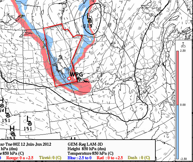
850mb temperatures (about 5000ft above the ground) are forecast to sink to near or below zero degrees on Monday
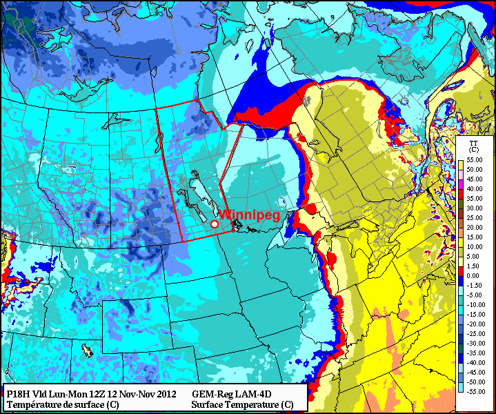
High temperatures on Monday are not expected to stray far from the 10C mark in Southern Manitoba. Eastern most sections in the south may manage to hit the mid teens, but the rest of Southern Manitoba shouldn’t be much warmer than 10 degrees. This comes as quite a contrast to the 30 degree temperatures of last week. The above graphic shows the extent of the cold air, with freezing temperatures just 5000 or so feet above the ground. We will most likely see some shower activity develop across Southern Manitoba on Monday, but amounts should be relatively light in most areas. Thankfully Tuesday and Wednesday will be warmer, with highs moving sharply higher. Tuesday should be near or above twenty degrees (depending on which model you believe), while Wednesday is expected to be in the low to mid twenties. There may be some convective rain and/or thunderstorms on Wednesday as humidity levels increase ahead of an approaching low pressure system.
The Preliminary outlook for later this week is for more warm to hot weather. Highs back in the middle or upper twenties will be possible on Thursday and Friday according to the latest modelling. However, my confidence level in the late week forecast is lower than normal since there is some uncertainty as to how quickly a series of fronts will pass through the province late in the week. Given my lack of confidence in the Thursday-Friday forecast I won’t say much about the weekend. You can read more about longer range predictions in the next paragraph.
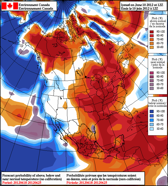
The long-range forecast calls for above-normal temperatures in Southern Manitoba for the second half of June
The NAEFS forecast seen above shows the long-range temperature forecast for the June 18-25 period. It appears that we will stick with above-normal weather for most of the second half of June. Also note that we are on the edge of the warmest air, meaning that approaching systems coming out of the colder air to our west (a trough) could potentially trigger strong thunderstorms as they interact with the warmer air to the east. This type of trough-meets-ridge pattern is to blame for the severe thunderstorms on Saturday night.
AWM Chases!
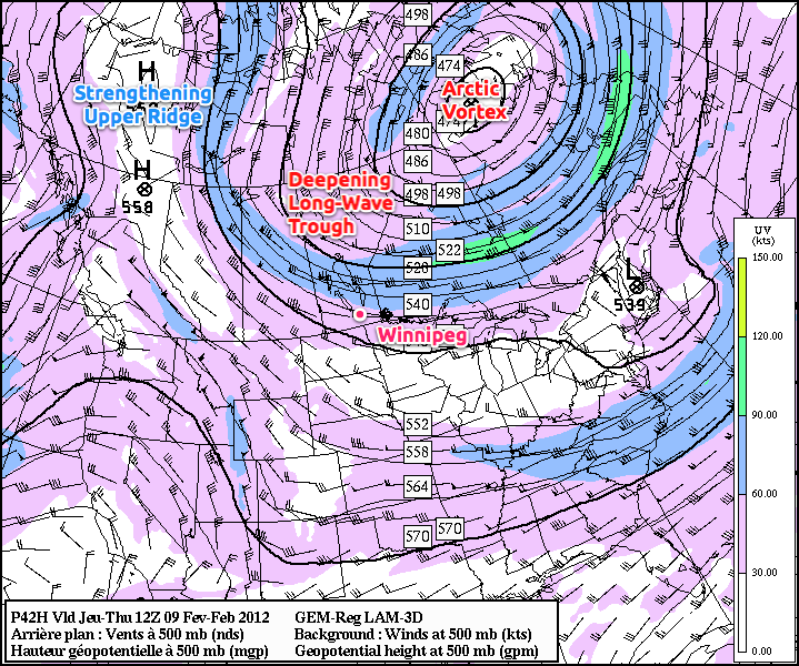
The A Weather Moment team took to the highways of Southern Manitoba on Saturday for our first chase of the year. Hot and humid surface weather combined with an approaching low pressure system and a strong jet stream aloft made conditions ripe for severe supercells thunderstorms which could potentially produce tornadoes.
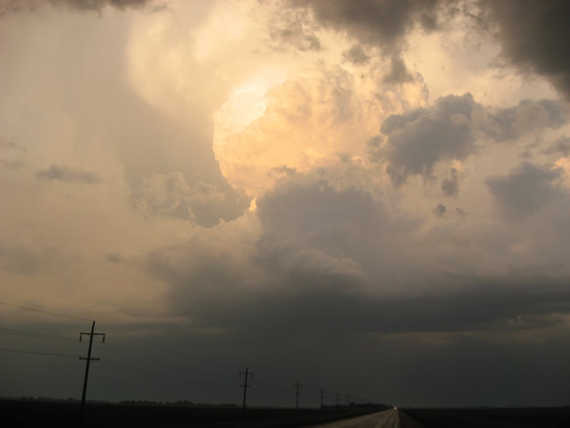
A thunderstorm east of Altona on June 9, 2012
The AWM team decided to drive toward Holland, MB to start the day. After arriving in Holland it was decided that Pilot Mound would be an appropriate new target given the new weather information available. Upon arriving in Pilot Mound and watching the latest weather conditions evolve we felt our location was ideal. At that point it was time to wait…and wait..and wait. After watching numerous towering cumulus clouds fail to breach the cap we decided to abandon Pilot Mound and follow some storms to our east which were approaching the Red River Valley. As we began to get a good visual of the storms around the Altona region it was clear that there was little chance of a tornado. Cloud bases were high and there were no significant lowerings to be found – the storms were elevated – not surface-based tornado producers. Nevertheless we stopped for awhile near Altona to take a closer look at the storms, a look which revealed nothing of significance. Having taken a few anvil and sunset photographs it was time to head back toward Winnipeg, just missing the infamous hailstorm (which put down tennis ball sized hail) that hit the city around sunset.
Overall it was a good chase. It was not a complete bust since there were storms, but it was definitely a bust in the fact that tornadoes were really nowhere to be found (I’ve kept the door open here for you to decide whether or not this is a tornado: http://tornadohunter.ca/tornado-hunter-blog/2012/6/10/the-longest-chase-day-ever-but-we-got-a-tornado.html). It is only early June and the severe weather season is just beginning, the next chase will be here before we know it.
The AWM team (Brad, Scott and Matt) would like to thank the 311 unique visitors who made 624 visits to this website yesterday, a new record number of visits for this website. Thank-you.