This week will feature the coldest weather we’ve seen since last winter, just what you were hoping for I’m sure!
Monday
Monday
-12°C / -16°C
Clearing
Skies will clear on Monday morning, giving way to a sunny, but cold day. High temperatures will be in the minus teens with a brisk north-west wind. Watch out for slippery sections on the roads, as freezing drizzle and snow from yesterday will certainly still be an issue on untreated surfaces.
Tuesday
Tuesday
-9°C / -17°C
Mainly cloudy with chance of flurries
Tuesday will be one of the warmer days this week (if you can believe it). Temperatures will hover around the -10C mark with a chance of flurries throughout the day. The mainly cloudy skies will be partly responsible for the warmer conditions, trapping heat near the surface. Winds will be fairly light and from the north-west.
Wednesday
Wednesday
-18°C / -30°C
Mainly Sunny
Wednesday looks to be the coldest day since last winter as a strong surface high descends into southern Manitoba. High temperatures will barely crack the minus teens and lows on Wednesday night could approach -30C. A brisk northerly wind will add a decent wind chill factor as well, making it feel even colder, if that’s possible!
Long Range
The long range forecast looks awful, so there’s barely any point even talking about it. Temperatures look to remain below seasonal for the foreseeable future…hopefully you’re ready for winter, because it’s here!
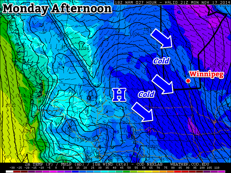
This week will remain cold as arctic air continues to spill down from the north.
A northwesterly flow will continue to bring cold weather to southern Manitoba on Monday
Monday
Monday
-8°C / -14°C
Mix of sun and cloud with chance of flurries
Today will be cold and breezy. Temperatures in the morning will be in the minus teens, rising into the minus single digits by afternoon. Skies will be a mix of sun and cloud with chance of light flurries. The wind will be from the north-west at 20-30km/h.
Tuesday
Tuesday
-7°C / -10°C
Mix of sun and cloud with chance of flurries
Tuesday will be slightly warmer than Monday, but not by much. High temperatures will once again be in the minus single digits, once again under a mix of sun and cloud. There will also be a chance of light flurries throughout the day. Winds will be breezy and from the south.
Wednesday
Wednesday
-9°C / -18°C
Mainly cloudy with flurries
Wednesday looks to be a fairly miserable day. High temperatures will be near the -10C mark, with a gusty north-west wind and flurries. This means blowing snow is likely in open areas, similar to the conditions experienced on Sunday. Winds speeds of 40km/h gusting to 60km/h are expected.
Long Range
The long range forecast calls for continued cold weather. Weather models suggest that we’ll see below-normal weather persist for at least another week. Unfortunately, it looks like winter is here to stay, like it or not.
This week will see one last wintry blast in southern Manitoba before spring finally arrives for good.
A surface ridge of high pressure will bring cold weather to southern Manitoba to start the week
Monday
Monday
-7°C / -18°C
Mainly sunny. Chance of flurries.
Today will likely be the coldest day of the week. High temperatures will be in the upper minus single digits, with a chance of flurries. This chance of flurries will arise from low-level instability that will develop as the surface warms during the day. To top it all off, there will be a breezy north-west wind – great!
Tuesday
Tuesday
-5°C / -15°C
Increasing cloudiness. Slight chance of flurries.
A low pressure system will pass to our south on Tuesday, allowing a cool north-easterly flow to remain established over southern Manitoba. Luckily, that system should remain far enough south to prevent us from seeing any more snow, although a couple of flurries can’t be ruled out.
Wednesday
Wednesday
-4°C / -17°C
Mix of sun and cloud. Chance of flurries.
A brisk northerly flow will remain in southern Manitoba on Wednesday, making for another cold day. High temperatures will be in the mid minus single digits, and there will once again be a chance of flurries.
Record Cold?
With the cold weather that’s expected this week, we will be challenging some cold weather records. The table below shows the record values for the next several days:
Record Cold Minimum and Maximum Temperatures
Date
Record Low
Record Cold High
Monday April 14
-16.7°C (1893)
-7.8°C (1880)
Tuesday April 15
-16.7°C (1893)
-6.7°C (1875)
Wednesday April 16
-16.7°C (1875)
-4.4°C (1910)
Thursday April 17
-13.3°C (1953)
-3.3°C (1953)
It looks like we will come close to setting new records on each of the days listed in the table. Stay tuned to see if we manage to actually break any records!
Long Range
The long range forecast calls for increasing temperatures as we move into the weekend. We’ll likely see seasonal temperatures (i.e. low teens) return by the weekend into next week. There is currently no strong prospective of above-normal weather, but we’ll probably see at least a couple seasonably warm days before the month is out.
Record Low Temperatures Broken
A large swath of record low temperatures were set on the morning of April 15, 2014 across the province of Manitoba thanks to a strong Arctic ridge of high pressure sprawled over the region. Overnight lows were 10-20°C below normal throughout the province. Winnipeg did not set a new record low, however some other locations in the Red River Valley did.
Record Low Temperatures set on April 15, 2014
Site
New Record
Old Record (Year)
Berens River
–23.8°C
–19.6 (1997)
Carberry
–14.2°C
–12.9 C (2000)
Carman
–15 C
–11.4 C (2000)
Fisher Branch
–20.4 C
–11.8 C (2000)
Flin Flon
–20.5 C
–16 (1997)
George Island
–19.5 C
–16.8 C (1997)
Grand Rapids
–24.4 C
–13 (1997)
Island Lake
–20.7 C
–20.6 C (2000)
McCreary
–13.7 C
–12 (2000)
Oak Point Marine
–19.7 C
–11.9 (1997)
Pinawa
–21 C
–12 (2000)
Roblin
–11.4 C
–11.3 C (1997)
Shoal Lake
–11.5 C
–10.2 C (2000)
Sprague
–16 C
–10.8 C (2000)
The Pas
–20.5 C
–18 C (1986)
Thompson
–27.3 C
–23.4 C (1985)
Victoria Beach
–20 C
–11 C (2000)
Wasagaming
–15.5 C
–15 C (1978)
More record lows will be at the risk of being broken as the week progresses.
There aren’t too many positive things one can say about this March so far. It’s been cold, it’s been snowy, and there’s still a week of it left. Unfortunately for us, this March will end just as it started – like a lion.
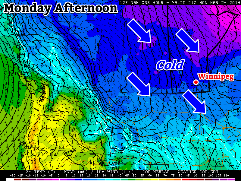
Monday will see more cold weather in southern Manitoba
Monday
Monday
-10°C / -24°C
Increasing Cloudiness. Chance of Flurries.
Today will see the continuation of well below normal weather. This morning’s lows were more akin to January than March and today’s highs will be similar to the normal lows for this time of year. That is to say we’ll see highs near the -10C mark, with this morning’s lows having been in the -20s. If the cold wasn’t bad enough, we may even see a bit of snow along a cold front today – just what you were hoping for I’m sure. This cold front will usher in some gusty north-west winds too, so any snow that does fall will be sure to blow around a bit.
Tuesday
Tuesday
-11°C / -20°C
Mainly Sunny
Tuesday will be similar Monday temperature-wise with temperatures once again well below normal. It will be a bit less windy than Monday however, with little threat for snow, which will make it slightly nicer day overall.
Wednesday
Wednesday
-6°C / -10°C
Flurries possible
Wednesday looks to be one of the warmest days this week, with highs in the mid single digits. This warmer air will be brought north by a low pressure system passing to our south. This low pressure system may even bring some snow to southern Manitoba, but it’s too early to say.
Long Range
The long range forecast continues to look abominable. Long range models continue to strongly suggest that below-normal weather will last at least through the end of March. At this point we can only hope that April will see some improvement.