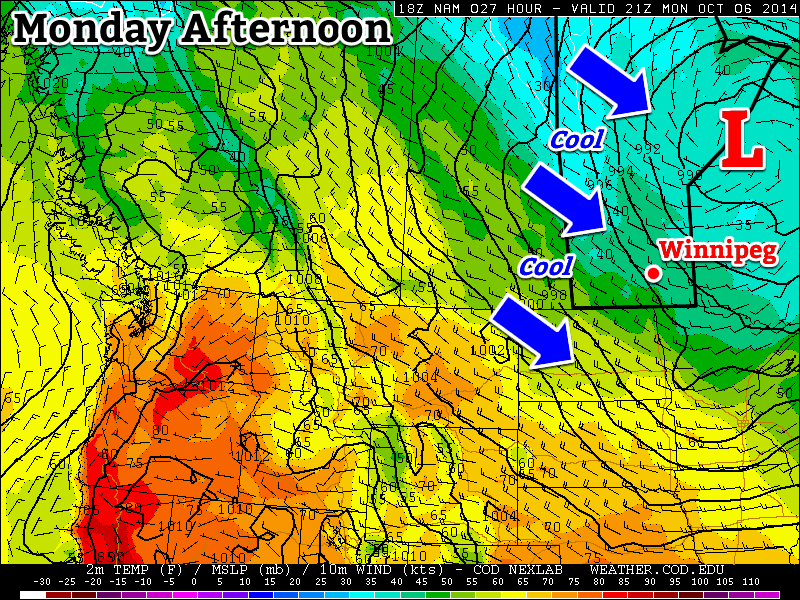
A large upper-level low pressure system over northern Ontario will bring us chilly weather to start the week. Unfortunately, this means below-normal temperatures and frequent opportunities for showers.
An upper low over Ontario will bring cool conditions to southern Manitoba this week
Monday
Monday
7°C / 2°C
Mainly cloudy with chance of showers
Today will be cool, cloudy, and breezy as that large upper-level low over Ontario brings a cool north-westerly flow to southern Manitoba. There will be a chance of showers throughout the day, as a band of light precipitation pushes down from the north.
Tuesday
Tuesday
7°C / -1°C
Mainly cloudy
Tuesday’s weather will be very similar to today’s. Skies will once again be mainly cloudy with a chance of showers. Unfortunately, it will also remain breezy as that upper low to our east maintains a decent pressure gradient across Manitoba.
Wednesday
Wednesday
8°C / -3°C
Mix of sun and cloud
It looks like Wednesday’s weather may begin to see some improvement over the conditions from earlier in the week. Temperature won’t warm by much, but winds should be a bit lighter. The chance for showers looks to be gone on Wednesday, and we should even see some sunshine.
Long Range
The long range forecast isn’t looking all that great at this point. The current forecast calls for a surface high to build into Manitoba late this week as that nasty upper low finally moves off. This will likely mean sunnier skies, but also a good chance for some solid freezing nights, and relatively cool daytime temperatures. Models hint at a warming trend from next weekend into the following week, though it isn’t currently expected to be an extended warm-spell…but we shall see what actually happens!
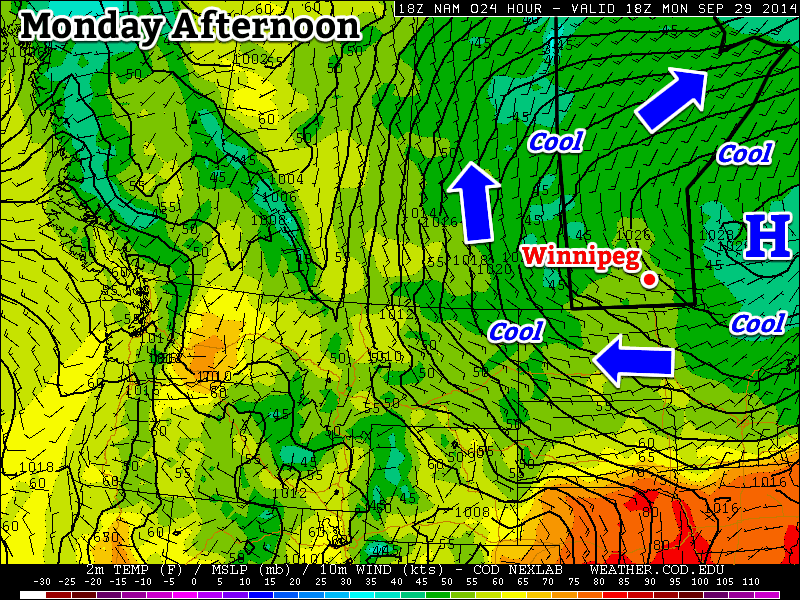
After a week of summer-like weather, conditions will return to reality. More fall-like temperatures are expected this week along with some rain.
Cool conditions will dominate our weather on Monday
Monday
Monday
12°C / 8°C
Mainly cloudy
Today will be mainly cloudy with a chance of an isolated shower or drizzle. Low-level moisture under a strong ridge of high pressure will be responsible for the cloud. We may see some clearing late in the day, but that won’t change the day’s expected temperatures. High temperatures today will be in the low teens, with a light easterly to south-easterly wind.
Tuesday
Tuesday
16°C / 10°C
Mainly cloudy
Tuesday will remain on the cool side, with temperatures in the low to mid teens. Despite the fact that these temperatures may seem cool, especially compared to last week, they are actually near normal for this time of year. Our next chance for rain will begin on Tuesday night as a compact, but intense, low pressure system spreads rain over southern Manitoba.
Wednesday
Wednesday
18°C / 8°C
Periods of rain
The aforementioned low pressure system will be the dominant weather feature on Wednesday. It is expected to bring light to moderate rainfall to southern Manitoba for most of Wednesday. It is too early to predict how much rain will fall, but at this point 5-10 mm looks most probable.
Long Range
The long range forecast looks very fall-like. Current modelling suggests we will see normal to below-normal weather as we move into October. That means temperatures in the low teens, plus or minus a few degrees.
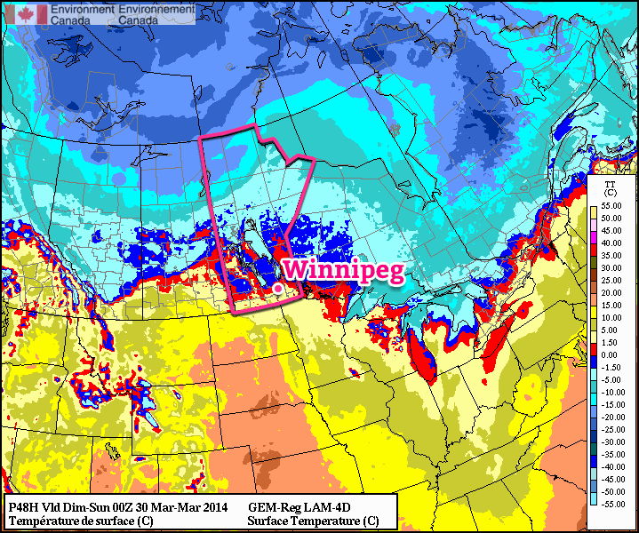
Temperatures are forecast to rise above 0°C by Saturday evening.
A low pressure system moving through the region on Saturday will bring a chance of snow and only slightly below normal temperatures to Winnipeg, however another Arctic ridge will plunge southwards behind the system returning us into the icy grip of winter as temperatures fall 10 to 15°C below normal. This is starting to look very similar to last year: the winter that wouldn’t quit, until suddenlyit did. This December to March period will go down as one of the top 15 coldest on record, and not a single one of those top 15 coldest winters was followed by a notably above-normal April[1]. This means while milder weather is on tap, we’ll likely only be looking at returning to near-seasonal averages, especially while we still have such a significant snow pack on the ground.
Today will see temperatures climb to around -5°C by the late afternoon despite our fairly cold start this morning. Such large swings in temperature now are possible because our cold air is in a thin layer right near the surface[2] and the increasingly strong March sun is more able to effectively warm up all of the cold air. Winds will be light as we sit right underneath a ridge of high pressure.
Friday
-5°C / -13°C
Sunny.
Saturday
+1°C / -3°C
Mostly cloudy. Chance of light snow.
Sunday
⇓ -6°C / -20°C
Chance of flurries in the morning, then clearing & windy.
Saturday will be the warmest day we see for a while but unfortunately the weather won’t be all that pleasant to be outside. The temperature will start off around -13°C or so first thing in the morning and begin to climb as the approaching low pressure system pushes warmer air over the province ahead if it. The low pressure system will be running into a fairly stubborn ridge, however, and by mid-morning winds will begin to pick up and climb to 30-40km/h by the early afternoon with gusts to nearly 60km/h. A warm front should lift northeastwards through the Red River Valley through the afternoon, and temperatures behind the front will climb just over the freezing mark to around +1°C.
There will likely be some light snow produced ahead of the warm front as it lifts northeastwards, however right now it looks fairly weak and disorganized with no significant amounts expected. Skies will remain mixed-to-mostly-cloudy Saturday night as the temperature drops to around -2°C. The stronger winds will taper off behind the warm front and light winds are expected throughout the night.
Sunday will start off cloudy with a slight chance of flurries as the cold front associated with the system pushes through the region. Behind the cold front skies will clear and gusty northerly winds to 30-40km/h will pick up. The breezy winds will usher colder air into the province and temperatures will fall to around -5 or -6°C by Sunday evening. Temperatures will drop to around -20°C, or perhaps a bit colder, under clear skies on Sunday night.
That hope on the horizon? Still there!
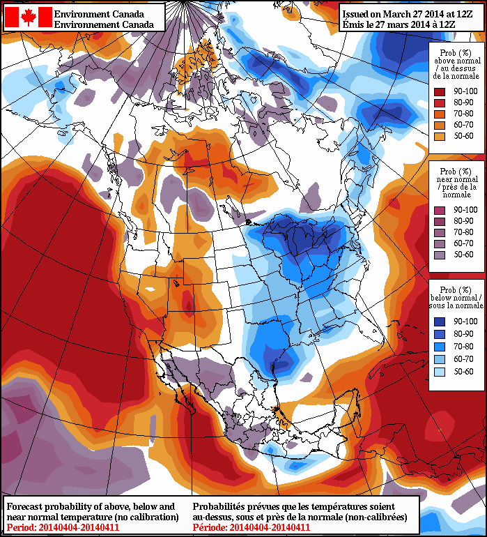
On Wednesday we mentioned that there was some hope on the horizon for warmer weather, and it’s still there! The latest NAEFS 8-14 day temperature anomaly forecast is showing a general push towards seasonal temperatures across much of the Prairies as April gets going. Temperatures are forecast to climb into the low single-digits by the middle of next week, and the general “near normal” trend of the NAEFS hints that we may actually be heading into a more prolonged period of seasonal weather with daytime highs above 0°C.
The NAEFS 8-14 day outlook is showing near-normal temperatures for Southern Manitoba.
Anything to melt the snow will be a welcome site to winter-weary Winnipeggers. As pointed out over by JJ over at his Winnipeg Weather blog, this December to March period will be the coldest one in 115 years with the next coldest being the winter of 1898-99. With last night’s low dropping below -20°C, Rob pointed out over at Rob’s Obs that it will mark the 15th time this month temperatures have dropped below -20°C; typically that only happens 5 times in March.[3]
The 1872 to 2013 mean temperature – an average of both the highs and the lows – is 3.5°C. ↩
Instead of a very deep layer, like we would see in January or February. ↩
Apparently I’ve dropped the ball by waiting until March was <em>over</em> before calculating my March statistics! ↩
The weather this week will be cool and calm, meaning no big weather makers are in the forecast.
Early Week
Monday Mix of Sun and Cloud. Slight Chance of Flurries. 4°C / -1°C
Tuesday Mainly Cloudy 2°C / -8°C
Wednesday Mainly Sunny 0°C / -8°C
Monday will be a seasonably warm day in Southern Manitoba. A cold front will pass through in the morning, causing the wind to shift to westerly. Temperatures will be in the low to mid single digits.
Tuesday should see seasonable conditions continue in Southern Manitoba. Temperatures will be in the low single digits with a light westerly wind.
Wednesday will be very similar to Tuesday, with temperatures once again in the low single digits and winds being light.
Long Range
The long-range forecast looks to feature mostly seasonal weather. However, we’ll likely see our first snowfall of this fall at some point in the next 5-10 days. It probably won’t be a significant snowfall, but a snowfall nonetheless.