Warm Start to the Week

This week will start out seasonably warm, a nice turn-around after a cool end to last week.

The Weather will be Nice in Southern Manitoba on Monday

The Week Ahead

Monday

Mainly Sunny
16°C / 6°C
Tuesday

Mix of Sun and Cloud
20°C / 6°C
Wednesday

Mainly Cloudy
16°C / 7°C

Today will be a nice day in Southern Manitoba. Temperatures will be in the mid teens under sunny skies. The wind will be light as well, making for all around pleasant conditions.

Tuesday will once again see mild conditions in Southern Manitoba. There may be a bit more cloud compared to Monday, but temperatures are still expected to be warm, with highs in the upper teens or low twenties. Tuesday will be a bit windier than Monday, but even so the wind won’t be a big issue.

Conditions will change little for Wednesday. Temperatures will once again be in the mid teens in Southern Manitoba with light winds. Wednesday will be a cloudier day however, as a weather system to our south spreads some cloud cover over Southern Manitoba.

Long Range

The weather for the late week period is looking a bit interesting. A large low pressure system is currently forecast to move through Southern Manitoba towards the weekend. At this point it appears precipitation from this system will be mostly rain, although some flurries may be possible as it exits the region. More details on this system will be available later in the week.

Beautiful Start To Fall Continues

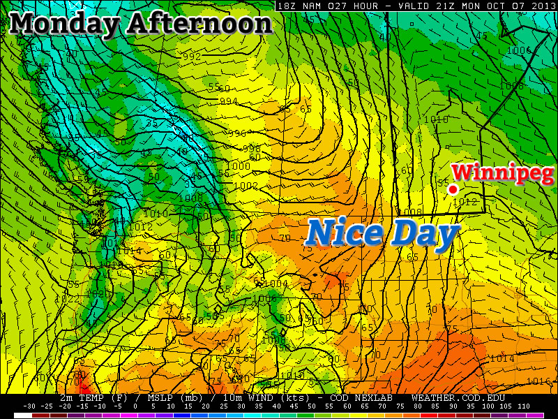
Our beautiful start to fall – a start that has seen two days in a row a full 9–10°C above normal – will continue with well above-normal temperatures continuing through the week. A powerful storm system moving into Saskatchewan will lead to more unsettled weather as we move towards the end of the week, but rain is far from guaranteed here in Winnipeg.

Wednesday

Wednesday

25°C / 16°C
A mix of sun and cloud; windy out of the south.

We’ll see another pleasant but breezy day today under a mix of sun and cloud as some patchy cloud cover moves eastwards from a powerful storm system taking shape over central Saskatchewan. Temperatures should climb to around 25°C this afternoon as gusty winds pick up to 30–40km/h out of the south. The winds will let up a little bit overnight but will still be noticeable which, when combined with increasing cloudiness, will conspire to keep our overnight low around a balmy 16°C – which is coincidentally the average daytime high for this time of year.

Thursday

Total accumulated rain from the GDPS on Thursday 12Z - 00Z.

12 hour rainfall accumluations depicting rainfall during the daytime on Thursday. Under 2mm is forecast by the GDPS for Winnipeg.
Thursday

24°C / 12°C
Cloudy with gradual clearing. Chance of showers midday through the afternoon.

Thursday will bring mostly cloudy skies as the Saskatchewan storm edges eastwards slowly. While showers will push in over Western Manitoba, here in Winnipeg we’ll see just a slight chance of seeing some shower activity. The chance will start midday and last through much of the afternoon, but if we do get any rain it shouldn’t accumulate to anything significant.

The day will start mainly cloudy, but we should see mainly sunny skies by the evening as everything lifts off to the north. Our temperature will climb to around 24°C with winds around 30km/h diminishing through the afternoon. Thursday night will start with mainly clear skies but we’ll see increasing cloudiness by Friday morning as cloud streams in from the southwest ahead of yet another disturbance.

Friday

Friday

18°C / 7°C
Cloudy periods. Very slight risk of a morning shower.

We’ll see some cloudy periods on Friday as another disturbance spreads cloud ahead into Southern Manitoba. Our temperature will be a bit cooler; the daytime high is expected to hit around 18°C as a cold front pushes across the Red River Valley.

Friday night holds some promise of seeing some precipitation, which is rapidly becoming needed in Winnipeg. Only 4mm of rain has fallen in Winnipeg so far this September, not even 10% of the average of 45.5mm that falls in this month. The last significant rainfall in Winnipeg was the heavy thunderstorms that occurred through the morning of Sunday, August 18th which brought 15–30mm to the city. Since then, only 6mm of rain has fallen.

The GDPS is currently the only system that’s bringing rain into Winnipeg on Friday night, however there are some indications that other models could begin to fall in line with that thinking as well. Unfortunately, it’s going to be yet another system that has a very sharp cutoff on it’s edges. This system will be very sensitive to track, so we’ll be sure to keep an eye on things as they develop. Be sure to check back in the comments below for updates closer to the weekend.

Elsewhere in Weather News: August 24th, 2013

California Wildfires Threaten National Park

A small wildfire started about a week ago in the back country trails of the California forests near Yosemite National Park has now turned into a raging wildfire. The wildfire which was initially located outside park boundaries has recently encroached on the national park territory. Covering about 425 square kilometers, the fire is only 2% contained bringing concern to many residents in the area who are under voluntary evacuations. Twelve buildings have been damaged or destroyed by fire already and another 4,500 around Yosemite are at risk. In all, 7,000 firefighters were brought in to battle the wildfire.

Wildfire smoke

Visible satellite shows extensive amount of smoke in eastern California. Smoke outlined in orange, red the location of the Yosemite fire. (Source: CoD satellite)

Very dry heat has been in place over the region for the last week priming the conditions for wildfires. Relative humidity values are expected to remain in the single digits, combined with temperatures in the mid to high twenties, no relief will be provided to the firemen battling the blaze. Drought has persisted since the beginning of summer for much of California and as of Friday 98% of the state is experiencing drought, with the severity ranging from moderately dry to extreme. Due to the dry conditions, 15-20 large wildfires are currently burning in California.

Usually, the wildfire risk peaks in late September in California as the Santa Ana winds come into play. Santa Ana winds are severe winds that are funneled through the mountains. As these winds are funneled through and descend in height (moving towards the coast) they are heated by natural processes, namely, adiabatic heating, causing for extremely hot and dry weather. These easily spread wildfires by blowing embers towards flammable vegetation.

Elsewhere in Weather News: November 17th, 2012

Wildfire Flare Up in Southern Australia

On Monday the 12th of November, a large wildfire in Southern Australia flared up. Residents had to be evacuated in the region of Tulka as the wildfire threatened houses. Over 100 firefighters battled the blaze but unfortunately they were unsuccessful in their attempt to control it that day. In total, the fire burned nearly 5,000 acres, destroying seven properties. No one was injured, though animals such as koalas that lived in the area where the wildfire took place needed veterinary attention. The fire has been contained since Tuesday.

Wildfire

Picture of the Tulka Wildfire. (Source: Michael Sleep/ABC)

This month, Port Lincoln, a city near Tulka, received only 4.4mm rain in comparison to its 20mm average for the month of November. The lack of precipitation combined with a high of 36.4°C on Sunday November 11th (13°C above the November average) contributed to conditions ripe for wildfires in Southern Australia at this time of the year. Tulka typically receives minimal rainfall in the month of November due to dominant high pressure off the coast of Southern Australia and troughs that sporadically make their way to the region. It is predicted that most of Australia will have a warm and dry summer, having an indirect relation to the weak El Nino that is forecast to develop this winter. If this were the case, it would be an active wildfire season in Australia this summer.

Systems map

Systems map of Australia of next Wednesday, high pressure dominating Southern Australia. (Source: Weatherzone)

Several days prior to this event, a few other wildfires flared up in Western Australia but they were located in a remote area and did not directly affect population.

Wildfire NASA picture

Picture of a wildfire in Western Australia on November 7th, taken by NASA. (Source: NASA)