Unsettled Weather On The Way

A broad trough of cold air aloft is set to park itself over Manitoba the next couple days, preventing any warmer air from spilling eastwards and keeping us cool, cloudy and slightly snowy.

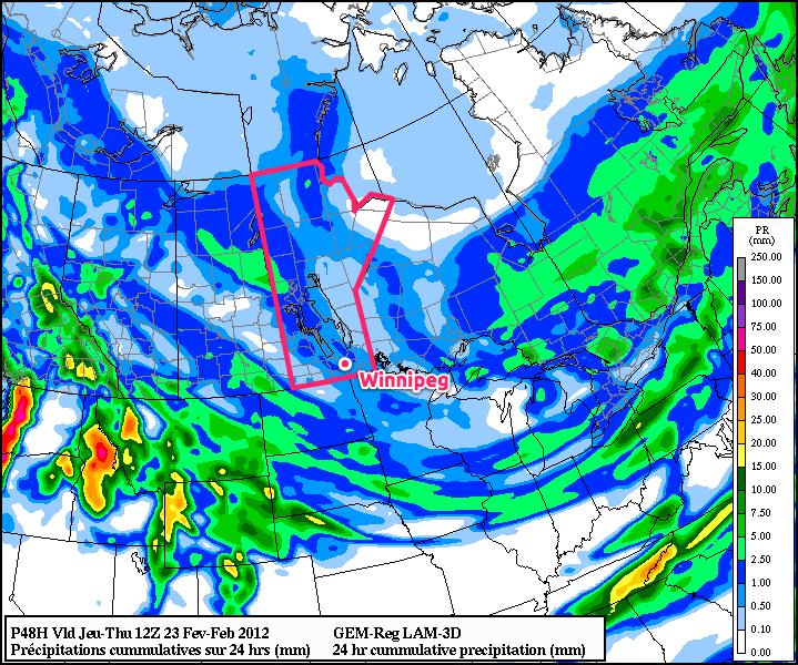
24 Hour QPF Accumulation

24 Hour QPF Accumulation valid 12Z Thursday morning. This shows the total precipitation accumulation from 12Z Wednesday morning to 12Z Thursday morning.

A weak, broad upper trough will build over the province as a northerly at all levels provides cold air reinforcement. The general instability produced by the trough, combined with a slowly advancing cold front over the Interlake and a weak shortwave sliding across SW Manitoba from Saskatchewan, will produce plenty of cloud and occasional flurries. None of these features should generate significant snowfall, reflected by the generally meagre amounts produced by the model (<1mm of liquid equivalent over Southern Manitoba). Temperatures will remain relatively mild, moderated by the cloudy skies we’ll see for the rest of the week. Daytime highs should sit right around -5°C and overnight lows should be right around -10°C.

The cold front, after staying relatively stagnant for a few days, will push southwards this weekend as an upper trough swings southwards out of the Arctic. This should provide us with some sunny skies, but drop our temperatures down in the the -10°C to -15°C range for daytime highs with overnight lows closer to -20°C. By the end of the weekend, Southern Manitoba has another chance at snow, as a moderately strong low pressure system sweeps across the Northern Plains.

The general long-range forecast shows that after this slightly-above-average temperatures week is over, we’ll switch back into a slightly below-normal temperature pattern with daytime highs on the cold side of -10°C, with the possible return of overnight lows south of -25°C. Will March come in like a lion? We’ll have to wait and see…

Weather? What Weather?

Our exceptionally unexceptional February continues with very little in the way of weather. After a mild, but dull, day today we’ll be back to sunshine and seasonal to slightly above seasonal temperatures.

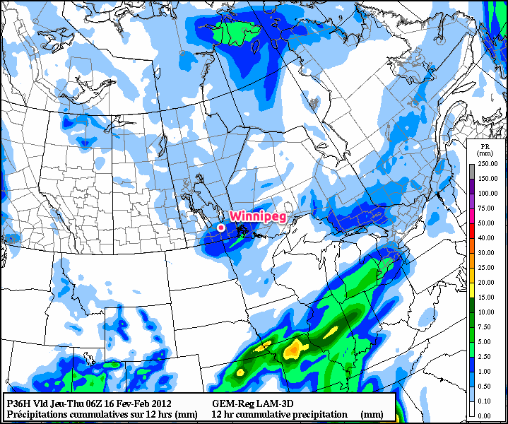
Precipitation Outlook

12hr. QPF from the GEM-REG, valid at 06Z Thursday February 16 (1AM Local Time)

A very weak upper trough is moving over the region today, bringing with it cloud and a slight chance of flurries. The risk is greatest in areas south of the Trans-Canada Highway, from The Brandon/Pilot Mound regions eastwards into the Whiteshell. SLRs are expected to climb up to 15:1 to 20:1 range, so some areas closer to the US Border or into the Whiteshell may see as much as 2cm of snow. It’s unlikely that Winnipeg will see even 1cm of snow today.

The rest of the week will be sunny with daytime highs near -3°C and overnight lows near -10°C. There’s a slight chance of some snow on the latter half of the weekend, but we’ll leave that for discussing on Friday.


Updates to the Mobile Site

Some of you may be familiar with the U of M Weather Central: Mobile site that I maintain. Well, (in a Professor Farnsworth voice)…

Good news, everybody!

I’m working on updating the site as we speak. It’s no small task, as it’s a pretty comprehensive site, but I’m working on making it better than ever! A task which doesn’t seem too difficult, given I made the old one (which serves its purpose adequately) while learning how to code. Anyways, here are my goals for the redesign:

  • Utilize the latest mobile technologies to provide a modern, compelling experience that is well-supported across the mobile space (iOS, Android, Windows Phone 7).
  • Improve the page layout and design to visually group information better and to provide quick access to all available information.
  • Utilize responsive design so that the page layout will optimize itself for phones, iPads, or desktop computers!
  • Fix long-standing bugs from the old code (incorrect forecast icons, among others).
  • Enhance existing features. One example is that the site now uses the sunrise and subset times of a city to calculate when to change from daytime to nighttime imagery.
  • Broaden Canada-wide support.
  • New features! Mobile model viewer! Mobile satellite Viewer! Mobile RADAR viewer! And more!

These are the main goals. The biggest hurdle is moving everything from a pure PHP solution to a tightly integrated jQuery/PHP solution. I plan on developing what will essentially be APIs to retrieve the data and provide a JSON-encoded response. What does that mean? The site will be fast, versatile, and standards-compliant. I also plan on making the .PHP files public so that people can easily access select Environment Canada data in a practical, modern way.

I think this new site will be really great and hands down the number-one way to get weather data on the go (and hopefully it’ll be good enough you’ll use it at home too!).

A Cooler Week Ahead

A cooler week is in store for us as we move into the last month of meteorological winter. Temperatures don’t, however, look like they’ll be too far from normal through most of the week.
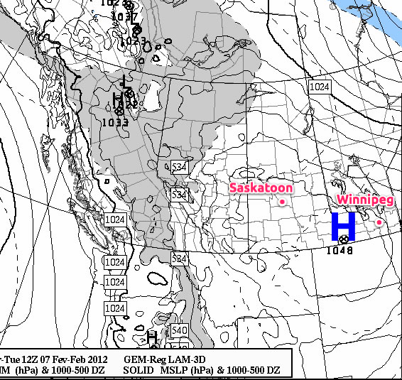
Surface Pressure Map

Surface Pressure Map – valid 12Z Tuesday, February 6, 2012

With the passage of a cold front this morning, gusty northerly winds will usher colder air into Southern Manitoba. As a result temperatures will fall throughout the day today, with midday conditions in the mid-minus single digits. There will be a few scattered flurries this morning through Southern Manitoba as the cold front works its way through the area, however there will be no significant accumulations with them. Tonight, a strong area of high pressure will build into Southern Manitoba, with the central pressure expected to be as high as 1045mb. This will bring significantly colder temperatures than we’ve enjoyed over the past week to our area overnight, with lows expected to be near -20°C in Winnipeg and as low as -25 or -26°C in some areas in the Red River Valley. Tuesday won’t be an extremely cold day as a weak warm front will push into our area from the north, but it will still be colder than we have been used to lately with highs unlikely to exceed -10C. Conditions through Wednesday will be slightly warmer, with highs expected to rise back up into the minus single digits.
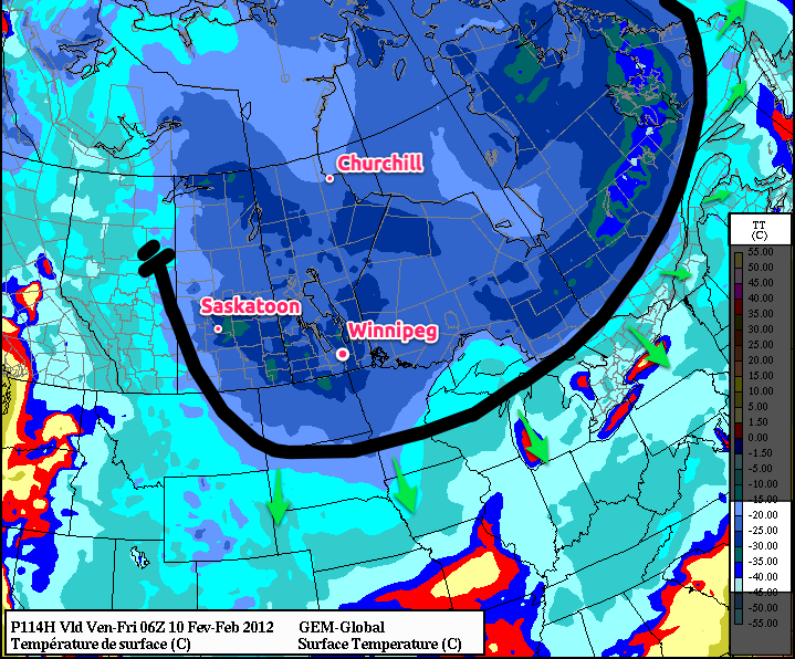
Friday Morning GEMGLB Forecast Temperatures

Forecast surface temperatures from the GEM-GLB model valid 06Z Friday, February 10th with analysis. The thick black line represents the cold front.

There is some uncertainty as to how the weather will unfold later this week. Models are hinting at the potential for another push of cold air on Thursday into Friday as another cold front sweeps through the province. Models currently differ on the exact strength of the cold push, however, as shown in the image above, some models push temperatures as low as -30°C back into Southern Manitoba. Which if it comes true, we can at least take solace that we don’t live in Northern Saskatchewan, where temperatures are forecast to be as low as -45°C!


Elsewhere in Weather News

Europe Battles Cold and Snow

This past week Europe was battered with what Canadians would call a “light snowfall” where many parts of the United-Kingdom, including London, received 10cm of snow this past weekend. The European infrastructure isn’t equipped to handle a snow storm of such magnitude which was affirmed by the fact that there were widespread airport cancellations and traffic was crawling to a standstill – some drivers were even stuck in their cars on the freeways overnight. The storm also prompted the UK Met offices to issue freezing rain warnings and cold weather alerts. The snowfall was due to a warm front pushing inland off the Atlantic Ocean and clashing with colder air that was present in the region prior, thanks to another low pressure system off to the east. The snow storm that has been wreaking havoc is forecast to lift and leave the area by Tuesday morning, leaving warmer temperatures behind and clearer conditions to come.
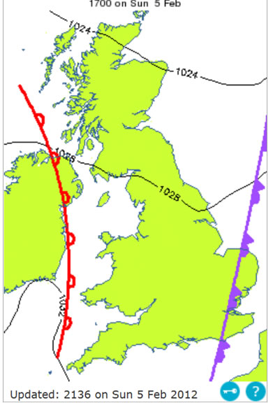
Surface Map for the UK

System’s analysis with the warm front arriving inland, clashing with the colder air to the east (occluded front). (Source: Met Office: UK)

Cold weather also affected other parts of Europe including Ukraine and Italy, with Ukraine being one of the hardest-hit of the Eastern European countries and experiencing tragedy. Kiev, Ukraine’s capital city, normally has temperatures averaging minus five Celsius for the month of February. During this cold snap however, temperatures dipped lower than minus thirty Celsius and many people have died – over 300 as of this posting. Temperatures for the next week are forecast to remain well below average, with highs only reaching the minus teens.
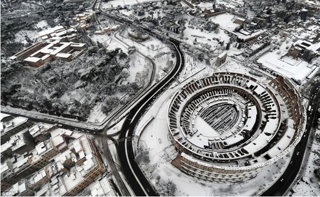
Snow in Rome

City of Rome, largest snowfall in two and a half decades. (Source: Dailymail)

In Rome, Italy, the city has received its largest snowfall in two and a half decades. The city was buried in ten to twenty centimetres, leaving the city paralyzed and people freezing in their houses, since homeowners are only allowed twelve hours of heating per day (to reduce emissions). As the low pressure system plans to stick around for a couple more days, Rome will experience well below average high temperatures of about five Celsius (average of thirteen Celsius).
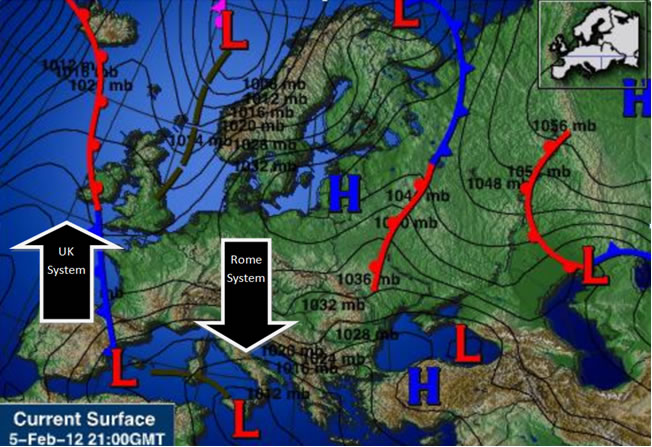
Surface Map of Europe

Europe’s system analysis, Feb 5th, showing both lows impacting Europe. (Source: Intellicast)

Elsewhere in Weather News has been provided by Matt