Elsewhere in Weather News: December 6th, 2014

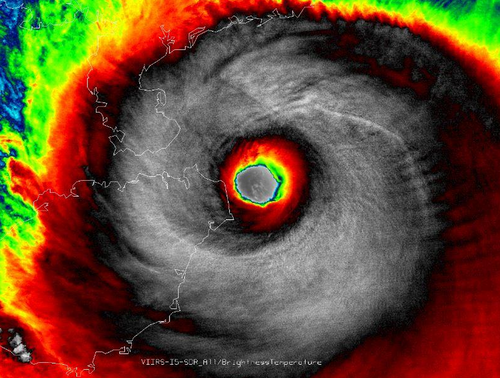
Super Typhoon Hagupit Heads towards the Philippines

The Philippines are bracing for a very strong typhoon that is expected to make landfall this weekend. Hagupit, which was formerly known as a super typhoon (with winds exceeding 240km/h) has lowered in intensity but is still considered dangerous. The slight weakening was due to an eye wall replacement that took place. As of Friday afternoon, the typhoon was located in the West Pacific and heading west towards the central islands as well as the main islands where Manila is located.

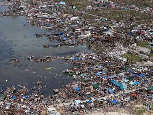
This region has seen numerous strong typhoons in the last five years including super typhoon Haiyan, which made landfall in the Philippines 13 months ago just south of where Hagupit is expected to make landfall.

Hagupit looking more ragged as it approaches the Philippines after the eye wall replacement, however the bigger eye signifies a larger wind field. (Source: NOAA)

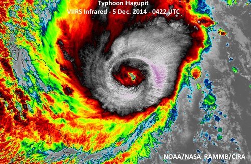
Yesterday, Hagupit had already begun lashing the islands with its outer rain bands. Evacuations were underway this past week where around 500,000 people have already been evacuated from areas most at risk including along small coastal fishing villages and in unsafe structures. The typhoon is expected to make landfall tonight near Sorsogon City, and will likely reach a high end category three or low end category four equivalent storm, bearing sustained winds of around 200km/h. Storm surges are sure to be a problem, especially along the front right quadrant of the typhoon, where surges could exceed 10 feet. Rainfall will also be of concern since Hagupit is fairly slow moving and will be able to drop copious amounts of rain. It is expected that the hardest hit areas, around where Hagupit makes landfall, could see around 500mm of rainfall.

After Hagupit emerges back over waters, the waters of the South China Sea, it is unclear as to where it will go and what its strength will be. A few of the forecast models show it holding together and continuing straight west with at least tropical storm force winds but sea-surface temperatures are not ideal for intensification in the region.

Elsewhere in Weather News: July 19th, 2014

Another Super Typhoon Spins Up in the Western Pacific

The Western Pacific Ocean has been very active in the past few weeks, churning up numerous typhoons including its most recent – super typhoon Rammasun. Rammasun made landfall at least twice; once in the Philippines and China, respectively, during its trek across the Western Pacific.

The first landfall occurred southeast of Manila, Philippines, where it brought with it winds of 185km/h. Many precautions were taken ahead of this storm in the Philippines as it was the first typhoon to hit the country since super typhoon Haiyan. Over 500,000 people decided to ride out the storm in evacuation centres and plenty of warning (3 days) was given to residents before the typhoon made landfall. Despite the warnings, many homes could not be saved – as many as 7,000 as reported by authorities. Unfortunately 38 people died due to the typhoon in the Philippines.

After making landfall in the Philippines, Rammasun quickly strengthened with help from the very warm sea surface temperatures (SSTs) that approached 30°C in the South China Sea. With these warm SSTs conditions were primed for the storm to reorganize. Rammasun quickly developed a well-defined eye and became a super typhoon (category 4) as it approached China for a second landfall. The typhoon made landfall on Friday morning with sustained winds of 250km/h gusting to 280km/h on one of China’s southern provinces; Hainan. All modes of damage were possible with a storm of this intensity; including flooding rains, landslides and severe storm surge. It is still unclear how the region is doing in the aftermath of the storm as of Friday night. A report of 178mm of rain in the coastal city of Haikou (pop. 900,000) in 6 hours on Friday combined with expected storm surges of 20 feet in the general area made for big flooding/landslide concerns. Rammasun is expected make a turn for China’s mainland and die off this weekend, but not before bringing widespread torrential rains to the region.

IR image of Rammasun just before it made its second landfall. (Source: NASA/NOAA)

More tropical storms are expected to spin up this week with possibilities in both the Atlantic and Western Pacific as depicted by some models. The strength or paths of these are uncertain.

Elsewhere in Weather News: January 25th, 2014

Flooding Problems Return to Philippines

It has been just over two months since typhoon Haiyan ravaged the Philippines and yet another tropical system has swept across the Philippines this past week to cause problems. Agaton, which was only rated a tropical depression bearing winds of 55km/h, was very slow-moving at only 5km/h towards the west. This was mainly due to high pressure to its west-northwest blocking its movement. In turn, severe flooding and landslides over the mountainous terrain was possible as the storm churned over land and was able to drop large amounts of rain at the same time.


The Manila Observatory posted a compilation of rainfall amounts between January 10th to 19th in the Mindanao region. (Source: Manila Observatory)
The Manila Observatory posted a compilation of rainfall amounts between January 10th to 19th in the Mindanao region. Click on image to enlarge. (Source: Manila Observatory)

The bulk of the rain passed south of the areas ravaged by Haiyan, affecting the provinces of Suriago, Agusan, Leyte and various others. Rainfall rates between 10-50mm/h were observed on radar but in the strongest convective bands reached up to 140mm/h. Total accumulations for the week reached over 1200mm (1.2m) in the hardest hit areas of northern Mindanao where the average January rainfall is 370mm! Unfortunately with this extreme rainfall came flooding and landslides which contributed to 42 deaths and has displaced 129,000 people.


Total rainfall for Philippines between Jan. 10th and 17th, while Agaton was affecting the region (NASA-TRIMM image). (Source: NASA)

After making landfall Agaton slowly weakened and was downgraded to a low pressure system. This weekend it is no longer a threat to the Philippines.

Elsewhere in Weather News: November 16th, 2013

Typhoon Haiyan Final Update, Moderate Risk for Midwest US

It’s been over a week since super typhoon Haiyan made landfall in the Philippines and a second landfall over Vietnam. The impacts in the Philippines and Vietnam are just now starting to surface and the reports coming out of the countries are not good.

Vietnam had had quite a bit of time to prepare for the storm and 70,000 people were evacuated from low lying areas. These preventive measures surely saved lives in the flood-prone and landslide-prone areas of Vietnam, but unfortunately five people still lost their lives in the floods. Storm surge was not as big an issue as it was for the Philippines as Haiyan had significantly weakened by the time it made landfall in Vietnam.

For the Philippines the death toll continues to climb (3,600 people) as the cleanup continues. One neighbourhood of Tacloban City of about 10,000 people has been literally washed off the map according to the city’s mayor, with no houses left. An early estimate for the damage is 12-15 billion dollars.


Aerial picture of Guiuan, one of the hardest hit areas, to the east of Tacloban. (Source: National Post)

Unfortunately, this past week another tropical disturbance made its way to Vietnam and brought anywhere from 250mm to 500mm in the central part this past week. To the already saturated grounds, this was enough to cause some more flash flooding. As of Friday night’s reports 3,500 houses had been lost and power was out for various cities in central Vietnam. In total, 17 people had lost their lives from this event.

In other weather news this week, a negatively tilted trough will be making its way across the US Midwest and has the chance to produce some severe weather on Sunday. SPC has outlined a 45% hatched area, moderate risk stretching up to Southern Ontario. Though CAPE is limited, shear is quite impressive, thus, severe winds will be the main threat with this event. If the sun does get a chance to heat up, brief spin-ups could become a threat with the low cloud bases. It is not all that common to see severe events of this magnitude stretching up to Southern Ontario in the middle of November.


45% hatched area for the US Midwest, the main threat will be wind damage. (Source: SPC)