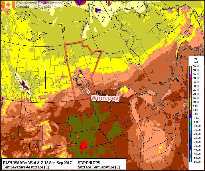
Winnipeg will see the weather slide from September Summer™ to seasonal to cool and rainy over the next few days as a developing storm system in the Northern Plains gets set to bring a major pattern shift to southern Manitoba.
Today will continue the September Summer™ for Winnipeg and the Red River Valley as daytime highs climb well above-seasonal into the mid-20s under nothing but sunshine. Winds will be fairly light today too at just 15-20 km/h, making for a gorgeous day. Some cloud cover will move through tonight as temperatures dip to a low near 13°C.
Warmer than seasonal daytime highs will continue for another day across southern Manitoba
Thursday will see the beginning of a major pattern change as a major low pressure system gradually organizes through the northern plains of the United States. As it does so, a northeast wind to 20-30 km/h will begin tapping cooler air from the central Prairies, returning near-seasonal temperatures back to Winnipeg and the Red River Valley. Skies will be mixed with increasing cloudiness overnight.
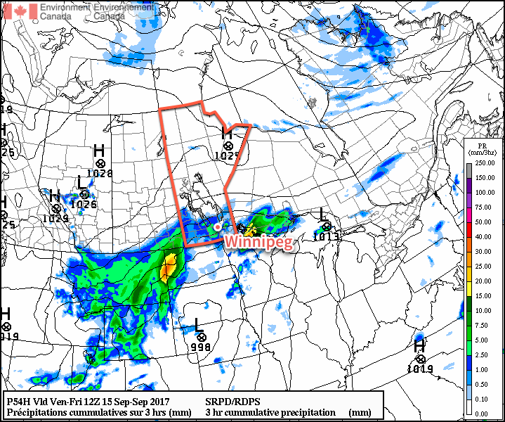
Friday’s dominant weather feature will be a trough of low pressure developing across central North Dakota into southeastern Manitoba in response to a low pressure system tracking into Nebraska out of Wyoming. This trough line will support the development of a large area of rain that will spread northeastwards from western North Dakota along the trough, likely arcing through southwest Manitoba and across the Red River Valley into the Whiteshell.
Rain will spread northeastwards out of Montana and western North Dakota on Friday morning
This feature has all indications that it will be a prolonged rainfall event, with rain beginning Friday morning and continuing into Saturday morning. Total rain will be variable and dependant on whether or not any embedded convection develops, but general amounts of 20-30 mm look quite likely. With all the rain, temperatures will be quite cool with highs well below-seasonal in the low teens.
Long Range
Unsettled weather will continue on Saturday with improvement on Sunday, but the chance for more rain will return on Sunday night into Monday morning. Temperatures will remain below-seasonal through the weekend.
Into next week, temperatures will return to near-seasonal values, but it looks like there will be multiple chances for rain as several disturbances cross the Prairies.
Winnipeg’s seasonal daytime high is currently 18°C while the seasonal overnight low is 6.
Temperatures will be well below-normal today as Winnipeg and the Red River Valley remain entrenched under a cool northeasterly flow behind yesterday’s low that moved through the region. Temperatures will rebound quickly, though, with well above-normal temperatures return for the end of the work week.
Today will see high temperatures some 10°C below typical seasonal as cool, cloudy weather hangs over the Red River Valley as northeasterly winds tap cooler air underneath a cold upper-level low crossing over the region. Skies will remain cloudy much of the day — there’s a slight chance we might see some sunny breaks late this afternoon — and there will be a chance for some light rain or drizzle, particularly in the morning hours. Temperatures will reach a high of only around 16°C1 with winds out of the northeast at 15-25 km/h.
Skies will begin to clear tonight as temperatures dip to a low near 11°C with light winds.
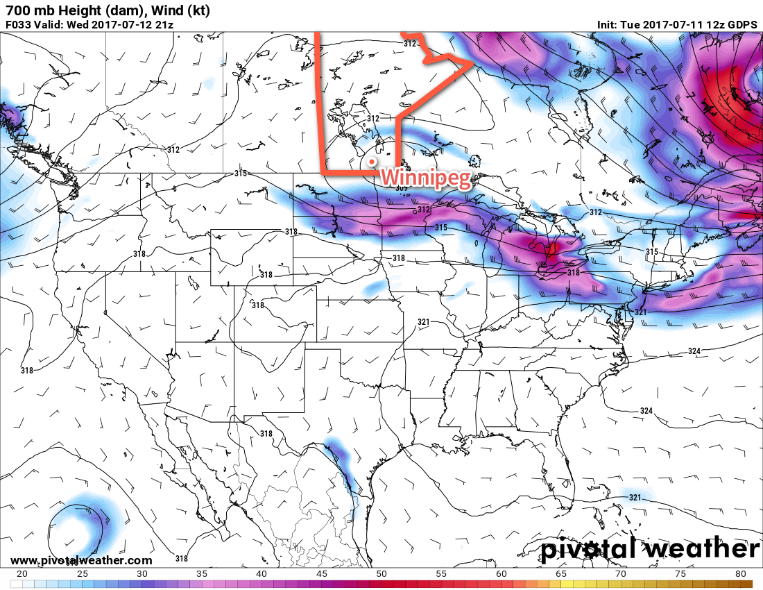
A cold low, shown here with closed height contours at the 700mb level, will move across southern Manitoba on Wednesday, keeping skies cloudy and temperatures cool.
Thursday will be a much nicer day as the remaining cloud cover clears out and temperatures climb to a high near 23°C under light winds. There may be some scattered clouds in the afternoon, but nothing that will spoil the sunshine. Expect clear skies on Thursday night as temperatures drop to a low near 13°C.
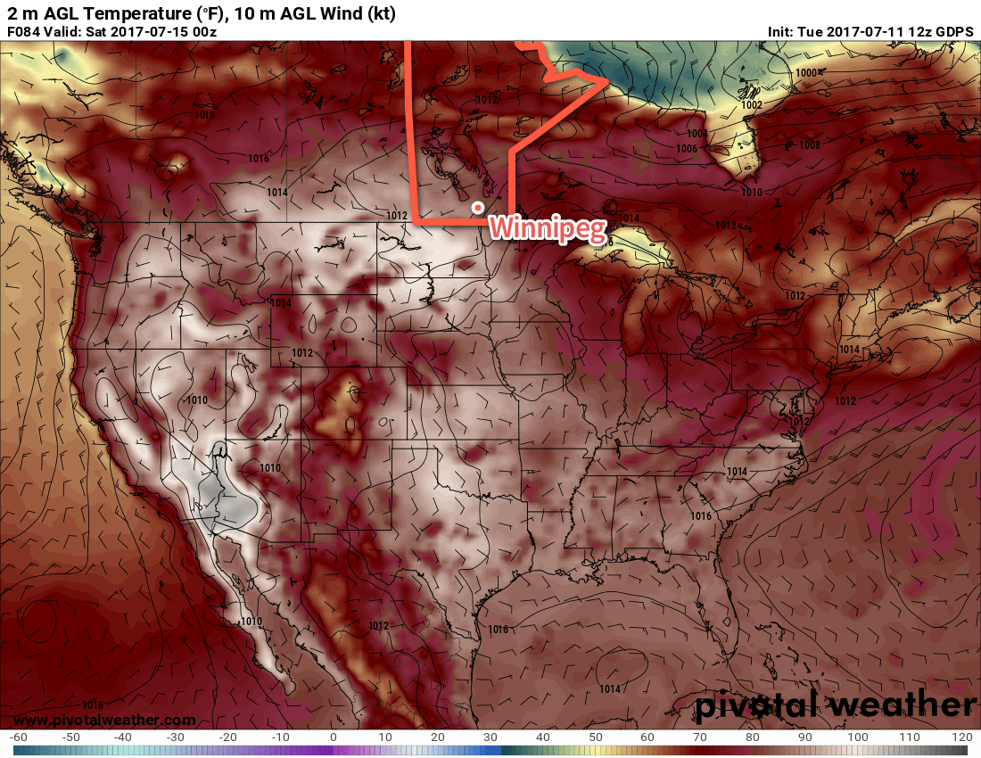
On Friday, the upper-level ridge that brought scorching hot weather to B.C. and the western Prairies last week begins building back into the region. Under sunny skies, temperatures in the Red River Valley will climb into the lower 30’s. Areas in the southwest corner of the province will be even hotter, with high temperatures climbing into the mid- to upper-thirties. Southerly winds at 20-30 km/h will be in place as a low pressure system slumps towards the region from the northwest. These winds will draw humid conditions northwards; by the end of Friday dew point values will climb into the low 20’s, making it feel positively muggy out there.
Very warm temperatures will build across the entirety of the Southern Prairies on Friday with highs in the 30’s.
Friday night will continue to be warm with lows dropping only to around 18°C.
Long Range
Northerly winds will move into the region on Saturday, flushing the humidity southwards and making for more comfortable conditions. Daytime highs will still remain in the upper 20’s or low 30’s throughout the weekend under mainly sunny skies. With the warm air still in place, overnight lows will still be quite warm, likely bottoming out in the upper teens.
The hot weather continues next week, but there are signs that there may be some unsettled weather to begin the week before things settle down again. No significant widespread rainfall is expected in the next week.
Winnipeg’s seasonal daytime high is currently 26°C while the seasonal overnight low is 13°C.
Although if more clearing were to develop than expected, temperatures would quickly reach closer to 18 or 19°C. ↩
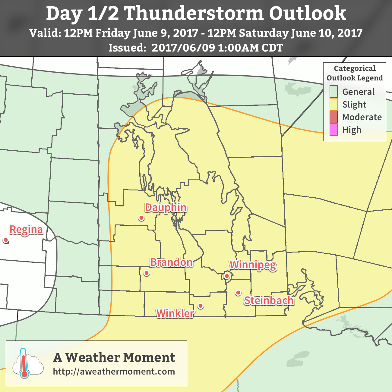
A complex low pressure system will bring several chances for thunderstorms to Winnipeg & the Red River Valley today and tonight into Saturday morning, some of which may be severe. All the unsettled weather will clear out on Saturday afternoon, leaving us with a seasonably mild and dry weekend.
The risk of thunderstorms returns to Winnipeg today as an approaching warm front moves into the region. As it advances eastwards, leftover cloud cover from overnight thunderstorms in Saskatchewan will spread into the Red River Valley. Before we get into the thunderstorm details, today’s high in Winnipeg will be a balmy 27°C with dew points climbing up to the 16-17°C range, making it feel a bit humid in the afternoon. Winds will be out of the south-southeast at about 20-30 km/h. Expect a low tonight near 18°C. Now, onto the thunderstorm details!
The first potential thunderstorm threat is for this afternoon, and will be focused primarily over southwestern Manitoba.
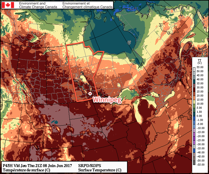
Moisture: Surface dewpoints will climb into the 15-17°C range ahead of the surface trough moving into the region. This moisture will be relatively deep, dropping only to around 13°C at 850mb.
Instability: MLCAPE values will climb to 1000-1500 J/kg of CAPE through the afternoon, although capping may be an issue depending on the timing of the 700mb thermal ridge passage.
Shear: Shear is fairly good with veering profiles and 45-50 kt of bulk shear. Low-level shear is relatively unidirectional with moderate speed shear.
Trigger: Low centre with trough line extending northwards will provide focus for low-level convergence. Additional, the triple point of a frontal wave tracking along the U.S./Canada border will also provide more focus and convergence.
The main uncertainties are tied to how quickly warmer air at 700mb1 can exit area. While it’s in place, it will likely prevent the development of thunderstorms until the evening. Should thunderstorms develop, the primary threats would be large hail and strong winds. The storms should be moving quickly enough that the threat for localized flooding due to rain is minimized, and higher cloud bases coupled with relatively small amounts of low-level wind shear will also reduce the tornado threat. If these thunderstorms develop, they will track eastwards into the Red River Valley in the early evening and make their way through.
The second thunderstorm threat will develop this evening and will impact much of southern Manitoba. Another disturbance will push into the region and initiate thunderstorms.
Moisture: The low-level jet will be supplying air with dew points near 16-17°C, providing ample moisture for thunderstorm development.
Instability: MUCAPE values will hover near 1000-1500 J/kg, enough energy to strong to severe thunderstorms.
Shear: Will be excellent; a very potent low-level jet will develop, strengthening to 50kt by 03Z. 500mb winds will be out of the west to southwest at 45-50 kt. This shear will be very supportive of thunderstorm development.
Trigger: Shortwave and associated frontal wave will be trigger for thunderstorm development.
Even now, there’s significant uncertainty with this afternoon’s convection. That said, it seems likely that thunderstorms will likely develop over portions of southwest Manitoba near 6-7PM and then undergo rapid upscale growth and develop into a line that tears eastwards across the Red River Valley; the primary threats associated with these storms will be large hail and damaging winds. Significantly elevated precipitable water values also suggest very intense downpours are likely as well.
AWM Thunderstorm Outlook valid 12PM Friday June 9 – 12PM Saturday June 10, 2017
Saturday will bring some more morning showers or thunderstorms, then breezy westerly winds of 30 gusting 50 km/h will usher in drier air in the afternoon as the clouds break up and clear out. Temperatures will climb up to a high near 23°C. Expect a low near 13°C under mainly clear skies on Saturday night.
Sunday will bring mainly sunny skies to Winnipeg with winds strengthening out of the southwest to around 30-40 km/h. Temperatures will climb to a high near 25°C. Winds will taper off Sunday evening as temperatures dip to a low near 15°C.
Long Range
Next week becomes quite uncertain as a major low pressure system develops in the Northern Plains of the United States and then slowly meanders northwards. As we move into summer, these systems will increasingly be driven by thunderstorms, which carry an inherent level of uncertainty, especially in the long range as how the various rounds of thunderstorm activity develop can impact the overall development of the low pressure system. That said, conditions will turn unsettled next week with near-seasonal to slightly above-seasonal temperatures.
Winnipeg’s seasonal daytime high is currently 23°C while the seasonal overnight low is 10°C.
An Additional Note
This will be the last forecast we issue here at A Weather Moment for the next while. We’ll be taking a bit of a vacation and won’t have our regular forecast posts on Monday June 12th or Wednesday June 14th. We suggest you check Environment Canada’s forecasts while we’re away!
While today will bring cooler highs in the low 20’s to the Red River Valley, the break from the heat will be short-lived. High temperatures will quickly rebound back into the upper 20’s for both Thursday and Friday alongside plenty of sunshine!
Mostly cloudy skies will persist over the Red River Valley today as an upper-level trough moves through the region. The cloudier skies will temperatures lower than the 29-30°C seen over the last couple days; today will reach a high of just 22°C. Winds will be out of the north to northwest at around 15-25 km/h. Skies will clear out overnight as temperatures head to a low near 13°C.
Thursday will be a beautiful day as high pressure moves into the region and brings partly cloudy skies and much warmer temperatures as highs through the Red River Valley rebound to 27-28°C. Winds will be out of the south at 20-30 km/h and humidity levels will be comfortable.
Temperatures will rebound into the upper 20’s across the Red River Valley on Thursday.
Friday will start off with sunshine, but clouds will move in through the day as a low pressure system approaches from the west. Winnipeg may see a chance of shower in the afternoon. Temperatures will remain warm with highs near 28°C, and winds will strengthen out of the south to around 30-40 km/h. The chance for rain will continue on Friday night as temperatures drop to around 18°C.
Long Range
There’s quite a bit of uncertainty for the weekend, but the general idea is that Winnipeg may see a few bouts of showers or thunderstorms as a series of low pressure systems move through. The beginning of next week also looks unsettled, with a slow-moving low pressure system forecast to impact the region, bringing multiple chances for rain across several days.
Winnipeg’s seasonal daytime high is currently 23°C while the seasonal overnight low is 10°C.