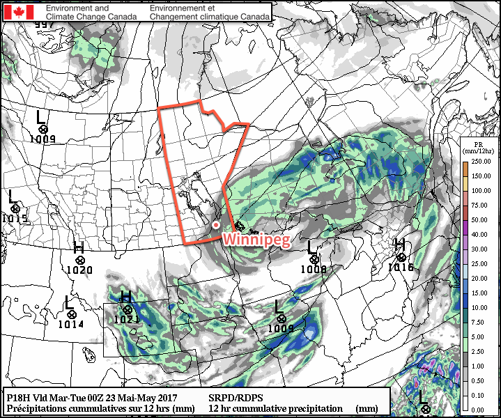
The reprieve from yesterday’s 10-20mm of rain that fell across the Red River Valley will be short-lived as another disturbance will move through the region today and bring more wet weather. Fortunately, things will improve quickly with clouds clearing out for Tuesday and Wednesday alongside a rebound to seasonal temperatures.
It will be another cool one in Winnipeg today with mainly cloudy skies and intermittent showers as a disturbance slumps southwards from the Interlake, bringing another couple millimetres of rain to the region. Temperatures will top out at just 12°C today, kept down by the cooler air mass and brisk northerly winds that will develop a bit later this morning to around 30 gusting 50 km/h. The rainy weather will finally taper off late this afternoon into the early evening, and Winnipeg will be left with cloudy skies and northerly winds of 15 to 20 km/h as temperatures dip to a low near 8°C.
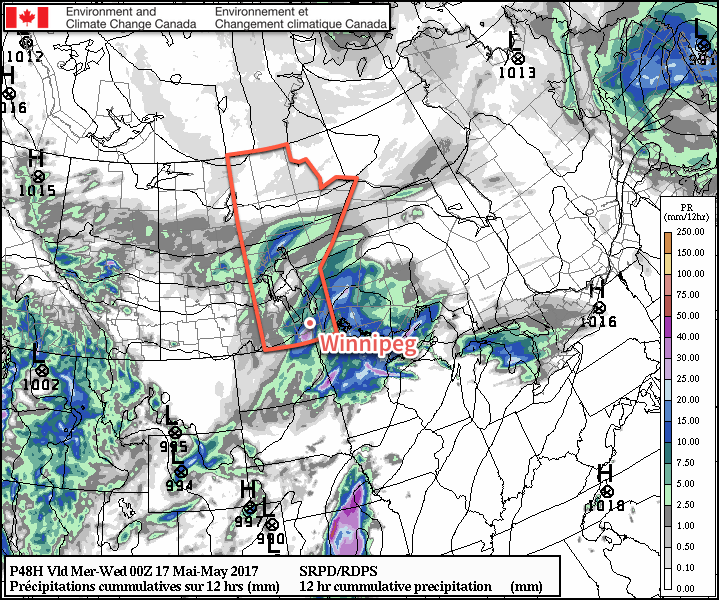
Light rainfall accumulations are expected across portions of Southern Manitoba today.
Tuesday will be a much nicer day with skies clearing in the morning and then temperatures climbing to a high near 19°C. Winds will remain out of the north to northeast at 15-20 km/h. Expect a low near 9°C on Tuesday night under clear skies with light winds.
Wednesday will bring more pleasant weather to the city with mainly sunny skies and a high near 21°C. Winds will increase out of the south from calm to around 30 km/h through the day.
Long Range
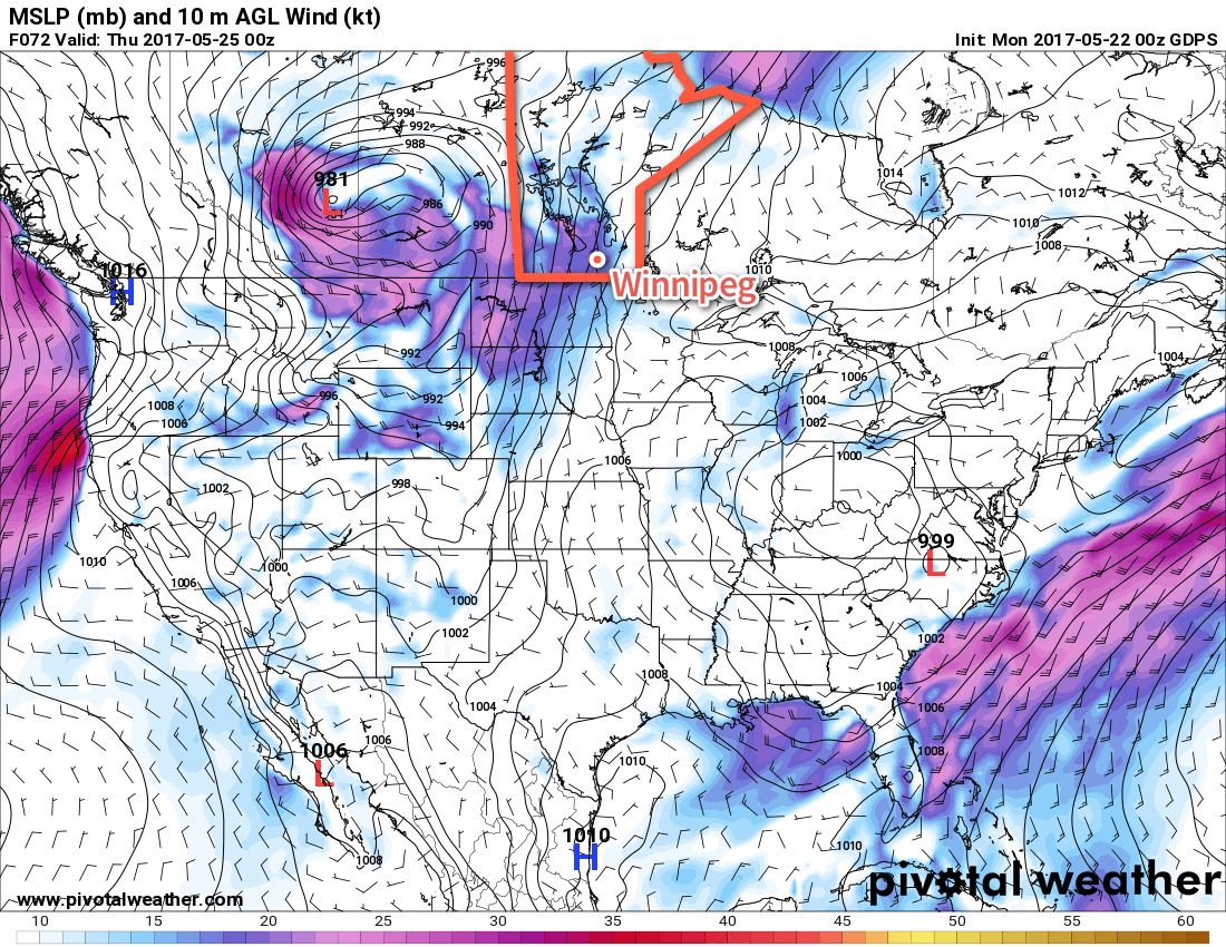
Conditions will turn more unsettled through the second half of the week as a major storm develops over Alberta and track eastwards.
A very potent low pressure system will develop in Alberta on Wednesday, bringing very strong and potentially damaging winds with it. This system will track eastwards and weaken through the second half of the week.
As it does so, Winnipeg will see a few chances for precipitation Thursday through Saturday, but it really seems like we’ll avoid the worst of this system. We’ll be keeping an eye on it as it develops and begins to push towards the region.
Winnipeg’s seasonal daytime high is currently 21°C while the seasonal overnight low is 7°C.
After a couple windy and seasonably cool days, temperatures are set to warm slightly towards near-seasonal values. Unfortunately, the sun will end up rather elusive through the weekend as a low pressure system lifting northwards out of Texas pushes towards Manitoba and spreads cloud into the region.
Despite a rather cool start to the morning, temperatures will rebound nicely today as the ridge of high pressure responsible for the cool, windy weather the past few days begins pushing off to the east. With light winds, Winnipeg will warm up to a high near 18 or 19°C under plenty of sunshine for much of the day. By mid- to late-afternoon, cloud cover will begin to push into the region from the south, spread northwards from a low pressure system heading towards Minnesota from Texas.
Winds will remain light on Friday night as temperatures drop to a low near 7°C under mixed to mostly cloudy skies.
Saturday will bring mostly cloudy skies to Winnipeg and the Red River Valley with temperatures climbing to a high near 18°C. Winds will remain light once again, making for a relatively pleasant day despite the lack of sunshine. Temperatures drop back down to around 8°C on Saturday night under cloudy skies.
Milder weather will push back into Manitoba for Friday and Saturday
Sunday will finally bring southern Manitoba under the influence of the low pressure system from Texas as pushes northeastwards through Minnesota. This system has a high chance of bringing some rain to southeastern Manitoba, but further west in the Red River Valley there exists a bit more uncertainty.
The bulk of the precipitation associated with this system will fall in Ontario, however it’s quite likely there will be a band of rain wrapping around the back-side of the low that impacts southeastern Manitoba. The biggest question is how far west that rain will be able to wrap around. The best indications at the moment is that the Whiteshell, Sprague, and areas primarily south of Steinbach and east of the Red River will see some rain, with areas further west in the Red River Valley having just a chance of showers. For the areas that do see rain, amounts should be light, with just around 2-4mm expected.
Some rain is expected to wrap-around a low pressure system into southeastern Manitoba on Sunday
Otherwise, temperatures will rise to a high near 17°C in Winnipeg while winds increase out of the north to 20-30 km/h. The chance for rain will taper off through the afternoon, then Winnipeg will head towards an overnight low of 8°C on Sunday night under mixed to cloudy skies.
Long Range
Much of the same is expected into the first half of next week. Monday will likely continue to bring fairly cloudy conditions with a very slight chance of a shower as temperatures climb to a high in the 15-20°C range. Tuesday into Wednesday should see things settle down with near-seasonal temperatures, but then the pattern may switch to slightly more unsettled, bringing in some chances for precipitation through the latter half of the week into the weekend.
Winnipeg’s seasonal daytime high is currently 20°C while the seasonal overnight low is 6°C.
Winnipeg managed to eke out a fairly pleasant Sunday with a cloudy morning giving way to sunny breaks in the afternoon as temperatures climbed up into the low 20’s. Showers that had the potential to impact the city ended up splitting as they entered the Red River Valley; one area headed to the north and across the Interlake while a second area of showers moved through North Dakota. Another chance for rain is on the way, though, with a low pressure system forecast to move through the region on Tuesday.
Attention now turns towards a developing low pressure system in Wyoming that will organize through the day today, strengthen tonight, and then move through the region on Tuesday.
Today will bring increasing cloud cover, particularly through the afternoon, but otherwise will be a pleasant day with a high near 22°C and relatively light winds. Tonight will bring mixed to cloudy skies with a low near 12°C as the low pressure system builds into North Dakota.
Tuesday’s forecast has a lot of room for error, but we’ll take a stab at broad generalities here. The short version: expect cloudy skies with a very good chance of seeing rain and/or thunderstorms beginning mid- to late-morning and tapering off in the late afternoon or early evening. Winds will pick up out of the north to northwest through the day to around 40 km/h as the low pressure centre moves through the Lake of the Woods region. Temperatures will top out near 15 or 16°C and drop to a low near 7°C on Wednesday night.
Some forecasts hint as much as 25-40*mm* of rain in the Red River Valley on Tuesday.
The long version: everything begins on Monday night as an area of thunderstorms develops across western North Dakota on the northern side of the surface low. These storms should expand in coverage through the night, spreading east-northeastwards along a warm front draped southwest-to-northeast across the state. This area of convective rainfall will spread into southwestern Manitoba late Monday night into Tuesday morning, then spread eastwards into the Red River Valley. At this point, there may be thunderstorms still embedded in the area of rainfall, but that risk will diminish through the morning. The rain will move eastwards through the day, then taper off in the late afternoon. With the convective nature of the rainfall, accumulations may end up being highly variable, but overall it seems like 10-20mm is quite likely, with higher amounts possible on a more localized level.
Now this is all fairly prone to error; primarily, a strong low-level jet is expected to develop across South Dakota along the eastern quadrant of the low, which may end up being a foci for thunderstorm development and rob this system of moisture that would have travelled further northwest or pull this system eastwards slightly faster, possibly causing the rain to pass to the southeast of the Red River Valley.
On Wednesday, the winds will remain gusty out of the north with temperatures climbing to a high, optimistically, near 11°C. Skies will start off fairly cloudy, but gradually break up a bit for the afternoon. Significant clearing will likely hold off until the overnight period as temperatures drop to a low near 2°C.
The remainder of the week looks dry with highs slightly below-seasonal and a fair amount of sunshine.
Winnipeg’s seasonal daytime high is currently 20°C while the seasonal overnight low is 5°C.
A developing winter storm will bring moderate-to-heavy snowfall to southern Manitoba beginning early Monday morning. The storm system will primarily affect the Red River Valley and areas east, bringing a fair amount of wet, heavy snow to the region.
Monday’s main story will the snow that moves across the region, supported by a developing low pressure system lifting northeastwards through the Dakotas. The area of snow will rapidly develop overnight, first across western North Dakota, then expanding quickly northwards.
The snow will fall throughout much of the day in the Red River Valley, and into the evening over southeastern portions of the province. It will fall mainly as snow, except for the far southeastern portion of the province—particularly in the Sprague area—where it may become mixed with ice pellets or rain as warmer air wraps in just north of the low.
AWM Snowfall Outlook for Monday April 24, 2017
By the time the snow tapers off this evening much of the south-central and southeastern portion of the province will see between 5-10 cm of snow. The Whiteshell region will likely see 10-15 cm of snow.
Potential Forecast Issues: There are a few potential sticky spots for the forecast. The first hinges on temperatures, which are largely expected to be hovering near the freezing mark. If things end up a bit warmer, snowfall totals will be reduced, either due to lower snow-to-liquid ratios and increased melting/compaction of the snow, or via greater mixing of rain. If temperatures end up dropping a bit cooler than expected, snowfall amounts will bump up a bit, but the greatest impact would be in Sprague, which would go from “near 10 cm with mixed precipitation” to “10-20 cm of heavy snow.”
The most likely snowfall amount for Winnipeg is likely in the 7-10 cm range, with a very small chance of creeping up to 11 or 12 cm. While this may seem like a pretty notable snow, it’s not very significant in the grand scheme of things and doesn’t even register on the top 10 largest daily snowfalls after April 15th:
Top 10 Largest Daily Snowfalls After April 15 (Winnipeg 1872-2016)
Winds will pick up out of the northeast early Monday to around 30 km/h and remain at that strength for quite a while, gradually shifting to the north by Monday evening and then persisting through Tuesday until tapering off on Tuesday night. Temperatures will drop to a low near -3°C on Monday night, climb to a cloudy high near +3°C on Tuesday and then drop back to a low near -6°C under mixed skies on Tuesday night.
The cloudy skies and cooler temperatures will slow the snow melt over the region, and as a result the snow will likely stick around longer than Friday’s snowfall did. However, the sun should poke a bit on Wednesday which, when combined with a slightly warmer high near 4°C, should be enough to melt the snow.
We’ll be keeping an eye on new runs of weather models as they roll in later tonight and update this post if there’s a significant shift in the snowfall forecast.
Long Range
Cooler-than-normal temperatures will persist through the remainder of the week with daytime highs of 5-9°C remaining below the seasonal average of 14-15°C.
Winnipeg may see some more rain or snow on Thursday as a large low pressure system lifts into Northern Ontario and may spread precipitation westwards into Manitoba; this seems relatively unlikely, but it’s worth being aware of as an outside possibility.
Things should settle down for the weekend with a return towards seasonal temperatures, however long range models show the potential for another system Sunday night into Monday that could bring more rain and snow into the region.
Winnipeg’s seasonal daytime high is currently 14°C while the seasonal overnight low is 1°C.