Slight Chance of Showers Saturday Evening

A system tracking across the Rockies into Alberta will slide quickly across the Prairies, brining increasing cloudiness to Winnipeg and the RRV Saturday afternoon with a slight chance of showers in the evening. For more info, read on!

GEM-REG 3HR. QPF
12Z 21 October GEM-REG 3 hour precipitation accumulation valid at 00Z Sunday (Saturday Evening)

Overnight a low pressure system will track across the Central Prairies towards Manitoba with a developing N-S trough intensifying as it moves eastwards. As it enters The Pas and Norway House areas on Saturday, Winnipeg and the RRV will see increasing clouds and a strengthening southerly wind to 30-40 km/h. As the trough swings through Winnipeg in the late afternoon and early evening, we’ll see a slight chance of a shower or two. The bulk of the precipitation should stay north of the city, closer to the low, where there is more significant lift. All models bring the edge of the rain close to Winnipeg, though, so it certainly isn’t out of the question for us to end up getting 2-4 mm out of an hour or two of rain. It seems most likely, though, that late afternoon and the evening will be overcast with a scattered shower or two.

After this system passes through, we’ll enter a stagnant pattern for a couple days with daytime highs just below 10°C and overnight lows slightly below 0°C.

Ensemble 500mb Theta-E
Ensemble Mean 500mb θe

The next chance for significant weather looks to be next Tuesday night / Wednesday morning as a rather sharp 500mb cold trough swings across the province. This will present us with a slight chance of flurries overnight, but shouldn’t amount to too much. More on that next week.

Have a great weekend and enjoy these crisp fall days!

Significant Rainfalls On The Way for Tuesday

A low-pressure system approaching Manitoba will rapidly develop this evening as it enters the province, bringing one of the most substantial widespread rainfalls of the last several months. The largest amounts will lie along a narrow axis called the deformation zone which makes these events hard to predict: a slight change in the track of the low can cause shifts in the placement of the deformation zone. So where will Winnipeg lie? What can other areas of the Red River Valley expect? Click through to find out!

12hr. QPF GEM-REG
12hr. Rainfall from the GEM Regional Model, valid 00Z Wednesday Evening

This system is slowly built into Southern Alberta through the night last night, and is now beginning to quickly move eastwards across the Prairies. Currently, the system is fairly weak, giving only light showers to many areas across Southern SK/AB, however a shortwave ejecting onto the Prairies from the Canadian Rockies will slidealong the US/Canada border this evening and overnight and will be able to tap into warmer air aloft over the Eastern Prairies and a pool of extremely cool, Arctic air over the Northwestern Prairies.

The combination of a powerful shortwave with access to these two air masses will result in a rapidly deepening low pressure system. Currently, the low sits just east of Regina and has a central pressure of about 100.8kPa. By mid-morning Tuesday, the low will sit over the Southern Red River Valley with a central pressure of 99.5kPa, which is a significant drop in pressure over 12-18 hours.

Rain will push into SW Manitoba by this evening, with a few scattered showers across the Red River Valley before midnight. Rain will intensify and build across the RRV into SE Manitoba overnight as the system really starts tapping into some of the cooler air across the Northern Prairies. The deformation zone will become quite apparent by tomorrow morning, which will make the precipitation forecasts easier, but right now it’s looking like it will set up just over or the southeast of Winnipeg.

So! What does this all mean?

Rain will push into Winnipeg and areas south overnight and be quite intense at times. Widespread amounts through these areas will likely be 5-10mm overnight, with the chance of some higher amounts over the Western Escarpment. Tomorrow will be quite an active weather day, with continuous rain for much of the RRV and strong winds with gusts as high as 70-80km/h from the north. These strong winds will likely cause some localized erosion on the lee beaches of the lakes which are still dealing with high water levels.

Areas south of Winnipeg will see an additional 15-25mm of rain tomorrow with few areas getting as much as 30mm, as will the Whiteshell. Winnipeg itself, however, will be trickier. If the deformation zone sets up to the southeast of us, we’ll likely only get perhaps 5-10mm. If we end up under it, or it moves to our NW, we could see substantial amounts of rain. Right now, the likely scenario is 10-15mm, with the potential for amounts as high as 30mm.

The system will clear out by Wednesday and we’ll be left with daytime highs in the mid to high teens for Wed/Thursday as we sit in cooler air behind the cold front associated with the system. By the end of the week, another upper ridge begins to build into the Prairies which will push sunshine and warm temperatures back into Southern Manitoba. Currently, it looks like we’ll see highs in the mid-20’s by week’s end.

So enjoy that (most of) you’ll be at work tomorrow during our kind of miserable day, and we’ll all enjoy the sunshine and warm temperatures in another taste of summer this weekend!

Dry Streak Finally Over

In a new post over at Rob’s Blog, Rob describes exactly how dry it has been this summer in Winnipeg. I recommend you head over and read it, but the highlights are:

  • This summer the CYWG airport site recorded 93.0mm of rain from June to August.
    • This value is over 140mm below average
  • This year was the driest summer since 2006, when only 91.5mm of rain was recorded.
  • Southwest Manitoba and the Southern RRV experienced near-normal amounts of rain while the Northern RRV and Eastern MB experienced the dry conditions this summer.
  • This summer was the 5th driest summer on record.

Be sure to head over to Rob’s Blog to see the whole post and some more details on this summer compared to climatology. All in all, if you enjoy the sun, this summer in Winnipeg has been the summer for you!

The hot and dry weather came to an abrupt end early Thursday morning when Winnipeg received ~20mm of rain as a large complex of thunderstorms rolled through Southern Manitoba, giving large amounts of rain and winds as high as 110km/h over portions of extreme Southern MB. After a day of sun with much cooler temperatures, Winnipeg is set to likely receive another round of showers tonight. Read on to find out what’s in store!

18:15Z Water Vapor Image
Water Vapor (7µm) Image of Canada from 2:15PM CDT. L – Low; Blue Line – Cold Front; Red Line – Warm Front; Green Arrows – Expected Track of Low

A moderately strong upper low is tracking southeastwards across the Prairies today and will slump to the International Border near Melita by late this evening and then slide east along the border, crossing over the RRV overnight. A frontal wave associated with this system will mirror its parent’s motion and slide along the same track ahead of the system, arriving at the western edge of the RRV by early-to-mid evening.

6 Hour QPF from GEM-REG 12Z Model Run valid at 06Z 03 Sept. 2011
6 Hour QPF from GEM-REG 12Z Model Run valid at 06Z 03 Sept. 2011 (1AM CDT)

Showers and isolated thunderstorms will develop along the warm front early this evening, pushing into the RRV around midnight. The rain will push across the RRV and through Winnipeg overnight. Most of the RRV will see only 2-4mm of rain, and there is no risk of severe thunderstorms. Perhaps a bigger story with this system is rainfall totals in areas north of the the low track.

24 Hour QPF from GEM-REG 12Z Model Run valid at 12Z 03 Sept. 2011
24 Hour Total QPF from GEM-REG 12Z Model Run valid at 12Z 03 Sept. 2011

The above picture shows the total amount of rain that is expected to fall from Friday 7 A.M. CDT to Saturday 7 A.M. CDT. Over 40mm of rain are expected to fall across portions of Eastern Saskatchewan, across the Parkland areas of Manitoba including Dapuhin and Minneodsa, through the Interlake and into Northwestern Ontario.


For Saturday, Winnipeg and the rest of the RRV will see the chance of showers as the cold front pushes through in the morning. By early afternoon things will begin to stabilize with the passage of the front, and most of the RRV will see winds of 30-40km/h behind the cold front with gusts up to 60km/h.


Chart of 500mb Heights and Temperatures valid for the evening of Wed. Sept. 7

Things look calm in the long-term, as after this system the upper ridge begins to redevelop aloft. It will continue to intensify through the next week, bringing sunny skies and the return of warmer weather. We should see relatively light winds most of next week with daytime highs in the mid-20’s. Summer isn’t over yet!

Powerful Thunderstorm Rips Through Winnipeg; What’s Next?

Winnipeg Lightning
Photo by Phil Hossack, The Winnipeg Free Press

A powerful thunderstorm developed rapidly along an advancing cold front last night, pounding the city with heavy rain, strong winds and hail. Things looked like they would pass north of the city until the front reached about 30-40km west of Winnipeg, where rapid southward development of the existing storm line occurred. This storm, a rarity this summer, comes after a month and a half of hot, dry weather where thunderstorms constantly split as they approached the city and passed north of our south of the area. For storm lovers, we couldn’t have asked for more from a late-evening thunderstorm: great structure in the clouds, much-needed rain, some hail, and one of the most impressive light shows I’ve seen in a long, long time. Read on to see pictures and video of this storm in action!

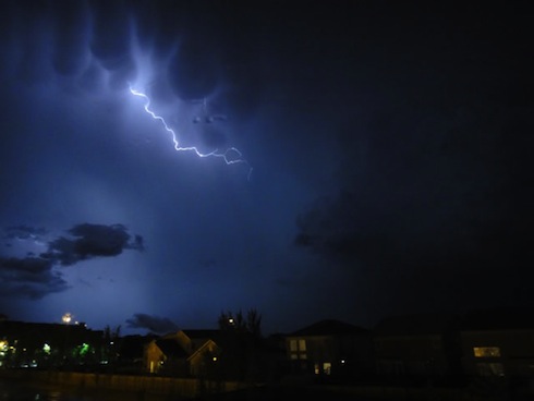
I was able to capture this video from the west-end of town around 9:45 last night, shortly after it had stopped raining. I haven’t seen as much lightning in a single storm as the one last night in a long, long time:

Intense Lightning in Winnipeg (August 18, 2011) from buffaloseven on Vimeo

User submitted photo
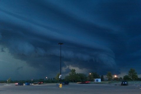
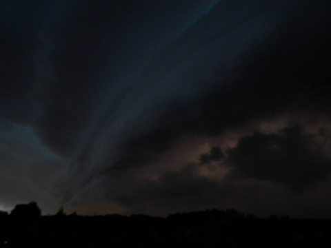
Photo submitted by @hubertguiggsy on Twitter

Twitter user @hubertquiggsy sent me this picture of the storm. It’s a beautiful shot that shows the gust front crossing the city (this picture is facing North) with ample amounts of scud being sucked up into the storm.

Lightning + Mammatus
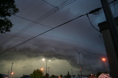
This picture is one of a few great ones at http://www.steinbachweather.ca from the storm as it moved through his area, such as the one above. I highly recommend you visit the site and take a look.

The Weather Network always has plenty of submissions, and last night’s storm was no different; here are some of the highlights:

Clouds
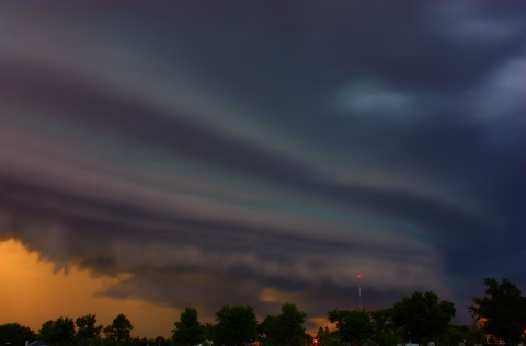
Clouds; submitted by Arienna Paul

This shot (Clouds) shows the impressive structure the leading edge of this storm had, with a well-defined lowering and gust front, complete with beautiful striations running along the main lowering.

Wow!
Wow!; submitted by Christina Unger

Seen from a different angle, Wow! shows us how ominous this storm looked as it approached. Scud getting sucked up into the storm as it advanced on the city, with nothing but ominous behind the gust front. Again, striations can be seen running along the gust front on the upper half of the lowering.

funnel cloud
funnel cloud; submit by Wendy Buleziuk

This shot, taken near East St. Paul, shows another beautiful shelf cloud. The photo is titled “funnel cloud” and I chose not to change that, but it’s important to note that there is no funnel cloud in this picture. The elongated strands of clouds pointing towards the lower left of the picture, protruding from the shelf cloud itself, is known as ‘scud’. This is very low level cloud that is generated by strong lift right ahead of the gust front. These clouds are indicative of a powerful thunderstorm, but do not have a direct connection to the development of funnel clouds or tornadoes.

Thunder Storm Winnipg
Thunder Storm Winnipg (sic); submitted by Greg Pecold

Another beautiful shot of the gust front as it advanced into town.


What’s next for Winnipeg? Cooler weather for today and tomorrow with a mix of sun and clouds. It looks like there’s a chance of showers tomorrow afternoon/evening as a weak disturbance slides through the interlake in the northwest flow, although it looks likely that the showers will stay north of Winnipeg. Sunday may be a little more unsettled as another system moves by and starts to push the cold air out of the province. We’ll see temperatures rebound to close to 30°C Sunday afternoon as the system brings warmer air into the province, and then for the first half of next week we’ll be under the influence of a building upper ridge, which will bring sunshine and temperatures near 30°C for Monday, Tuesday and Wednesday.