A Return to Winter

Colder air is set to return by the end of the week as a low pressure system ushers in Arctic air as winds shift to the northwest behind it.

GFS Sounding for 06Z Thursday

A sounding for 06Z Thursday (midnight-ish tonight) from the GFS model depicting an above-freezing level.

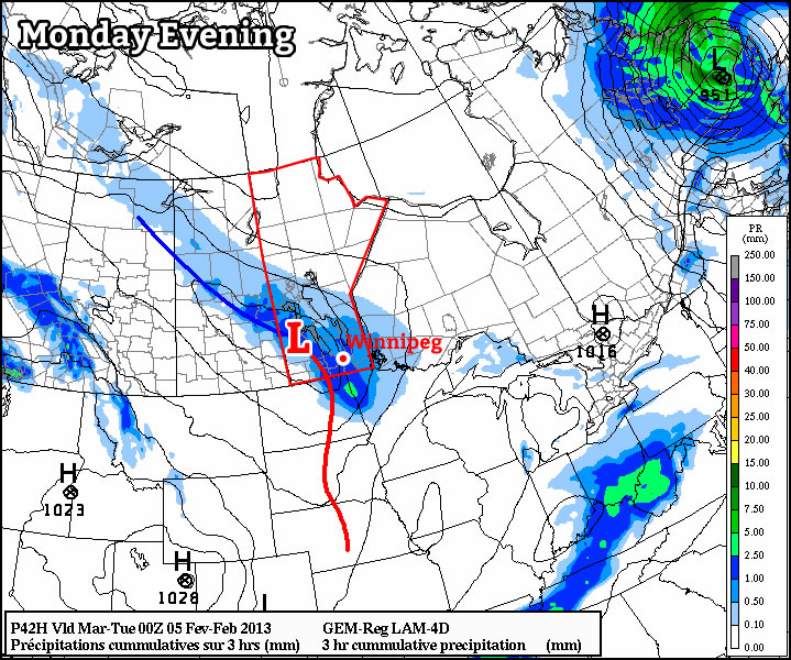
Before the cold weather returns we’ll have one more pleasant day. Although skies will be cloudy today, we’ll see temperatures once again climbing above 0°C through the Red River Valley with a light southerly flow. Conditions will begin to degrade overnight as a low pressure system pushes into Southern Manitoba.

The first threat with this system will be the potential for freezing rain tonight. As the sounding1 above shows, an AFL (Above Freezing Level) with sub-zero surface temperatures will be in place through much of the overnight period before eroding early Thursday morning. The saving grace for the Red River Valley could be that most of the precipitation looks to push north of the valley through the Interlake. If, however, any precipitation manages to wander through the RRV overnight, then there’s certainly a decent chance it’ll fall as freezing rain. Cooler air begins pushing in at all levels early Thursday as we move to the back side of this system and winds switch to the northwest.

Winds will strengthen out of the northwest on Thursday to 40km/h with gusts towards 60km/h as a band of snow slumps southwards with the cold front. At this point, it looks like snow will push into the Red River Valley mid-morning and last until the early evening (6-8PM). Snowfall accumulations will likely be around 5cm. Temperatures will start near -5°C tomorrow morning and fall to -8 or -9°C by the evening. We’ll head to an overnight low of around -15°C tomorrow night.

Sunny skies should dominate Friday and Saturday with highs near -10°C. A weak disturbance looks to bring a chance of light snow to the Red River Valley again on Sunday.


  1. A “sounding” is a way of plotting how the temperature and dewpoint change with height. The sounding is for a single location and plots the temperature/dewpoint with height in pressure coordinates as the vertical axis. 

Major Winter Storm Ushers in Winter

A major Colorado low will bring an end to fall and transform our dry, dusty landscape into a winter wonderland this weekend. This storm will have major impacts on Southern Manitoba with heavy snow producing rapid accumulations and moderate strength winds producing low visibilities and drifting snow.

Satellite Image from 9PM Yesterday

Satellite image from 9PM last night showing location of the main low (marked by the large L) and the area of snow already developed out ahead of it.

Snow will push into southwestern Manitoba this evening as a band of snow that has produced 10-20cm of snow in Southern Saskatchewan spreads eastwards into Manitoba. This snow will intensify over the SW portion of the province overnight and slowly spread eastwards. By tomorrow morning, snow should have pushed across all of southern Manitoba, with light snow falling over the RRV and Whiteshell.

On Saturday, the main low centre associated with this system will push into Minnesota, and things really start to fire up. A surge of moisture will wrap around the north side of this system back into Southern Manitoba resulting in heavy snowfall over the Red River Valley and Whiteshell.

Total QPF

Total QPF amounts (liquid equivalent precipitation) by Sunday morning.

The GEM-GLB model is beginning to have a fairly decent handle on things, however it’s track is likely a little too far south. Amounts seem fairly believable, though, which means widespread accumulations of 15-20cm of snow for all areas south of the Trans-Canada Highway. An axis of heavier snow will exist, likely from near the Pilot Mound region extending NE through (or just south of) Winnipeg and towards Bisset, where amounts will likely end up closer to 20-25cm.

There’s some indications that convective banded precipitation may develop as well; should this happen, there would likely be areas in the Red River Valley (too hard to say exactly where at this time) that could potentially see 30cm+ of snow (that’s a foot if you prefer those imperial measurements).

Winds will remain moderate, only around 30km/h with gusts to 50km/h, however with the intensity of the snowfall, there will likely be periods of near-zero visibility. It’s also very likely that roads will quickly become snow- and ice-covered, with some drifts developing over highways in open areas. Travel will be extremely treacherous on Saturday, and highway conditions will likely not improve until crews have been able to get out and start clearing things on Sunday.

If you have travel plans on Manitoba highways for this weekend, it is important to note that 10-20cm of snow will fall across much of Southern Saskatchewan today. Through yesterday and by the end of today, up to 2 feet of snow will have fallen through central and eastern Montana, and conditions will be equally poor in North Dakota today and tomorrow. This storm will be arriving a little later in NW Ontario, with the precipitation (likely with an area of freezing rain) arriving Saturday morning instead of Friday evening. More or less, unless you’re driving north, you’ll likely be hitting challenging road conditions no matter where you’re headed this weekend. If you do need to travel in a winter storm, make sure you carry a winter survival kit in your vehicle.

Small Disturbance Today; Significant Colorado Low This Weekend

There will be a very slight chance of showers today as a low pushes across the Interlake region, however the bigger news will be this weekend, when a powerful Colorado Low ushers in winter over Southern Manitoba.

The rough track of the upcoming Colorado Low

A satellite image showing the current position and estimated track of the Colorado Low that will impact Southern Manitoba this weekend.

A low pressure system track through the Interlake today will bring 10-15cm of snow through Central Manitoba, north of the track of the low. Through southern Manitoba, there will just be a slight chance of a shower through the afternoon and evening as most areas see a mainly cloudy day with a high near 3 or 4°C. There’s a slight chance to see some sun across many areas this morning, however the likelihood of fog development in any clear areas may mask the chance for sunshine.

Thursday will bring some sunshine and a windy morning, with winds gusting out of the N/NE to 30 or 40km/h behind the system, but should lighten into the afternoon. Temperatures will be cooler than late, with highs only around -1 or 0°C.

By Friday, we’ll begin to feel the impact of the Colorado Low. Winds will begin to pick up out of the northeast as snow begins pushing into SW Manitoba. Snow will make it’s way into the Red River Valley overnight, with steadier snow developing Saturday morning. Disagreement still exists amongst the model runs as to where the heaviest snowfall will be, however the NAEFS (North American Ensemble Forecast System) has been startling consistent over the past few days with painting the heaviest snowfall right over Winnipeg.

Probability of > 10cm of Snowfall

Probability of ≥ 10cm of snowfall from the NAEFS, valid from 12Z November 10th to 00Z November 11th (a 12hr. accumulation).

The NAEFS is showing significant confidence in areas in Southwest Manitoba (Melita, Pilot Mound, Virden and Brandon) regions seeing more than 10cm of snow, with a decent likelihood of people west of the Red River seeing ≥ 10cm as well. North of the Trans-Canada highway, it looks like from Portage to Winnipeg has a sizeable chance of seeing greater accumulations, as well as into the Southern Interlake.

Snow will taper off on Sunday, however significant accumulations will likely have developed in it’s wake. Current indications are that the SE corner of the Red River Valley will see the least snow, and accumulations will increase as you head west and north. In addition to the snow, gusty winds to 50 or 60km/h will push into the Red River Valley as well, producing widespread reductions in visibility due to falling and blowing snow. System-total precipitation looks to be 15-25mm, which when taking into account the expected SLR (snow-to-liquid ratio) of around 10:1, would result in a total of 15-25cm of snow. General estimates for accumulated snowfall by the end of the weekend for a few select sites are:

  • Winnipeg: 15-20cm
  • Steinbach: 10-20cm
  • Morden/Winkler: 15-25cm
  • Portage la Prairie: 15-25cm
  • Brandon: 10-20cm
  • Pilot Mound: 15-25cm
  • Sprague: 5-15cm
  • Victoria Beach: 10-20cm
  • Gimli: 10-15cm

We’ll have more updates on the track of this system as the week progresses. Monitor EC’s Weather Office site for forecasts and any watches or special weather statements as the week progresses. Although the exact timing and intensity of this system may be difficult to pin down, it’s a safe bet to say that driving conditions will likely be extremely poor with ice-covered roads and low visibilities in blowing snow. Conditions in North Dakota will also be quite poor as well this weekend. If you have plans to travel by car/truck this weekend, be sure that you’re prepared for the hazardous weather that will be present. Always carry a winter survival kit in your vehicle if you must travel during winter storms.

Elsewhere in Weather News: November 3rd, 2012

Superstorm Sandy

Since last week’s report on Hurricane Sandy, the storm system made landfall in New Jersey and caused damage that will take months to repair. Just prior to making landfall, Sandy transitioned into an extratropical storm. Hurricane-force winds were still experienced just off the Jersey coast and tropical storm-force winds spanned an incredible 1520km. The storm surge associated with Sandy was the most devastating aspect of the storm as areas along the coast suffered from severe flooding, including Manhattan. At The Battery in New York, the storm surge of 13.88 feet shattered previous records by over two feet. The worst case scenario played out as high tide came in at the same time storm surge was maximized. Sandy also disabled power to over 8.9 million residents on the east coast shortly after it made landfall, and 1.2 million of those are still missing power as of Friday night.

Newark subway flooding

Chilling image as the water poured into the subway in Newark, New Jersey.(Source: @TropicalTidbits)

Sandy

Eight feet of sand cover streets in Cape May, brought in by storm surge. (Source: @AliBurnett)

The hardest hit areas appear to be Staten Island where major flooding occurred and houses for streets on-end were completely flooded and inhabitable. In Breezy Point, New York, a large blaze broke out due to downed power lines that were toppled over from the tropical storm-force winds blowing so fiercely; this resulted in 80 houses burnt down to the ground. In the nearby state of New Jersey, towns along the New Jersey Shore were inundated by water and whole amusement parks could be seen partly submerged.

On the backside of Sandy it was a different story, where in West Virginia it was not rain or storm surge that caused damage, it was the snow. After Sandy moved further north-eastward and snow moved out of the region, it was not uncommon to see 60cm of snow and up to 91cm in some areas, as reported in Richwood, West Virginia.

Sandy snow

Snow depth analysis (some areas of 30-40 inches!) done by the National Weather Service. (Source: NWS)

Although it is still very early in the clean-up, damages are expected to be in the tens of billions – one of the worst storms for the Northeast, ever. The death toll has also risen significantly in the last couple of days, where the tally has reached 109 in the US alone, and 175 across the US and Caribbean combined.

The clean-up will continue to be a chilly one for those without power as temperature highs will only be reaching single digits in the states that were hit the hardest.