Sweltering Summer Heat Returns To Winnipeg

A hot and increasingly humid air mass will bring sweltering summer heat back to Winnipeg.

Get the sunscreen out and make sure that A/C is working: sweltering summer conditions are on their way to Winnipeg! An upper ridge will develop a deep southerly flow through the American Plains and southeastern Prairies, pushing heat and humidity northwards into the region.

Today, Winnipeg will see a high near 27°C with brisk southerly winds of 30 gusting 50 km/h develop. A passing upper disturbance will bring a few clouds to the region this morning, followed by mainly sunny skies for the afternoon. Humidity levels will stay comfortable today. The winds will persist out of the south at around 20 km/h tonight with clear skies and a low near 16°C.

On Thursday, the southerly winds will pick up to 40 gusting 60 km/h as muggier conditions develop over the region. The city will see a high near 29°C with dew points climbing into the upper teens. The muggier conditions will be slightly offset by the wind, but it’ll still feel fairly muggy. Winds will keep up out of the south at around 30 km/h on Thursday night with a low near 20°C.

GDPS 2m Dew Point Temperature Forecast valid 18Z Friday July 24, 2020
Very muggy conditions will develop over southern Manitoba on Friday.

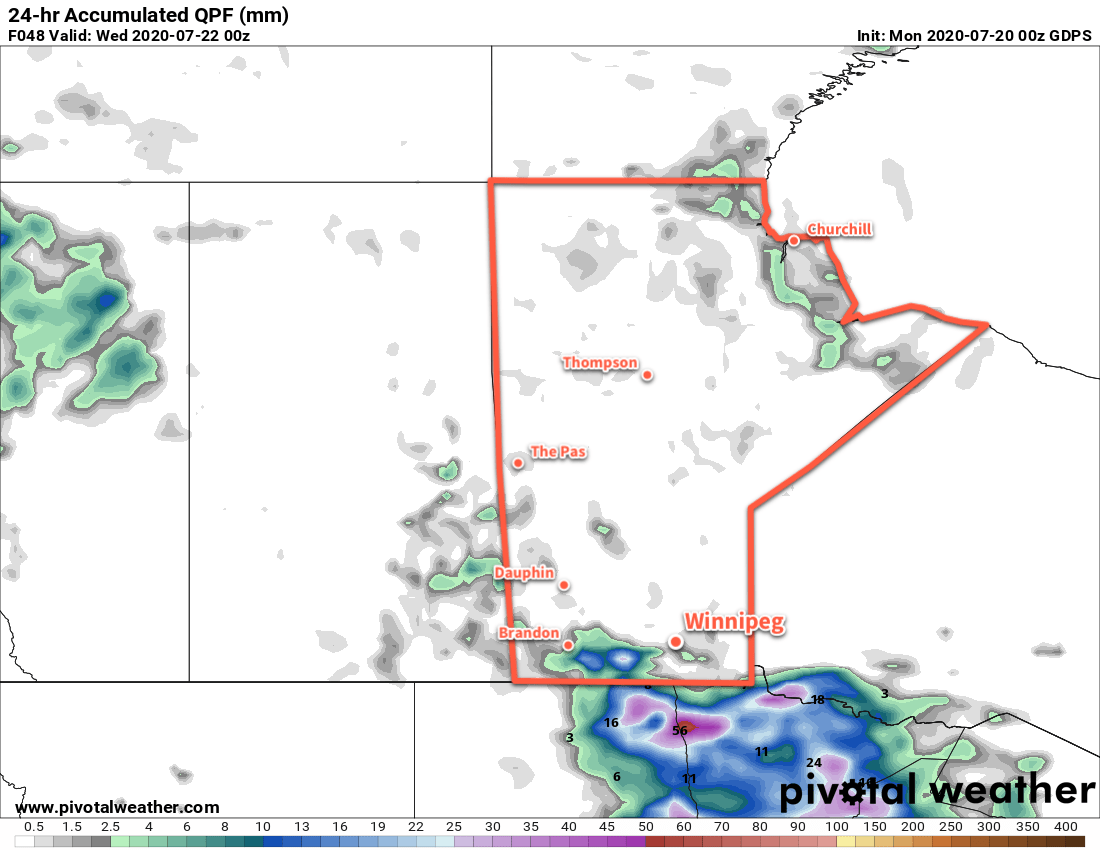
A trough of low pressure pushing eastwards on Thursday night will bring a risk of thunderstorms to southern Manitoba. For Winnipeg and the Red River Valley, the main threat looks to exist between 4 A.M. and 7 A.M. early Friday morning. These thunderstorms, if they develop, could be severe with a primary threat of damaging wind gusts and large hail. Rainfall with these thunderstorms may be intense, but the storms will be moving quickly which will limit accumulations.

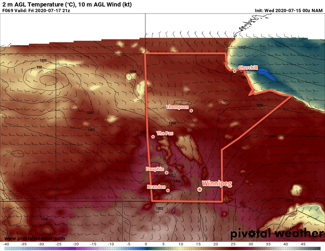
Friday morning will see cloudy conditions in the wake of any potential convection, then skies should mix out midday. It will be an oppressively hot afternoon in Winnipeg with a high near 34°C and dew point in the low 20s. Humidex values in the the low 40s will seem even more oppressive as winds ease in the afternoon.

Winnipeg will see partly cloudy skies on Friday night with a low near 22°C.

Long Range Outlook

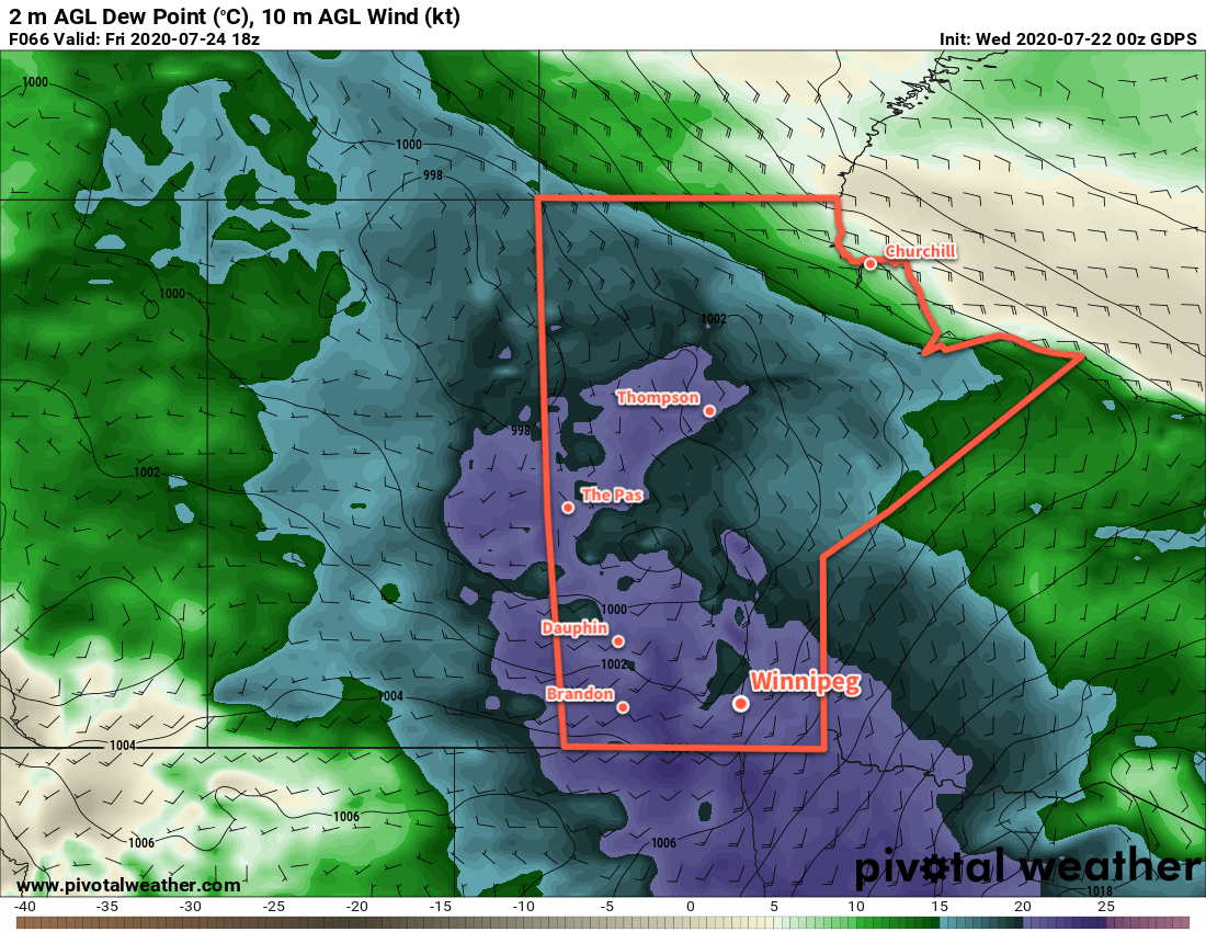
Saturday will bring more hot and humid weather to Winnipeg alongside unsettled conditions as a cold front sweeps through later in the day. Brisk northwest winds will bring seasonal conditions and plenty of sunshine back to the region for Sunday. Next week looks to bring seasonably mild conditions with plenty of sunshine and comfortable humidity levels.

Today’s seasonal daytime high in Winnipeg is 26°C while the seasonal overnight low is 13°C.

Cloudier Conditions on Tuesday, Then Warming Up

Unsettled conditions moving through the region on Tuesday will bring a return of seasonal temperatures to Winnipeg.

Winnipeg will see beautiful conditions for much of the day today with sunshine and light winds. Temperatures will climb to a high near 25°C this afternoon with cloudier conditions moving in for the evening. The region will see a chance of showers through the night into Tuesday morning. Winnipeg will only see a chance of showers through this period, though, with much of the activity passing to the south. Temperatures will head to a low near 15°C tonight.

Tuesday will another day of light winds as a weak low pressure system drifts away to the southeast. After some cloud and chance of showers in the morning, skies should gradually clear in the afternoon. Temperatures will be a bit cooler with a high near 22°C. The city will see partly cloudy skies on Tuesday night with a low near 12°C.

24hr. Accumulated Precipitation Forecast valid 00Z Wednesday July 22, 2020
Showers will move across southern Manitoba on Monday night into Tuesday. Most forecasts show almost all the activity passing to the south of Winnipeg.

Wednesday will see temperatures return to seasonal values in Winnipeg with a high near 25°C. Skies will be partly cloudy with a light southerly wind developing for the afternoon. Cloudier conditions will develop overnight ahead of the next disturbance moving into the area. By early Thursday morning, the Red River Valley may see some thunderstorms rolling through.

Long Range Outlook

Warmer weather will move in for the second half of the week with highs climbing up towards 30°C. Humidity will also move back into the region; forecasts show dew point values increasing back towards 20°C. With the heat and humidity will also come the potential for more thunderstorms. The weekend looks to continue to be warm with gradually easing humidity.

Today’s seasonal daytime high in Winnipeg is 26°C while the seasonal overnight low is 13°C.

Hot Friday Leads To Unsettled Weekend

After a hot Friday, a series of disturbances moving through the region will usher in unsettled conditions.

Before the weather turns, Winnipeg will see a Friday of full on summer heat. Southerly winds will strengthen to 30 gusting 50 km/h with temperatures climbing to a high near 30°C. Those southerly winds will also bring more humidity into the region; dew points will rise to around 17°C today producing humidex values in the mid 30s. Skies will stay sunny for much of the day, but by the afternoon an approaching trough of low pressure will begin to spread cloud into the region.

ECCC Thunderstorm Outlook valid July 17, 2020
Severe thunderstorms are likely over southwestern Manitoba this afternoon with a chance of strong to severe thunderstorms extending eastwards across the Red River Valley this evening. View the full ECCC Thunderstorm Outlook in our Bulletin Viewer.

Through the afternoon and evening hours, the city will see a chance of thunderstorms. The best support for severe activity is over southwestern Manitoba, there will still be a risk of scattered strong to severe thunderstorms in the Red River Valley. Thunderstorm activity will primarily develop along the trough, however a secondary area of thunderstorms will be possible along a cold front following in its wake. Much of the activity will push southwards into North Dakota through the evening hours.

GDPS 12 Hour Precipitation Accumulation Forecast valid 06Z Saturday July 18, 2020
The heaviest rainfall from thunderstorms today is expected closer to the international border.

Skies will stay mixed through the night with temperatures dipping to a low near 17°C. The wind will ease through the early evening.

Saturday will bring cloudier skies to the city, but temperatures should still climb into the mid-20s. Winds will pick up out of the west-northwest in the morning into the 20 to 30 km/h range. A shortwave moving through in the afternoon will likely bring some showers or even a few rumbles of thunder to the Red River Valley. This system is not expected to produce any severe weather. The westerly winds will ease the humidity in the region and allow temperatures to drop into the mid-teens on Saturday night. The city will again see mixed skies through the night.

On Sunday, the upper low responsible for the unsettled pattern will slump through the region, bringing another day of showers and thunderstorms. Temperatures will reach a high in the low 20s with northwest winds of 20 to 30 km/h. Scattered showers and thunderstorms will likely develop north of the region in the morning, then slump south through the afternoon. Skies should finally clear out on Sunday night.

Long Range Outlook

Near-seasonal temperatures will persist through the first half of the week with another chance for rain on Tuesday. In the second half of the week, a warming trend will develop alongside the potential for more thunderstorm activity.

Today’s seasonal daytime high in Winnipeg is 26°C while the seasonal overnight low is 13°C.

Sunshine and Summer Heat

A few beautiful days are on the way for Winnipeg as seasonably warm temperatures return.

An upper low continues to spin over northern Manitoba and support a dry westerly flow over the southern Prairies. As a result, the next few days will look fairly similar as this system slowly spins its way northeastwards.

Today and tomorrow will both see highs near 26°C and lows near 15°C. Winds will be breezy today out of the west at 30 gusting 50 km/h and then ease a bit for Thursday at 20 gusting 40 km/h. Both days will see mainly sunny skies. There will be a slight chance of a late day shower today.

NAM 2m Temperature Forecast valid 21Z Friday July 17, 2020
Hot summer temperatures return on Friday when highs climb back to around 30°C.

On Friday, winds will shift to the south ahead of an approaching low. With winds up to 40 km/h, temperatures will climb to a high near 30°C. Humid conditions will redevelop over the Red River Valley as dew points climb back to around 20°C. In the evening, a trough of low pressure will move through the region, bringing showers and thunderstorms with it. With over 1000 J/kg of MLCAPE and 30+ knots of bulk shear, there is a chance that some of these thunderstorms will be severe. Skies will clear out overnight with winds easing and shifting to the west.

Long Range Outlook

Sunny conditions will stick around for the weekend with highs in the mid-20s. No precipitation is in the forecast for Winnipeg. On Monday, unsettled conditions may redevelop over the region.

Today’s seasonal daytime high in Winnipeg is 26°C while the seasonal overnight low is 13°C.