Winnipeg Dodged The Weekend Rain, But Another Chance On The Way

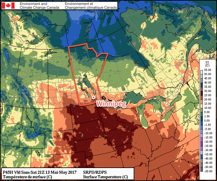
Winnipeg managed to eke out a fairly pleasant Sunday with a cloudy morning giving way to sunny breaks in the afternoon as temperatures climbed up into the low 20’s. Showers that had the potential to impact the city ended up splitting as they entered the Red River Valley; one area headed to the north and across the Interlake while a second area of showers moved through North Dakota. Another chance for rain is on the way, though, with a low pressure system forecast to move through the region on Tuesday.

Attention now turns towards a developing low pressure system in Wyoming that will organize through the day today, strengthen tonight, and then move through the region on Tuesday.

Today will bring increasing cloud cover, particularly through the afternoon, but otherwise will be a pleasant day with a high near 22°C and relatively light winds. Tonight will bring mixed to cloudy skies with a low near 12°C as the low pressure system builds into North Dakota.

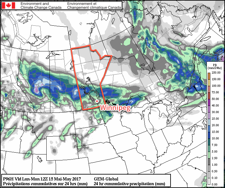
Tuesday’s forecast has a lot of room for error, but we’ll take a stab at broad generalities here. The short version: expect cloudy skies with a very good chance of seeing rain and/or thunderstorms beginning mid- to late-morning and tapering off in the late afternoon or early evening. Winds will pick up out of the north to northwest through the day to around 40 km/h as the low pressure centre moves through the Lake of the Woods region. Temperatures will top out near 15 or 16°C and drop to a low near 7°C on Wednesday night.

Some forecasts hint as much as 25-40*mm* of rain in the Red River Valley on Tuesday.

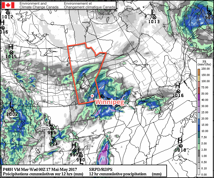
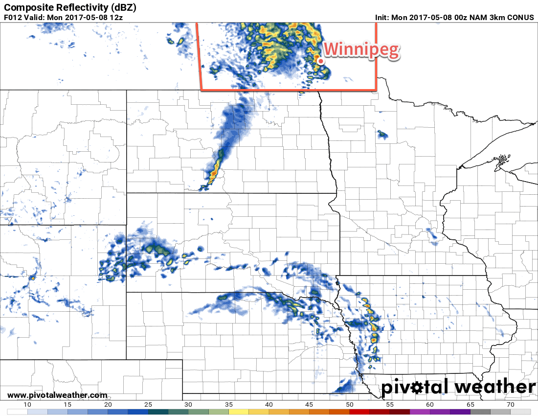
The long version: everything begins on Monday night as an area of thunderstorms develops across western North Dakota on the northern side of the surface low. These storms should expand in coverage through the night, spreading east-northeastwards along a warm front draped southwest-to-northeast across the state. This area of convective rainfall will spread into southwestern Manitoba late Monday night into Tuesday morning, then spread eastwards into the Red River Valley. At this point, there may be thunderstorms still embedded in the area of rainfall, but that risk will diminish through the morning. The rain will move eastwards through the day, then taper off in the late afternoon. With the convective nature of the rainfall, accumulations may end up being highly variable, but overall it seems like 10-20mm is quite likely, with higher amounts possible on a more localized level.

Now this is all fairly prone to error; primarily, a strong low-level jet is expected to develop across South Dakota along the eastern quadrant of the low, which may end up being a foci for thunderstorm development and rob this system of moisture that would have travelled further northwest or pull this system eastwards slightly faster, possibly causing the rain to pass to the southeast of the Red River Valley.

On Wednesday, the winds will remain gusty out of the north with temperatures climbing to a high, optimistically, near 11°C. Skies will start off fairly cloudy, but gradually break up a bit for the afternoon. Significant clearing will likely hold off until the overnight period as temperatures drop to a low near 2°C.

The remainder of the week looks dry with highs slightly below-seasonal and a fair amount of sunshine.

Winnipeg’s seasonal daytime high is currently 20°C while the seasonal overnight low is 5°C.

Weather Set To Turn Warmer and Wetter

A large-scale pattern shift begins today that will bring warmer weather back to the region, but alongside the reprieve from the unseasonably cool temperatures comes a shift towards several days of unsettled weather.

Today will be a quiet day across the Red River Valley with sunny skies and a high near 15°C. Winds will be light as a ridge of high pressure moves across the region. Tonight will also bring fairly clear skies and a low near 4°C.

Warmer air will begin working into the region on Saturday, bringing with it partly cloudy skies as temperatures climb to a high near 19°C. Winds will pick up out of the east to around 30 km/h as a warm front sets up along the US border. Skies will remain partly cloudy overnight as temperatures dip to a low near 9°C with continued easterly winds at 20-30 km/h.

A warm front will lie along the US border on Saturday, with very warm temperatures just across North Dakota.

Sunday will be the turning point for Winnipeg as the first disturbance moves through the region. Winds will continue out of the southeast near 30 km/h until a cold front moves through sometime mid-day into the afternoon. This cold front will support an area of showers or thunderstorms as it moves through the region. As the front moves across southern Manitoba, skies will cloud up as temperatures climb to a high near 20°C.

The GDPS is forecasting a swath of precipitation extending all the way from central Alberta across Saskatchewan and into southern Manitoba Sunday through Sunday night.

Once the front passes, temperatures will cool a bit as the winds taper off. Expect a low near 6°C on Sunday night with partly cloudy skies.

Long Range

The forecast through the first half of next week shows several disturbances moving through the region, however exactly where and how much rain falls with them is still very uncertain.

Expect plenty of cloud, particularly into the middle of the week. Temperatures will be mild both Monday and Tuesday, however a brief cool-down will likely happen mid-week with highs dropping into the low teens.

Winnipeg’s seasonal daytime high is currently 19°C while the seasonal overnight low is 5°C.

Unsettled Monday, Then A Return to Calmer Conditions

Unsettled Monday, Then A Return to Calmer Conditions

Today will be rather unsettled across the Red River Valley as a trough of low pressure moving through the regions supports scattered showers and thunderstorms. After it passes, though, an omega block begins to develop, bringing more settled weather to the region.

Today’s main weather will be two rounds of showers that move through the Red River Valley. The first round will be early this morning, a continuation of showers and thunderstorms that developed in Saskatchewan last night and have pushed eastwards overnight. There is a chance we’ll also see some embedded thunderstorms with this band as it moves through. General morning rainfall will be around 5-10mm in many areas, but due to the convective nature of the precipitation there will be significant variability, with some areas potentially seeing nothing and others seeing higher amounts.

One guess at what the RADAR will look like later this morning as showers move through.

The second wave of showers will develop in the afternoon as a second low pressure centre moves through the region. This band will likely be more focused that the morning activity and primarily impact areas south of the bulk of the morning activity.

Aside from the rain, conditions will be fairly cloudy, although there may be an odd sunny break between the two batches of showers. Temperatures will be mild with a high near 19°C, but winds will be breezy out of the southeast at around 30 km/h. Temperatures will dip down to around 8°C tonight with clearing skies and winds flipping around to the northwest at 10-20 km/h.

Tuesday and Wednesday with both be much sunnier days with north to northwesterly winds. Tuesday will bring a high near 18 or 19°C with temperatures then dropping to a low near 7°C. Wednesday has quite a bit of uncertainty regarding the daytime high. The developing omega block will be pumping warmth across the western Prairies towards Manitoba, but an upper-level low will be moving westwards from Eastern Canada, pushing cooler temperatures into Manitoba from the east and northeast.

This will create a fairly sharp temperature difference somewhere across the southern part of the province, and with a relatively quick change from 19-20°C in the warm air to around 5°C in the cold air. Winnipeg looks to lie in the middle of this zone, with a high likely near 14°C, but a minor shift of this boundary to the north or south would substantially change the expected high temperature.

Long Range

The weather will continue fairly quiet through the remainder of the week with the cooler temperatures mid-week giving way to highs back near 19-20°C for Winnipeg by Friday. The weekend looks mild, but a chance for showers returns to the region on Sunday.

Winnipeg’s seasonal daytime high is currently 18°C while the seasonal overnight low is 4°C.

A Danish Astronaut Captures Rare Blue Flashes

Eric Berger, writing for Ars Technica:

Scientists don’t know much about the mysterious, powerful electric discharges that sometimes occur in the upper levels of the atmosphere in conjunction with thunderstorms. The first photograph of the phenomenon—which can occur as high as about 90km above the surface of the Earth and are known variously as sprites, pixies, elves, or jets—was only taken from Earth in 1989.


Fortunately for scientists interested in these storms, the International Space Station offers an excellent vantage point at an altitude of about 400km. So Danish researchers devised a “Thor experiment”—named after the hammer-wielding Norse god—to study the phenomenon. As part of the experiment, an astronaut on board the station would image thunderstorms under certain conditions, and these observations would be correlated with data collected by satellites and ground-based radar and lightning detection systems.

It has been interesting seeing more and more proper research going into these upward-directed electric discharges from thunderstorms. I recall just in the early 2000’s stories about pilots who had seen these phenomenon but didn’t share their experiences because they felt people may not believe them.

Now we know not only that these blue flashes exist, among other upper-atmosphere related phenomenon, but also that thunderstorms may have a role in troposphere-stratosphere gas exchange.

Interesting stuff. Follow through the link for more photos; the published paper with findings is available here.1


  1. Chanrion, O., T. Neubert, A. Mogensen, Y. Yair, M. Stendel, R. Singh, and D. Siingh (2017), Profuse activity of blue electrical discharges at the tops of thunderstorms, Geophys. Res. Lett., 44, 496–503, doi:10.1002/2016GL071311.