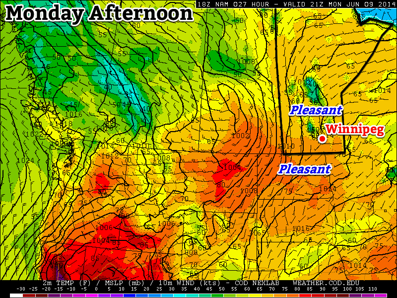
Temperatures will be on their way up as a warmer, more humid air mass begins moving in from the south, but ample cloud will keep sunshine relegated to “rare resource” status.
The cooler weather of the first half of the week is on it’s way out as a broad trough pushes across the Prairies. A southerly flow will spread through Saskatchewan and Manitoba today which will begin tapping into both warmer and more humid air pushing northwards through the American Plains.

The warmer and more humid air will, unfortunately, also result in more unsettled weather bringing plenty of cloud to the region. Multiple disturbances tracking into the region by week’s end will also result in the return of thunderstorm activity.
Another Cool, Cloudy Day
Today will be cool and mostly cloudy through much of the Red River Valley. A few sunny breaks may develop this morning, however with daytime heating more clouds will likely be generated to take their place. There is a slight chance of some showers in Winnipeg and the rest of the Red River Valley beginning late this morning through the afternoon, but anything that develops looks to be fairly light. The high today will be around 5°C below normal at 20°C.[1] Winds will gradually shift from northeasterly this morning to southeasterly by the end of the day, remaining relatively light throughout.
Skies should clear out a fair amount on Wednesday night as temperatures dip to a low near 14°C.
Warmer, Unsettled Weather Moves In
Thursday will be the transition day for the Red River Valley into a warmer, more humid air mass. The day will likely start off mostly sunny – or perhaps a high overcast – with winds out of the southeast increasing to 20-30km/h. The temperature should reach around 26°C, however more notable will the rising dew point[2] which should reach around 17°C by the end of the day. While not too high, the extra humidity will definitely be noticeable by the evening.

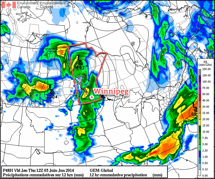
In addition to the rising humidity, cloud cover will spread into the Red River Valley from as a trough works its way into southwestern Manitoba. Showers and thunderstorms will be likely over southeastern Saskatchewan and southwestern Manitoba late in the afternoon and into the evening. Although it appears that the worst – and more likely to be severe – weather will remain in Montana and North Dakota, an isolated severe thunderstorm cannot be ruled out, particularly in SE Saskatchewan.
The afternoon storm activity will weaken after sunset but likely continue through the night pushing eastwards and northwards. There will be a fairly good chance of some shower or thundershower activity tomorrow night through most of the Red River Valley; no severe weather is expected at this point. Thanks to the more humid air, the overnight low will sit around 17°C.
Stormy Friday
Friday will mark a return to wetter weather as a low pressure system lifts northwards out of North Dakota through the Red River Valley, bringing with it a surge of warm, muggy air. Temperatures will climb into the high 20’s – likely around 26 or 27°C – while the dew point rises to around 21 or 22°C, making it feel very muggy.
Thursday’s overnight activity may be lingering in the morning, but it looks quite likely that things will become unstable late in the morning or early in the afternoon again, bringing more shower and thunderstorm activity. It’s still a little early to make very specific predictions, but if things pan out the way it looks now, there would be a very slight chance of severe thunderstorms in the Red River Valley with the main threats being torrential rain causing flash flooding[3] and large hail. We’ll be refining our convective outlook closer to the event since small changes between now and then – particularly with the night-time storms – can dramatically alter the forecast.
Friday night will be cloudier than not with an overnight low of 17°C. It looks fairly likely that a line of thunderstorms will develop through North Dakota along a weak cold front and track northeastwards through the overnight period. At this point it looks like that system will continue to bring a risk of thunderstorms to the Red River Valley through much of the night, but the best support for severe weather looks to remain in North Dakota/Minnesota.
Unsettled Weekend
The unsettled weather will continue through the weekend as yet another upper low begins building into the Prairies (the third in as many weeks). Saturday will likely see showers and thundershowers to the east and north of the Red River Valley to start the day. Much of the day may end up being fairly pleasant, so if that materializes get out and enjoy it!
A shortwave is forecast to move across the province on Saturday night, likely bringing another outbreak of thunderstorm activity. Severe weather may be possible.
Sunday looks to be a nice day, with the sun likely finally making an appearance and a high near the mid-20’s. The humid air should be off into Ontario by Sunday, so it will likely be quite a comfortable afternoon here in the Red River Valley.
- Unless a little more sun develops, then we may see 21 or even 22°C before showers take over. ↩
- Dew point is a measure of how much water is in the air. Compared to relative humidity, it’s a more consistent representation of how humid it is. ↩
- Which wouldn’t be particularly difficult, given the high water levels already in place. ↩