This June has felt more like Spring than Summer so far, but that may be changing this week.
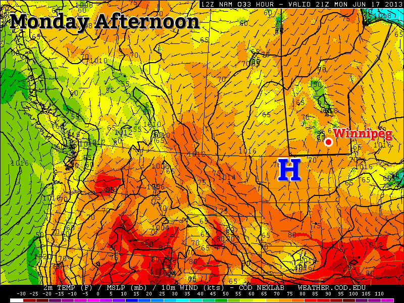
A surface high will be positioned over Southern Manitoba early this week.
Monday and Tuesday
Monday Mainly Sunny 23°C / 12°C
Tuesday Mix of sun and cloud. Chance of showers, risk of a thundershower 25°C / 14°C
Conditions today and tomorrow will be dominated by a surface ridge of high pressure. This high will keep wind speeds relatively light. It should also suppress the risk of showers for the most part, however by Tuesday there may be enough instability for a pop-up shower or thundershower. Temperatures will be in the low twenties today and in the mid twenties on Tuesday.
Wednesday
Wednesday Mainly Sunny. Slight risk of a thunderstorm 27°C / 16°C
Wednesday should be one of the warmer days this week, with high temperatures in the mid to upper twenties. A south-east flow will bring more moisture into the region, so you may notice that Wednesday is a bit more humid than Monday and Tuesday. This additional moisture will once again cause the atmosphere to destabilize, so there is a slight risk of a non-severe thunderstorm in Southern Manitoba.
Late Week
The late week period looks interesting. Models bring a significant stream of moisture up into Southern Manitoba for Thursday and Friday. This along with an incoming jet stream may allow for some strong thunderstorms. However, it is still too early to go into great detail about the storm potential. We’ll be sure to post much more about this in the comments if the risk looks legitimate.
After several fairly nice days in a row, unsettled weather will make it’s return to southern Manitoba as a very powerful upper low moves into the Prairies. The unsettled weather will push through in three distinct phases over the next 3 days, varying from just a few showers to the potential for severe thunderstorms. Without further ado, lets get to it.
Today
We’ll see a very mixed day today as multiple weather features make their way over southern Manitoba. We’ll see a decent chance of some showers this morning as some elevated convection moves through the Red River Valley along the nose of an upper-level jet. We’ll then see a mix of sun and cloud through most of the rest of the day as we climb to a temperature around 24°C. The next bout of unsettled weather will move in this afternoon over SW Manitoba and in the late afternoon/evening for the Red River Valley as two distinct features move into the Red River Valley.
Through the afternoon the 850mb low-level jet (LLJ) will be working it’s way eastwards across Southern Manitoba and, while 700mb temperatures are forecast to sit around 6 or 7°C – a little high to get much convection – the LLJ has had a history of being able to get some heavy showers or weak thunderstorms going despite the marginal instability. This first feature will not likely produce any severe weather.
The second feature moving across southern Manitoba will be a surface trough extending from a low pressure centre in central Saskatchewan southeastwards through southern Manitoba. This trough has the potential to produce severe weather in Southern Manitoba, but the threat has to be considered fairly conditional due to two uncertainties:
Uncertainty in cloud coverage could result in cooler daytime highs than expected; the warmer it gets today the more likely storms will develop.
The warm temperatures at 700mb may be enough to prevent convection from developing; the trough will have fairly strong convergence associated with it, and there may be enough broad, synoptic-scale lift to overcome the warm air aloft.
My gut feeling is that we will see storms develop this afternoon; this trough has had a history of producing thunderstorms the past 3 days in a row. Going with this idea, it’s likely storms will initiate somewhere in SW Manitoba in the mid-to-late afternoon and slowly progress eastwards. The main threats with the storms will be:
Heavy Rain: Precipitable water (PWAT) values are expected to sit around 35–40mm this afternoon thanks to quite a deep layer of moisture moving across the province with this system. That’s a lot of water for these storms to work with. The trough line won’t be moving too quickly and, especially near the western escarpment of the RRV, conditions will be somewhat conducive to the development of quasi-stationary storms. Slow or non-existent storm motion could result in rapid accumulations of 2+” of rain in isolated storms.
Strong Straight-line Winds/Tornadoes: 0–6km bulk shear values will sit around 40kt this afternoon with favourable veering profiles. There’s certainly enough directional shear for storms to develop into supercells, however there may be a lack of backing in the lowest levels to produce enough low-level shear for tornadoes to become a threat. For that reason, I think the most likely wind-related threat would be the potential for strong straight-line winds. This threat would be secondary to the heavy rainfall threat.
Fortunately, with limited CAPE, a high freezing level and significantly weaker winds in the upper atmosphere than on Monday, hail will not likely pose much of a threat today. The showers and thunderstorms should develop this afternoon over SW Manitoba, push through the Red River Valley this evening and lift northwards into the Interlake, flattening out into an area of rain overnight. We’ll see clearing skies overnight here in Winnipeg as we drop to a low of around 14°C.
Saturday & Sunday
Through the weekend we’ll see the passage of the upper low as it moves from central Saskatchewan into NW Ontario. It will begin to move into the region on Saturday and allow things to broadly destabilize in the afternoon which will produce scattered showers and thundershowers. No severe weather is expected. We’ll see a high near 23°C on Saturday and then dip to a low of 12°C overnight with some cloudy periods. On Sunday, we’ll see more cloud than sun and a high near 21°C with scattered showers throughout southern Manitoba. Skies will clear out on Sunday night as we dip to near 10°C.
Next Week
It looks nice for the start of next week with sunshine returning and temperatures climbing back into the mid-to-upper 20’s. At this time it looks like another system will move through late next week bringing another chance of showers and thunderstorms.
This week will start out fairly nice, with the exception of some showers on Monday.
A weather system will bring showers to Manitoba on Monday
Monday
Monday Mainly cloudy a chance of showers, then clearing. 21°C / 10°C
Today will be a mixed day weather-wise. Showers are likely in the morning as a strong upper-level jet stream induces lift over the area. These showers are expected to taper off by this afternoon, with clearing skies thereafter. Once skies clear, temperatures should warm into the low twenties.
Tuesday and Wednesday
Tuesday and Wednesday look to be fairly similar days in Southern Manitoba. Both days should be mainy sunny with temperatures in the mid twenties. The wind should be fairly light, making conditions ideal.
Tuesday Mainly Sunny 25°C / 13°C
Wednesday Mainly Sunny 25°C / 12°C
Late Week
The late week forecast is unclear at this point. A strong longwave trough[1] will come onshore late in the week. This trough may generate a series of thunderstorm days across the Canadian Prairies and Northern US Plains. At this point the location and timing of storms is not known, but more details on this situation will be available as the week progresses.
A longwave trough is a large-scale dip in the jet stream that is usually associated with strong weather systems and/or severe weather outbreaks. ↩
The warm, mostly sunny weather of the past few days will give way to more unsettled conditions as a low pressure system anchors itself in Central Saskatchewan allowing a trough to sit over Southern Manitoba as a second low works it’s way across the Northern Plains of the United States. Showers will try to get going across Southern Manitoba but their coverage will be heavily limited by a lack of upper-level support over the region.
Today
24°C / 12°C Sunny with cloudy periods. Chance of showers or a thunderstorm in the afternoon.
We’ll start off with some lingering clouds this morning with a chance of a few scattered showers as the remnants of a weak cold front wash out over the Red River Valley. We’ll then see a bit of short-lived clearing before skies cloud up this afternoon once we get warm enough to get some convection going. There will be enough instability around to produce a few afternoon showers or perhaps even a weak thunderstorm or two. Lifted Index values will be sitting at only –1 or –2°C which represents only marginal instability and CAPEs agree with values only around 500–750J/kg.
With little forcing in the area, the most favourable area for showers or thunderstorms will be near subtle convergence features; in our case, that will mean near either the western escarpment of the Red River Valley or any lake breeze convergence lines that form to the north and northwest of the city. At the moment it’s looking like the most potential for a thunderstorm sits west of Winnipeg in the Red River Valley, but there’s certainly a chance we may see an afternoon thunderstorm here in the city. Aside from the potential showers & thunderstorms, it will actually be a fairly pleasant day. Winds will be fairly light through the day and we’ll be climb to a high near 24°C. Skies will clear tonight as we head to a low of around 12°C.
Saturday & Sunday
Saturday 23°C / 12°C Increasing cloudiness then a few showers or rain.
Sunday 24°C / 12·C Mix of sun and clouds. Showers likely southwest of Winnipeg.
After a sunny start, skies will cloud over on Saturday as a trough connecting a low pressure system in central Saskatchewan and a low pressure system pushing into the Dakotas. There will some showers ahead of the trough line that will push through the Red River Valley in the afternoon. Rainfall amounts won’t be anything significant, but a localized 5–10mm can’t be ruled out. We’ll see a high near 23°C and an overnight low once again sitting near 12°C under clearing skies. Sunday will be a mix of sun and clouds with showers likely south and west of the Red River Valley. The high for the day will be around 24°C with an overnight low into Monday morning of about 12°C once again.