Multi-Day Severe Weather Setup Leads to Tornadoes, Flash Flooding in Oklahoma

Early May is typically when the severe weather season really ramps up in the US Plains and this week has certainly lived up to that. The region has seen severe weather every day since Wednesday and is expected to see more today. A western troughing pattern has been dominant the past few days, allowing a strong southerly flow to take place in the lower levels of the atmosphere – advecting in plenty of moisture from the Gulf of Mexico located nearby. High levels of instability, coupled with enough shear to support supercells was in place.

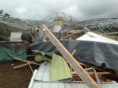
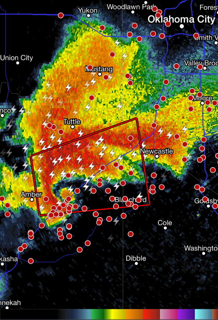
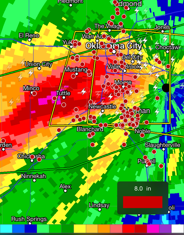
[map autofit=”1″ disable_scrollwheel=”1″] [pin tooltip=”Bridge Creek”]Bridge Creek, ok[/pin] [pin]Norman[/pin] [/map]

The worst day of the outbreak tornado-wise occurred on Wednesday where 48 tornadoes touched down from Nebraska, all the way down to Texas. A particularly dangerous situation unfolded in Oklahoma as a supercell with a history of producing tornadoes moved northeast along I-44 and through the large city of Norman where it dropped a tornado, later rated EF-1. The same supercell also produced an EF-2 tornado near Bridge Creek, shortly before it dropped the Norman tornado. Tornadoes were not the only threat on Wednesday; significant rains fell across Oklahoma, including Oklahoma City, which saw trailing supercells hit the city and as a result severe flash flooding. One person died from the storms, while a few dozen were injured. Ditches became raging creeks that spilled their banks onto highways and residential areas. It’s not uncommon to see supercells drop 100mm of rain or more in an hour. Radar indicated that some areas just southwest of Oklahoma City saw over 250mm on Wednesday. Numerous stations in the area broke their daily rainfall records from this event. A state of emergency was issued in 12 counties as a result of the storms.

Chickasha Supercell
The tornadic supercell that hit Norman in its early stages, showing an obvious hook. (Source: Radarscope)
Oklahoma Flooding Rains
Storm total accumulation for Wednesday through 9pm shows areas of over 250mm (pink areas). (Source: Radarscope)

More severe weather is expected today as the trough shifts slightly eastwards. There’s a chance that today could be the second significant tornado day in less than a week in the Plains – Kansas, southeast Colorado and northern Oklahoma regions are under the gun. However, there are still a few uncertainties due to the models showing some mid-day convection possibly limiting the heating. The Storm Prediction Center had issued a moderate risk for the region as of Friday night. Regardless of what happens in the first half of the day, there will be severe storms; residents in the region will have to keep an eye on the sky for large hail, severe winds, torrential rains and even tornadoes!

Elsewhere in Weather News: April 11th, 2015

Severe Weather Outbreak Strikes Plains and Midwest

As April rolls around the severe weather season in the United States is on an uptick, and with that comes a higher threat for tornadoes. The latest severe weather outbreak occurred Wednesday and Thursday of this past week and hit hardest a few small communities of northern Illinois.

[map autofit=”1″ disable_scrollwheel=”1″] [pin]Medicine Lodge, Kansas[/pin] [pin]Fairdale, Illinois[/pin] [/map]

The setup on Wednesday was a fairly typical setup that you would see for a Southern Plains outbreak – surface low in central Kansas with sharp warm front extending eastwards and dryline extending southwards. This, combined with an upper-level trough moving in aloft, destabilized the environment sufficiently for supercells. Only a few tornadoes were observed on Wednesday, with most spotted just west of Wichita (including a large cone tornado near Medicine Lodge) and one unconfirmed in western Oklahoma. No damage was reported as tornadoes mainly touched down in open areas.

Thursday was a different story however, as the system progressed eastwards. The main risk for the day zeroed in to an area near the triple point where both CAPE and shear values were high and surface winds were slightly more backed compared to further south along the cold front. Once again, supercells were triggered in the early evening hours – this time in northern Illinois. One supercell near the triple point stood out from the others however; there no other cells to its southeast to inhibit growth and it latched along the warm front. What came of this supercell was a long tracked tornado that was on the ground for an estimated 25-35km and measured just less than a kilometre in width. It tore through mostly rural area and outskirts of two other towns before striking the town of Fairdale, Ill, which sustained heavy damage from the twister. On Friday, National Weather Service teams were out to examine the damage and gave it a preliminary rating of EF-4 (winds of about 315km/h). Two people were killed and a dozen more injured by the tornado. Cleanup is currently underway in the town as calmer weather sets in for the weekend.

Note: there is some strong language near the end of the video clip

Elsewhere in Weather News: June 28th, 2014

Active Week in Southern Ontario

It’s been a fairly uneventful week worldwide regarding severe weather events. However, southern Ontario has seen its fair share of significant weather events this past week including a few tornadoes and flooding in Toronto.

Last Tuesday two tornadoes touched down in Ontario causing some damage to homes and barns. The first tornado reported touched down in New Tecumseth, ONT – a town located about 100km from Mississauga. The EF-1 tornado did significant damage to a barn which was almost completely torn apart, and 15 buildings (one with structural damage) along a path of 10 kilometres. Only a horse perished in the tornado; no residents were injured or killed. The second tornado has not yet been confirmed by Environment Canada as of yet but there is speculation that it occurred near Hawkesbury on the same day. The New Tecumseth tornado comes in the wake of the Angus, EF-2, tornado which did significant damage to over 100 homes two weeks ago. Ontario’s tornado count is already at six for the year while the average for tornadoes in southern Ontario is between eight and ten.

The barn destroyed in the New Tecumseth area by the tornado on Tuesday. (Source: Rob Cooper/CTV)

Southern Ontario has also seen flooding problems this past Wednesday. A slack flow aloft combined with a disturbance moving in made for fairly slow moving cells that trailed each other in the Toronto area. This generated some fairly significant street flooding in the area, some power outages as well as part of the city’s subway system being put out of order for a few hours. Water rescues also had to be executed due to motorists stranded in their vehicles on one of the city’s large parkways. Some recorded rainfall accumulations were in excess of 30mm in the region Wednesday evening. Since then the water has subsided and the power is back for residents that were left in the dark.

Elsewhere in Weather News: June 21st, 2014

South Dakota Wessington Springs Tornado – June 18th, 2014

Three members of A Weather Moment team headed out to South Dakota this past Wednesday to chase severe storms and try to catch a tornado. It turned out to be quite the event. Julien has written a summary of what how the chase unfolded.

We left Winnipeg bright and early at 7 am on Wednesday and headed south. Our plan for the day was to target the warm front/triple point in southeastern South Dakota. We reached Fargo by late morning. After getting our internet worked out and had lunch, we continued south to Sioux Falls, South Dakota to reassess things (by then it was mid/late afternoon). We decided to head west a bit to Mitchell first, then Plankinton, SD. It was oppressively humid with dewpoints in the low to mid 20’s and temperatures near 30°C. In fact, as I walked out of the car, my glasses were fogging up! These yielded MLCAPE values around 5,500J/kg resulting in an explosive environment for any storm that formed.

By then, storms to our northwest were strengthening rapidly and rotation became evident on radar imagery. A tornado was also reported by another storms chaser. We were concerned of the possibility that additional storms would fire off south of the existing ones and become dominant. As a result, we decided to wait a little longer. Nothing new was really forming due to a strong cap, so we decided to head west then north of Kimball, SD to view the existing storms. We were impressed! Towers were shooting up extremely rapidly and there was decent structure to the storm. Rotation could be seen in some parts of the storm.

Not too long later, we repositioned north of Plankinton, SD, which was eastward. As we got closer to the storm, two funnels poked out of the trees! It was evident that the one in the distance was a tornado. However, the second funnel was hard to say if it was touching down or not because it was not condensed all the way to the ground. However, it’s impressive seeing 2 funnels simultaneously!

One funnel and a tornado simultaneously, with the one on the left touching down. (Taken by Matt)

We followed the storm eastward and the dominant tornado was not giving up! Even though we were well in the distance far away from the tornado, we could clearly see its circulating winds moving rapidly which was quite impressive. Unfortunately, we did occasionally see debris being picked up. It took several minutes for the tornado to finally rope out and lift… before we witnessed it strengthening and enlarging again briefly. Then it dissipated and that was it for tornadoes for us for the day. After our chase was finished, we had heard that there was serious damage to the town of Wessington Springs, SD however no serious injuries had been reported thankfully.

Stovepipe tornado we observed. (Taken by Matt)

We slowly made our way east to Brookings, SD for the night at a hotel. We left back for Winnipeg Thursday morning before 11 am and reached Winnipeg by around 6 pm or so after stopping by at Longhorns restaurant for a well-deserved tornado steak dinner in Fargo. The next day NWS had done a damage survey of the tornado and rated it an EF-2 tornado, the strongest tornado we had ever witnessed. Overall, it was well worth the trip!

This trough not only produced tornadoes on Wednesday in South Dakota, but also on Monday and Tuesday in Nebraska, including the incredible supercell near Pilger, NE that produced two large wedge tornadoes simultaneously. The upcoming pattern definitely looks calmer with upper flow slacking up in the US Plains; possibly hinting that summer is right around the corner for the region.