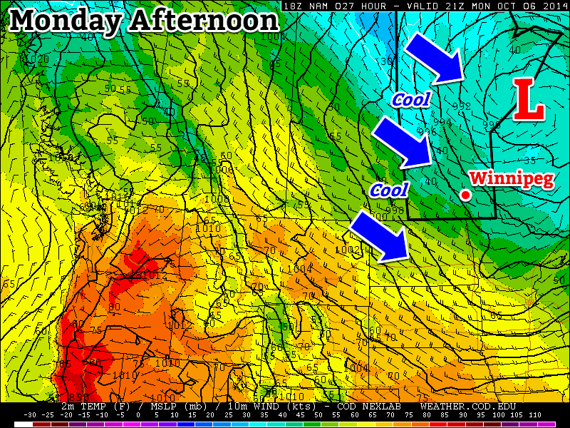
A large upper-level low pressure system over northern Ontario will bring us chilly weather to start the week. Unfortunately, this means below-normal temperatures and frequent opportunities for showers.
An upper low over Ontario will bring cool conditions to southern Manitoba this week
Monday
Monday
7°C / 2°C
Mainly cloudy with chance of showers
Today will be cool, cloudy, and breezy as that large upper-level low over Ontario brings a cool north-westerly flow to southern Manitoba. There will be a chance of showers throughout the day, as a band of light precipitation pushes down from the north.
Tuesday
Tuesday
7°C / -1°C
Mainly cloudy
Tuesday’s weather will be very similar to today’s. Skies will once again be mainly cloudy with a chance of showers. Unfortunately, it will also remain breezy as that upper low to our east maintains a decent pressure gradient across Manitoba.
Wednesday
Wednesday
8°C / -3°C
Mix of sun and cloud
It looks like Wednesday’s weather may begin to see some improvement over the conditions from earlier in the week. Temperature won’t warm by much, but winds should be a bit lighter. The chance for showers looks to be gone on Wednesday, and we should even see some sunshine.
Long Range
The long range forecast isn’t looking all that great at this point. The current forecast calls for a surface high to build into Manitoba late this week as that nasty upper low finally moves off. This will likely mean sunnier skies, but also a good chance for some solid freezing nights, and relatively cool daytime temperatures. Models hint at a warming trend from next weekend into the following week, though it isn’t currently expected to be an extended warm-spell…but we shall see what actually happens!
Unsettled weather will mark the start of the last weekend of July, but conditions will improve for a rather pleasant end and persist into a fairly dry and seasonal start to next week.
Friday: Thunderstorms Possible
Friday
25°C / 15°C
Chance of showers or thunderstorms
Today is off to a cloudy start with a few showers likely through the Red River Valley[1] as the remnants of the overnight activity push off to our east. Skies will remain mostly cloudy until the cold front that brought copious amounts of severe weather to Saskatchewan yesterday pushes through the Red River Valley early this afternoon.
As that cold front moves eastwards, it’s likely that more thunderstorms will fire up along it. Dewpoints in the upper teens will combine with daytime highs in the mid–20’s to produce MUCAPE values as high as 2000J/kg ahead of the front. Shear will be marginal with only around 25–30kt of surface-to–500mb bulk shear and the vertical wind profile isn’t particularly favourable for severe weather. The cold front will be enough of a trigger, although it will be weaker than yesterday and not offer nearly as much forcing as it did then.
As a result, thunderstorms will likely fire up somewhere in the central or eastern Red River Valley and push into the Whiteshell and far SE Manitoba this afternoon. At this point it doesn’t look like there will be an organized severe weather threat, but we’ll be taking a look a little later this morning to assess whether or not the severe threat needs upgrading.
The HRRR forecast shows a line of showers and thunderstorms pushing eastwards along the cold front this morning.
Other than the storms, the day will be pleasant. Before the cold front passes the Red River Valley will be under a relatively light southerly or southeasterly wind. It will be fairly humid and temperatures in the low 20’s until the passage of the front, after which westerly winds at 30–40km/h bring in much drier air. The afternoon sunshine should help our daytime high climb to around 25°C.
Temperatures will drop to around 14°C under clear skies and light winds tonight.
Showery Saturday
Saturday
24°C / 13°C
Mainly cloudy with widespread showers
Tomorrow will be the least pleasant day of the next few. A strong upper-level low will slide across Southern Manitoba through the day, producing widespread showers underneath it. There may be a few isolated thunderstorms, but for the most part most areas in Southern Manitoba will be seeing a fairly wet day. Winds will generally be 20–30km/h through much of the day, shifting from southwesterly or westerly to northerly through the day and overnight.
Skies will begin to clear overnight as the temperature drops to around 13°C.
Sunny Sunday
Sunday
24°C / 13°C
Mainly sunny
Sunday will likely start off with some low cloud trapped in the boundary layer making for mixed to mostly cloudy skies. As the temperature rises through the morning, the clouds will gradually break up leading to a mainly sunny afternoon with some scattered clouds. Highs will be around the 24–25°C mark and temperatures will drop to around 13°C once again on Sunday night.
This pleasant weather will continue through the first half of next week. Another strong ridge is forecast to build into BC/Alberta, which will keep temperatures seasonal[2] and the weather dry.
Full discretion: I’m writing this on Thursday evening, and still unsure on how much of Thursday night’s convective activity will survive to the Red River Valley. ↩
Seasonal highs in Winnipeg right now are around 26°C. Seasonal lows are around 13°C. ↩
Wet weather will finally give way this weekend to sunshine and warm temperatures as an upper ridge building into the western Prairies induces a dryer, more stable northwesterly flow aloft over Manitoba.
Friday 25°C / 14°C A few morning showers giving way to afternoon clearning.
Saturday 27°C / 14°C Mainly sunny.
Sunday 28°C / 15°C Sunny.
We’ll see a few morning showers today as the dying remnants of an upper low cycle their way out of the province. Once the scattered showers end in the morning, skies will begin to gradually clear through the afternoon. We’ll see a high of 25 or 26°C with winds out of the north at 20–30km/h. We’ll see clear skies tonight as temperatures drop to around 14°C.
A high pressure system will begin to push eastwards across the Prairies this weekend which will bring some beautiful, dry weather to Southern Manitoba. Temperatures will climb into the high 20’s this weekend under sunny skies with no chance of rain in sight. Overnight lows will dip to around 15°C.
The next chance of precipitation looks to be in the first half of next week as a slow-moving low pressure system meanders across the Prairies. Until then, enjoy a sunny, warm and dry weekend!
Cooler, more seasonable, weather is going to move into Southern Manitoba for the week ahead as a large upper trough swings into the region.
GEM-REG 500mb wind field valid Tuesday morning. A deep upper low is straddling the SK MB border with a trough extending to the SW denoted by the dashed black line.
A strong upper low sitting over the northern Prairies is in the process of stalling out over Northern Manitoba as it’s been captured by a significant long-wave trough. While today will be quite pleasant with sunshine and daytime highs across the Red River Valley near 28°C, the aforementioned trough will be moving into our region tomorrow.
With this system stalled out over the province, we’ll be stuck under cooler air for the rest of the week; daytime highs will sit around the low-20’s under a mix of sun and clouds or cloudy skies. Winds are expected to be fairly light through the week and overnight lows will sit around 10-13°C.
While Northern Manitoba will be fairly wet this week, it looks like we’ll be relatively dry in Southern Manitoba. The best chance for rain looks to be on Wednesday night into Thursday as a small reinforcing trough swings through the Red River Valley. Things then look to improve slightly over the weekend as an upper ridge starts to push across the Prairies, however another powerful low pressure system is forecast to move through Southern Manitoba and bring another batch of cooler air across the Prairies next week as it ushers in another cold trough.