Elsewhere in Weather News: November 16th, 2013

Typhoon Haiyan Final Update, Moderate Risk for Midwest US

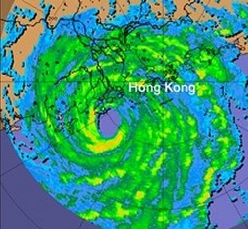
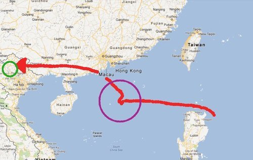
It’s been over a week since super typhoon Haiyan made landfall in the Philippines and a second landfall over Vietnam. The impacts in the Philippines and Vietnam are just now starting to surface and the reports coming out of the countries are not good.

Vietnam had had quite a bit of time to prepare for the storm and 70,000 people were evacuated from low lying areas. These preventive measures surely saved lives in the flood-prone and landslide-prone areas of Vietnam, but unfortunately five people still lost their lives in the floods. Storm surge was not as big an issue as it was for the Philippines as Haiyan had significantly weakened by the time it made landfall in Vietnam.

For the Philippines the death toll continues to climb (3,600 people) as the cleanup continues. One neighbourhood of Tacloban City of about 10,000 people has been literally washed off the map according to the city’s mayor, with no houses left. An early estimate for the damage is 12-15 billion dollars.


Aerial picture of Guiuan, one of the hardest hit areas, to the east of Tacloban. (Source: National Post)

Unfortunately, this past week another tropical disturbance made its way to Vietnam and brought anywhere from 250mm to 500mm in the central part this past week. To the already saturated grounds, this was enough to cause some more flash flooding. As of Friday night’s reports 3,500 houses had been lost and power was out for various cities in central Vietnam. In total, 17 people had lost their lives from this event.

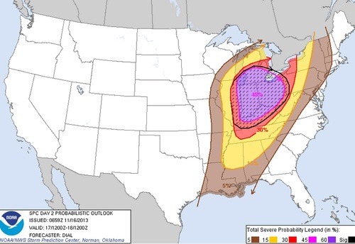
In other weather news this week, a negatively tilted trough will be making its way across the US Midwest and has the chance to produce some severe weather on Sunday. SPC has outlined a 45% hatched area, moderate risk stretching up to Southern Ontario. Though CAPE is limited, shear is quite impressive, thus, severe winds will be the main threat with this event. If the sun does get a chance to heat up, brief spin-ups could become a threat with the low cloud bases. It is not all that common to see severe events of this magnitude stretching up to Southern Ontario in the middle of November.


45% hatched area for the US Midwest, the main threat will be wind damage. (Source: SPC)

Elsewhere in Weather News: July 28th, 2012

Severe Typhoon Vicente Plows through Southern Asia

This past week, typhoon Vicente spun up in the Pacific Ocean and made landfall near Hong Kong on July 23rd. The severe typhoon, of category 2 hurricane strength, amassed winds of between 155km/h just before it made landfall about 100 kilometres to the south-west of Hong Kong’s city core. Although the typhoon first touched land outside of Hong Kong, its hurricane-force winds did extend out into the city. In consequence, the Hong Kong Observatory (HKO) issued a level 10 advisory – the highest possible on the scale – advising residents to stay inside and closing non-essential services as well as schools. The level 10 advisory had only occurred 13 times since 1946, with this most recent advisory being the first in the 21st century (the last level 10 advisory was issued in 1999). Vicente had somewhat of an unusual track, being stationary 300 kilometres to the south of Hong Kong for 15 hours then strengthening significantly before moving inland the following day. The strengthening that occurred with Vicente, within this short amount of time (48h), had never been observed this close to land with prior significant typhoons that struck the region.

Vicente

RADAR image of Vicente as he made landfall on the afternoon of July 23rd. (Source: HKO)

Although Vicente forced the HKO to issue a level 10 advisory, damage was fairly minimal in the city – only minor damage to buildings was reported, but no structural damage. Flights in and out of Hong Kong were either cancelled or delayed which did cause some grief to travellers in the region.

Vicente did not stop its tracks in Hong Kong. It continued westward towards Southern China and Northern Vietnam where it dumped large amounts of rain during its passage. This in turn caused landslides and flooding in the mountainous region of Northern Vietnam, killing seven people with three still missing. The Vietnamese government has sent out rescue teams to look for the residents still missing. Damage is quite significant in the region, with most houses and crops destroyed due to the flash flooding and landslides.

Vicente Track

Red line depicting Vicente’s track, green circle are the areas of Vietnam affected by the flooding and purple circle is the area where Vicente intensified quickly. (Map credit: Google Maps)

Another tropical depression appears to be forming to the east of the Philippines with some thunderstorm activity, which is something to keep an eye on in the coming week!

Tropical disturbance

The tropical disturbance east of the Philippines. (Source: HKO)