Elsewhere in Weather News: August 24th, 2013

California Wildfires Threaten National Park

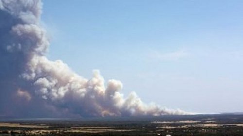
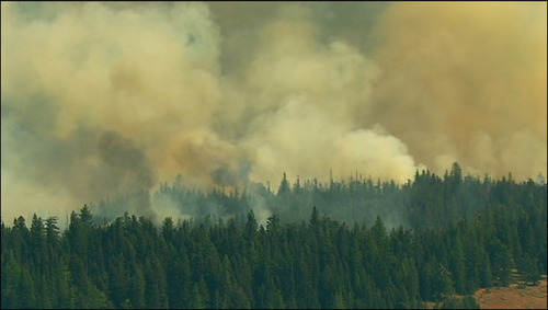
A small wildfire started about a week ago in the back country trails of the California forests near Yosemite National Park has now turned into a raging wildfire. The wildfire which was initially located outside park boundaries has recently encroached on the national park territory. Covering about 425 square kilometers, the fire is only 2% contained bringing concern to many residents in the area who are under voluntary evacuations. Twelve buildings have been damaged or destroyed by fire already and another 4,500 around Yosemite are at risk. In all, 7,000 firefighters were brought in to battle the wildfire.

Wildfire smoke

Visible satellite shows extensive amount of smoke in eastern California. Smoke outlined in orange, red the location of the Yosemite fire. (Source: CoD satellite)

Very dry heat has been in place over the region for the last week priming the conditions for wildfires. Relative humidity values are expected to remain in the single digits, combined with temperatures in the mid to high twenties, no relief will be provided to the firemen battling the blaze. Drought has persisted since the beginning of summer for much of California and as of Friday 98% of the state is experiencing drought, with the severity ranging from moderately dry to extreme. Due to the dry conditions, 15-20 large wildfires are currently burning in California.

Usually, the wildfire risk peaks in late September in California as the Santa Ana winds come into play. Santa Ana winds are severe winds that are funneled through the mountains. As these winds are funneled through and descend in height (moving towards the coast) they are heated by natural processes, namely, adiabatic heating, causing for extremely hot and dry weather. These easily spread wildfires by blowing embers towards flammable vegetation.

Elsewhere in Weather News: June 15th, 2013

Colorado’s Black Forest Fire

Residents of Colorado Springs and surrounding areas have been on high alert this past week because of wildfires in the area that are burning out of control. Currently, there are three large fires burning in Colorado. The largest wildfire of the trio is known as the Black Forest Fire. This fire covers about 60 square kilometers and has destroyed about 400 homes already, as of Friday evening. Unfortunately, two people have also perished from this fire. On Friday thunderstorms moved over the area but although they brought much needed rain, they also had undesired effects such as cloud to ground lightning strikes that potentially sparked up new fires. The Black Forest Fire is around 30 percent contained as of Friday evening so firefighters still have quite a bit of work to do this weekend.

The reason for such extreme wildfire events this spring in Colorado can be associated with drought. The severe drought that was seen throughout the US Plains last year and into this spring has shifted slightly further west. Although areas of the Plains have been mostly relieved of drought from thunderstorm activity this spring, Colorado has continued to experience severe to exceptional drought. The town of Colorado Springs is located under extreme drought which translates into little moisture available for vegetation and in consequence, wildfires are easily sparked.

Black Forest Fire

Plume of smoke from the Black Forest Fire threatens homes in the foreground. (Source:Reuters)

Temperatures are expected to remain quite warm with highs in the upper twenties and even low thirties in the area this weekend, not helping the fire risk. There is also a chance of storms. The longer range doesn’t look promising for drenching rains either as a ridge is expected to redevelop in the southern US Plains mid next week.

Elsewhere in Weather News: November 17th, 2012

Wildfire Flare Up in Southern Australia

On Monday the 12th of November, a large wildfire in Southern Australia flared up. Residents had to be evacuated in the region of Tulka as the wildfire threatened houses. Over 100 firefighters battled the blaze but unfortunately they were unsuccessful in their attempt to control it that day. In total, the fire burned nearly 5,000 acres, destroying seven properties. No one was injured, though animals such as koalas that lived in the area where the wildfire took place needed veterinary attention. The fire has been contained since Tuesday.

Wildfire

Picture of the Tulka Wildfire. (Source: Michael Sleep/ABC)

This month, Port Lincoln, a city near Tulka, received only 4.4mm rain in comparison to its 20mm average for the month of November. The lack of precipitation combined with a high of 36.4°C on Sunday November 11th (13°C above the November average) contributed to conditions ripe for wildfires in Southern Australia at this time of the year. Tulka typically receives minimal rainfall in the month of November due to dominant high pressure off the coast of Southern Australia and troughs that sporadically make their way to the region. It is predicted that most of Australia will have a warm and dry summer, having an indirect relation to the weak El Nino that is forecast to develop this winter. If this were the case, it would be an active wildfire season in Australia this summer.

Systems map

Systems map of Australia of next Wednesday, high pressure dominating Southern Australia. (Source: Weatherzone)

Several days prior to this event, a few other wildfires flared up in Western Australia but they were located in a remote area and did not directly affect population.

Wildfire NASA picture

Picture of a wildfire in Western Australia on November 7th, taken by NASA. (Source: NASA)

Elsewhere in Weather News: September 22nd, 2012

Wildfires Sparked by Dry Lightning Affect Pacific Northwest

A couple large wildfires in the state of Washington have been burning for the past week or so and continue to grow in size. The fires, located in the central and southwestern part of Washington, were sparked by dry lightning a few weeks ago but have only started significantly growing in size this week. The main reason as to why these fires have now become large and uncontrolled can be attributed to the very dry conditions and warm temperatures on the west coast this past month.

Washington wildfires

Picture of various wildfires across Central Washington. (Source: NASA)

Currently, the largest fire in the state is the Wenatchee Fire Complex which covers around 16,000 hectares, is around 25% contained, and is being battled by over 2,000 firefighters. The second complex of fires, Table Mountain Complex, poses the highest level of threat to residents – causing 1,250 residents to evacuate and currently putting 750 homes at risk. Approximately 700 firefighters were currently at work on that specific fire complex which was only 5% contained as of Thursday. Smoke that has been slowly wafting further away from the fires, has started to affect surrounding communities in Central Washington thereby prompting the issuance of air quality advisories.

Wildfire

One of the numerous wildfires raging across Central Washington. (Source: KIMATV)

The reason for the unseasonably warm temperatures in Washington and the rest of the west coast this week (approximately 6°C above average) can be linked to a strong ridge of high pressure that has been in place since the start of this week. It appears that the balmy temperatures will stay put through the weekend. Early next week, a weak upper-level disturbance is predicted to slide through the area which could bring some precipitation with it to alleviate the threat of the fires, although it could also cause more trouble than good if more lightning strikes come with the system.

Ridge

Ridge over the west coast (indicated with green arrow) with 500mb winds and heights. (Source: Twisterdata)