A Tame Winter – Mild With a Lack of Storminess

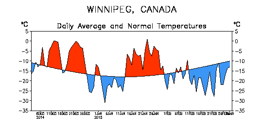
Winter 2015-2016 brought just what was predicted to southern Manitoba: much warmer than normal conditions, a shorter winter and a lack of major snowstorms overall (except the week before Christmas).

Daily temperature departures from normal from December to February in Winnipeg, via NOAA

One of the Strongest El Ninos on Record

Whether or not this past winter featured the strongest El Nino on record has not been confirmed yet. There are many indices that measure the strength of El Nino and their values are still preliminary. Nonetheless, the Oceanic Nino Index (ONI) is one of the primary indices. It measures the 3-month average sea surface temperature departure from normal in the Nino 3.4 region (the central Equatorial Pacific Ocean). The ONI peaked at 2.3 in the November to January period, tied with the winter of 1997-1998 for highest on record since records began in 1950. Without a doubt, this past winter joined the winters of 1982-1983 and 1997-1998 for the top three strongest El Ninos since 1950.

CategoryTotal/AverageDeviation From NormalRank (Since 1872)
High Temperature-7.1°C+ 2.4°C13th warmest (tie)
Mean Temperature-11.3°C+ 3.2°C9th warmest
Low Temperature-15.4°C+4.0°C7th warmest (tie)
Rainfall0.4 mm (est.)- 4.2 mm69th rainiest (tie)
Snowfall85.0 cm+ 23.1 cm24th snowiest
Precipitation53.1 mm (est.)- 1.2 mm60th driest

A Top 10 Warmest Winter With a Lack of Cold Days

With an average mean temperature of -11.3°C in Winnipeg, winter 2015-2016 was the 9th warmest winter on record since 1872.

Top 10 Warmest Meteorological Winters (Dec-Jan-Feb) in Winnipeg Since 1872

RankMean TemperatureYear(s)
1-7.2°C1877-78
2-8.2°C1997-98
3-9.5°C1986-87
4-9.7°C2011-12
5-10.1°C1930-31
6-10.8°C1991-92, 2005-06
8-10.9°C1982-83
9-11.3°C2015-16
10-11.6°C1999-00

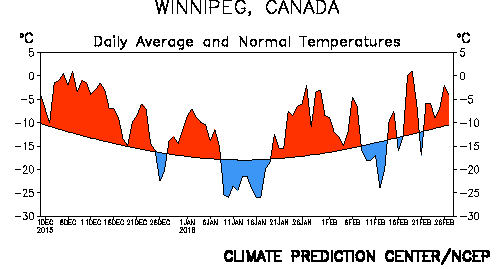
There was a notable lack of cold days from December to February with just 30 days dipping below -20°C. This was well below the 1981-2010 normal of 46 days and tied with the winter of 1918-19 for 8th least -20°C days since 1872. In addition, only 1 day dipped below -30°C, the third least -30°C days on record since 1872. The winters of 1930-1931 and 2011-2012 were the only ones to not see one day below -30°C and this winter was the only one to see just 1 day below -30°C. The 1981-2010 normal is 13 days below -30°C.

Winnipeg's Winter Ice Festival 2016
Despite warmth, it was still cold and snowy enough for Winnipeg’s winter festivals. The Ice Show, shown here, was a new addition this winter. Credit: ManitobaHot.com

Winter’s Late Arrival

A significant warm spell occurred in the first half of December, delaying the arrival of sustained winter conditions until mid December. In fact, it was the second warmest first half of December on record since 1872 in Winnipeg with an average mean temperature of -3.0°C. 14-consecutive days from the 3rd to 16th never dropped below -9°C and 8-10 days exceeded freezing. The only record broken during the warm spell was on December 9 when a high of 5.6°C at the airport broke the old record of 5.1°C in 1990. No snow was on the ground in parts of southwestern Manitoba and in the Morden-Winkler area allowing temperatures to reach double digits. In Morden, four days exceeded 10°C, three of which were record highs. The high of 14.2°C on December 4 was the third warmest on record in December since 1904. Some thermometers reportedly reached 15°C, more typical of late September or early October. A similar milestone was reached in Brandon with a high of 11.1°C on the 4th, the third warmest temperature in December since 1890.

In the end, it was the 9th warmest December since 1872 in Winnipeg with an average mean temperature of -8.1°C.

Stormiest Part of Winter

Winter, once it finally arrived, came in with a bang on December 16 thanks to a major Colorado Low. About 20 cm fell in Winnipeg, 18 cm of which fell on December 16 alone breaking the old record of 8.4 cm in 1942 for the day. Two additional snowstorms before Christmas dumped another 20 cm. Thanks to the snowfall, snow depth in Winnipeg sat at 30 cm on Christmas morning, the deepest snow pack on Christmas Day in 15 years (since a 30 cm depth in 2000). In total, 44.0 cm of snow fell in Winnipeg in December, 83% above normal and the 12th snowiest December on record since 1872.

January and February – Mild With Just Two Brief Cold Spells

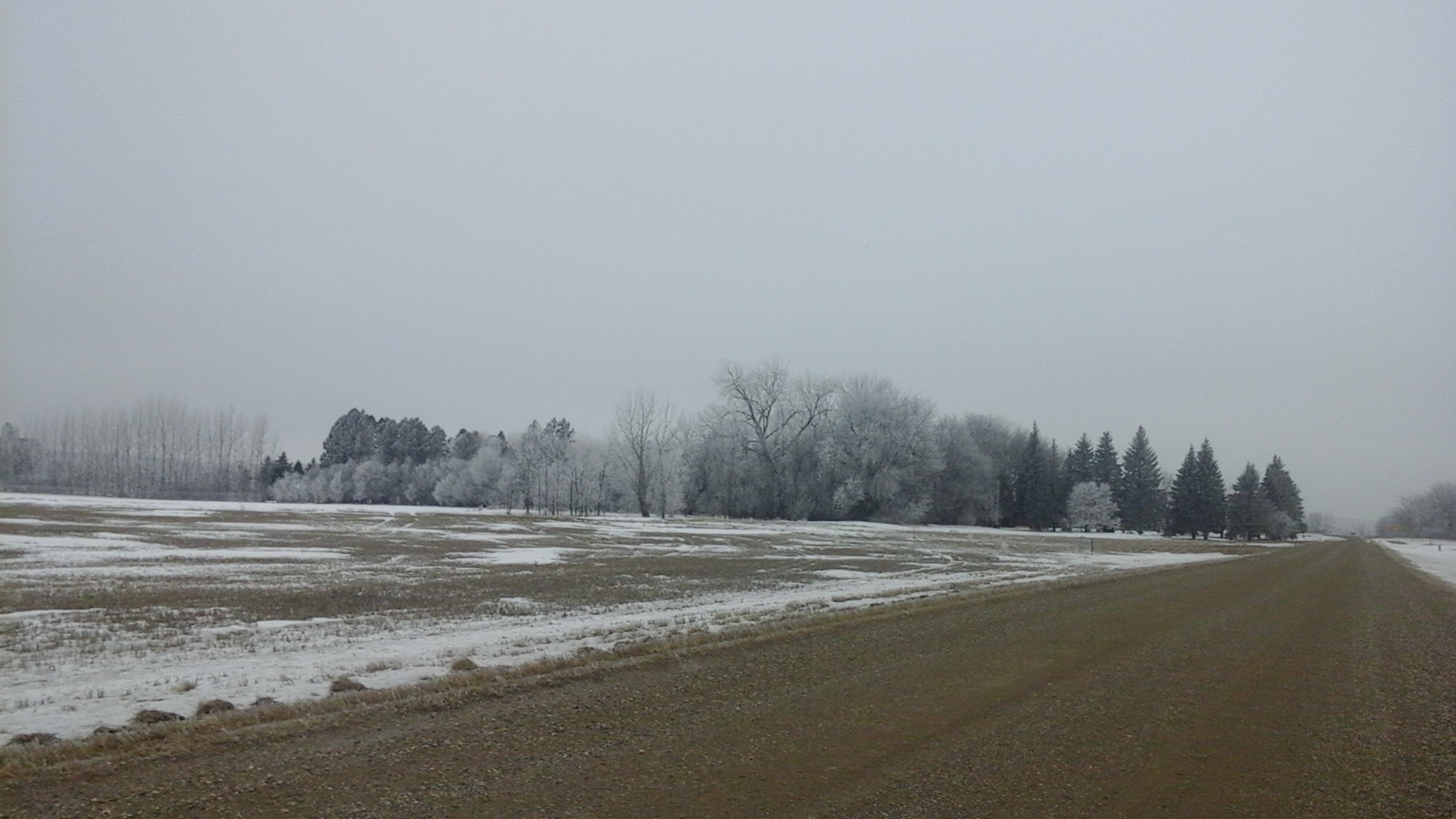
The worst cold spell of the winter was in early to mid January from the 9th to the 19th. 5 days never rose above -20°C. The coldest night of the winter was on the 17th with a low of -32.3°C, the only -30°C day of the winter. Another brief cold spell occurred from February 8th to 13th, but was not very significant. The coldest temperature was only -27.9°C. Other than that, conditions were near to above normal, making for an easy mid-winter. It was warmest in late January and late February with a combined 8 days above freezing in Winnipeg. The late January warm spell in particular was sufficient to erode much of the snowpack in southwestern Manitoba thanks to warm temperatures and rainfall. Fields were nearly bare from Morden to Melita. Without much snow in February, these areas maintained a very thin to non-existent snowpack up until March. This allowed for warmer temperatures with highs reaching 9°C in Melita in early and late February.

Hoar frost and lack of snow south of Winkler February 1, 2016

In the end, January averaged -14.6°C in Winnipeg, 1.8°C above normal and tied 29th warmest since 1872. February averaged -11.1°C, 2.4°C above normal and tied 22nd warmest since 1873. This was only the second warmer than normal February since 2005.

February Thundersnow

Even some thundersnow occurred not far from the US border in late February, an extremely rare event in this area. One lightning strike was recorded northeast of Altona just after midnight on February 23. Even stronger thundersnow occurred just south of the border near Langdon, ND in the evening on February 28.

Remarkably Warm February Out West

The further west you went in the Prairies, the warmer it was in February. Cold snaps generally remained to the northeast and there was little to no snow on the ground from Melita, MB westward to Calgary, AB. Persistent warmth was the story in this area, especially in southern Alberta. After February 3rd, every single day exceeded the freezing mark in Calgary and this streak has continued into March. In addition, 7 days in February reached double digits with a monthly high of 16.9°C on February 26. There was also a lack of snow with not a single snowfall from February 2nd to 27th. With just 1.8 cm, it was the 5th least snowy February since 1885 in Calgary. Lethbridge, AB was even warmer in February with 15 days reaching double digits. Saskatchewan also received this extreme warmth. Only 11 days failed to exceed the freezing mark in Regina. The monthly high was 13.2°C on February 26, the second warmest temperature on record in February since 1884.

From east to west, here’s how February averaged and ranked across the southern Prairies:

CityAverageDeviation From NormalRank
Winnipeg, MB-11.1°C+ 2.4°C22nd warmest (tied)
Brandon, MB-9.3°C+ 4.3°C7th warmest
Regina, SK-4.5°C+ 7.6°C4th warmest
Calgary, AB1.4°C+ 6.8°C2nd warmest

North Dakota Record February Warmth

The warmth was also extreme to our south in North Dakota. Bismarck, located in southwestern North Dakota, reached a record 23°C on February 27. This was the warmest temperature ever recorded in North Dakota in February, breaking the old record of 22°C in 1992.

State of the Climate: Meteorological Winter 2014-15

Daily temperature anomalies this winter (source)

This winter has been much easier to handle compared to last year. Despite frigid conditions returning in February, meteorological winter 2014-2015 still averaged close to normal thanks to warm conditions in December and January. The 3-month period averaged -14.3°C, just 0.2°C above normal. This is 6.0°C warmer than last winter!

Meteorological winter rankings for Winnipeg
Category Winter 2014-15 Total/Avg. Rank (Since 1872–73)
High Temp. –9.5°C Tied 42nd Warmest
Mean Temp. –14.3°C Tied 33rd Warmest
Low Temp. –19.0°C Tied 35th Warmest
Rainfall 1.2 mm (est.) 48th Rainiest
Snowfall ~ 43 cm 28th Least
Precipitation ~ 31 mm 9th Driest

Mild & Lack of Snow in December and January

December was the warmest month of the winter, averaging -10.0°C. This was 3.5°C above normal and a whopping 10.9°C warmer than in 2013. Many people would probably remember December for its gloominess however. Several consecutive days of cloud, fog and freezing drizzle occurred. In fact, freezing drizzle fell on 7 days. The cloud kept our daytime highs cooler than they could have been, but helped keep us warm at night. In fact, 3 daily high minimum records were broken. Most notable was a low of -0.5°C on December 12 which broke the old record of -3.9°C back in 1877, Winnipeg’s warmest December on record. Sunshine made more of an appearance in southwestern Manitoba where highs well above zero occurred. Even a few double digit highs were recorded close to the US border. For instance, Deloraine reached 10.3°C on December 11.

There was also a lack of snow in December. Just 7.2 cm fell in Winnipeg, the 16th least snowiest December since 1872. In addition, snow depth never rose above 10 cm. Some areas close the US border even experienced a brown Christmas. The photo below is from Emerson on Christmas Eve morning.

Emerson on Christmas Eve morning

After a cold snap to start 2015, the warmth returned mid January. Temperatures exceeded the freezing mark, nights were unusually mild and what little snow there was on the ground was melting. In the end, January finished 2.7°C above normal, tying with 2010 for 19th warmest. Thanks to melting, snow depth was just 12 cm at the end of the month, the 12th thinnest snow pack at the end of January since 1941.

In total, 11 days in December and January exceeded the freezing mark in Winnipeg, above the normal of 7 days.

February Cold Snap

Winter made its presence well known in February. The month was awfully reminiscent of last year with seemingly endless colder than normal conditions. The month averaged -19.2°C, 5.7°C below normal and the 27th coldest February since 1873. 21 days dipped below -20°C, above the normal of 14 days. The monthly high was a measly -3.1°C. In fact, only 6 days rose above -10°C, tied 10th least since 1873. This February was the 10th colder than normal February in the last 11 years. Since 2005, only 2012 had a warmer than normal February.

Lack of Snow This Winter

Approximately 43 cm of snow fell from December to February (exact amount to be confirmed), about 19 cm below normal. Even more unusual, only approximately 31 mm of precipitation fell making it the 9th driest meteorological winter since the winter of 1872/1873. Now in March, snow depth only sits around 20 cm in Winnipeg.

A Look Back at 2014

I will end this post with a quick look back at the cold year that was 2014. The year averaged 1.2°C, 1.7°C below normal. In fact, it was the coldest year since 1996. Although it was only tied 28th coldest since 1873, it was the 9th coldest in the last century. This was in large part thanks to the very cold winter and spring we experienced.

Monthly & year-to-date temperature deviations for 2014 in Winnipeg, MB

As for precipitation, 2014 was slightly drier than normal in some parts of the city and wetter than normal in others. Approximately just less than 500 mm of rain fell officially at the airport, slightly below the normal of 527 mm. It was wetter in southern and southwestern parts of the city where heavy thunderstorms dumped locally flooding rains in the summer. Well over 400 mm of rain fell in these locations. At my place in South St. Vital I recorded 450.0 mm of rain and 550.6 mm of precipitation.

Monthly & year-to-date precipitation amounts for 2014 in Winnipeg, MB
Monthly & year-to-date precipitation amounts for 2014 in Winnipeg, MB. Data combined from the James Richardson International Airport and The Forks.
Overall, snowfall was close to normal with 118.4 cm (normal is 117.3 cm). Nearly 80% of this fell from January to April. As mentioned already, there was a notable lack of snow in December.


Note: Unless otherwise noted, all normals stated in this post are the 1981-2010 normals. I use the normals that I have calculated which you can see anytime by following this link.

State of the Climate: The Year So Far

Editor’s Note: Something I’ve wanted to do far more frequently than I’ve been able to is comprehensive climate statistics for Winnipeg. In between the regular posts, occasional event summaries and keeping this website humming along, I simply haven’t had the time time to get my personal climate archive quite up to snuff yet to really dig into things. So, I’d like to introduce a new contributor to the AWM team, Julien (@jjcwpg on Twitter). He’s the proprietor of Winnipeg Weather, does fantastic work with climate statistics[1] and will be in charge of seasonal climate updates as well as summer severe weather climatologies, similar to his guest post covering last summer’s thunderstorm statistics across the province. Since Julien is joining the team mid-season, we’re doing a “Year so Far” climate summary to bring readers up to speed on the current climate story for Winnipeg – hint: it’s cold – and to introduce him. So without further ado, here’s the first post of our new feature: State of the Climate!


Quite the year so far!

It’s no secret that 2014 has been an unusually cold year so far; in fact, we’ve managed to reach some impressive milestones in the last few months. Our brutal winter is now long gone and most of you probably want to forget about it (me as well), but before doing so I do have some interesting statistics about the winter of 2013/14 that I think are worth sharing.

To start off, this past December to March period didn’t only feel like one of the harshest ever recorded in Winnipeg, it statistically was. Our mean temperature (an average of all daily highs and lows) was -18.4°C, making it the coldest December to March period in 115 years. However, because we only tied with the winter of 1898-1899 for 11th coldest, we have to go back 121 years to find a December to March period that was even colder than this year’s. With 124.6cm of snowfall, it was also the 12th snowiest December to March period. Combining 12th snowiest with 11th coldest truly made this past winter one of the harshest since records began in Winnipeg in 1872.

In total, there were 90 days below -20°C between December and March, tying 6th most since 1872 and the most in 121 years! That’s 74% of all available days! The 1981-2010 normal is 51 days. The following table summarizes the number of -20°C and -30°C days we had from December to March.

Days below -20°C and -30°C
December 2013 to March 2014
Month Days below -20°C Days below -30°C
December 25 (tied 6th most) 9 (tied 15th most)
January 26 12
February 24 (tied 13th most) 6
March 15 (tied 20th most) 2
Total 90 (tied 6th most) 29 (tied 19th most)
Anything within the top 20 is noted.

The winter minimum was -38.0°C on January 5, the coldest temperature in Winnipeg since a -41.7°C low in February 2007. The high of -30.2°C for the day was not only a record low maximum but also the coldest since a -30.8°C high on Jan 30, 2004.

Many of you might remember the super cold day we had on March 1. Well, I’d say that was the most anomalous day of the winter. The low of -37.0°C that day was actually the 9th coldest in March since 1872. The high of -26.0°C obliterated the old record low maximum of -22.2°C in 1972 and was the second coldest in March on record. The mean temperature for the day was -31.5°C, making it the second coldest March day since 1872. In fact, this was a whopping 21°C below normal for the day, almost as extreme as March 2012’s 23.7°C above normal on March 19, 2012. Of course, to Old Man Winter all this was not enough. A minimum hourly wind chill value of -49.6 at 7 am was the lowest ever in March since 1953. Previous record was -48.8 in 1962.

Cold Not the Only Story of 2014

Despite all the cold weather news to talk about this year, one warm record managed to stand out. On January 15, a high of 3.3°C broke the old record high of 2.2°C in 1973. However, this high was an amazing 30.7°C increase from a low of -27.4°C in the morning, the greatest single-day warmup on record since 1872[2]. The top 5 are given in the table below. The 30.7°C warmup took about 14 hours and peaked between 4 and 5 pm when the temperature rose 5-6°C in just 1 hour.

Top 5 Greatest Calendar-Day Warmups since 1872
Rank Temperature rise of… Date
1 30.7°C Jan 15, 2014
2 30.6°C Jan 20, 1874
2 30.6°C May 12, 1949
4 30.5°C May 19, 1899
4 30.5°C Jan 30, 1934
Note the fact that this statistic doesn’t consider how quickly the temperature rose.

Nonetheless, the cold will forever be remembered as the top story of early 2014.

Stubborn cold continues into spring

In more recent memory, the cold continued into April with near record lows at times mid month. At 4.2°C below normal, April was the 5th consecutive month averaging over 3.5°C below normal and 7th consecutive month averaging below normal in general; a streak which began in October. In fact, up to April 30 we’ve averaged -13.1°C for 2014, 5.3°C below normal for the period. This ties with 1996 for 15th coldest first third of the year since 1873 and 4th coldest in the last century. The following graph shows how each month so far this year has averaged compared to the 1981-2010 normal as well as the year-to-date average compared to normal.

2014 Monthly and Year-To-Date Temperature Deviations for Winnipeg, MB

Yet another couple impressive statistics have come from this year’s cold. Our winter snow pack still sat at 43cm deep on April 1, the 3rd deepest winter snow pack entering into April since 1955. It didn’t reach a trace cm until April 19, the 3rd latest on record, and disappear until April 21, the 8th latest on record.

Thank you for reading and we hope you all enjoyed this first State of the Climate post!


  1. Seriously, the number of stats he’s worked out is fantastic!  ↩
  2. In this case, when referring to a single day we mean a single calendar day.  ↩