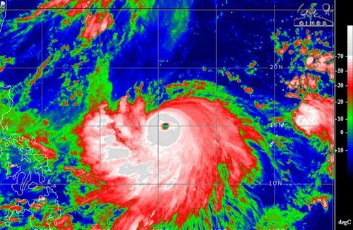
Weak Storm Forms in the Atlantic; Typhoon in Pacific
The second named storm of the Atlantic hurricane season spun up this past week and is still churning in the Caribbean. Tropical storm Bertha had sustained winds of around 80km/h as of Friday evening but had lots of dry air to its south and was not very well organized. By this evening it is expected continue its northwest track and pass between Puerto Rico and the Dominican Republic, bringing with it heavy rains as its primary threat. As much as 250mm of rain can be expected in the area which is a cause for concern in the mountainous regions. However, Puerto Rico has been experiencing drought for the past few months; the rain in the forecast is actually a welcome sight. On Sunday Bertha will have more of a northward track, curving up the Gulf Coast and likely dying off to the west of Bermuda due to cooler sea surface temperatures. None of the weather models show Bertha strengthening into a major hurricane and the US mainland is not expected to be impacted by this storm.
A large, more dangerous tropical disturbance has formed in the western Pacific this week and is already of category three status with sustained winds of 185km/h. Halong has a well-defined eye and eyewall in place, the only thing currently interfering with its development is some dry air to its north. The typhoon is currently located well east of the Philippines and is expected to be of no threat to the country as it will quickly curve Poleward this weekend. It, however, could pose a significant threat to Japan and China next week as it moves into the East China Sea as a strong typhoon. The islands of Okinawa could be in for a strong storm, as depicted by some models, but it is really too early to say for sure.

