Our shot of winter this week won’t look so bad by this time next week! Slightly warmer temperatures today will be followed by some light snow tonight and a dreary but milder weekend, before the coldest airmass we’ve seen this winter settles in over much of the Prairies.
Today will bring warmer temperatures as Pacific air pushes east-southeast across the Prairies. Temperatures should be able to make it up a little past the -15°C mark by early to mid-afternoon. Clouds will roll in by evening, and we should see some light snow in the evening and overnight with temperatures staying fairly steady overnight as warmer air continues to push into Southern Manitoba. Winnipeg will likely see 2-4cm of snow as relatively high snow to liquid water ratios (SLR) are expected, around 15:1 to 20:1.
Snow to Liquid Water Ratio (SLR) is a measure of how much snow is produced per millimetre of water. For example, a SLR of 20:1 would mean that for each 1mm of liquid water that fell, there would be 20mm, or 2cm. If someone received 10cm of snow, and that was melted and resulted in 4mm of water, then the SLR would be 25:1. The higher the SLR is, the ‘fluffier’ the snow.
Milder temperatures will be seen in the southwest and south-central portions of Manitoba on Saturday and Sunday. Temperatures will reach between -10°C and -5°C in the Red River Valley this weekend, with relatively light winds and plenty of cloud.
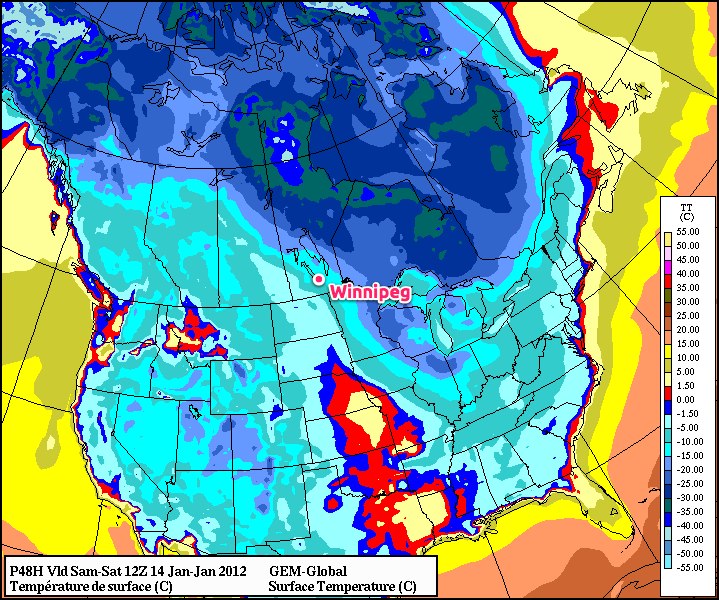
We could see some light snow on both days as well, but significant accumulations (2+ cm) are unlikely. The days may be a little dreary, but enjoy the warmer temperatures while you can. Next week will be shockingly different.
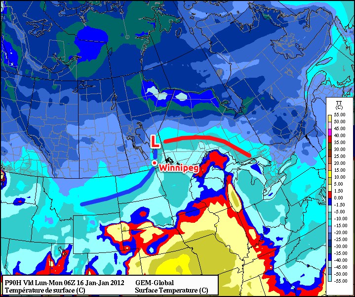
Early Monday morning, a cold front will sweep through Southern Manitoba, ushering in a completely different weather regime. We’ll see steady or dropping temperatures through the day Monday with some accumulating light snow through much of the RRV, especially north of Morris. Current indications show that 2-4cm looks reasonable, with 5-10cm possible for areas north of Winnipeg. Snowfall amounts in the City of Winnipeg will be sensitive to the exact track of the low, so we’ll keep an eye on that system as it develops.
The entire change will be driven by a long wave trough rotating southeast from Alaska into the Central Prairies. This will drive the jet stream south into the Northern U.S., allowing bitterly cold Arctic air to spill southwards into the Prairies. Just how cold is it going to get?
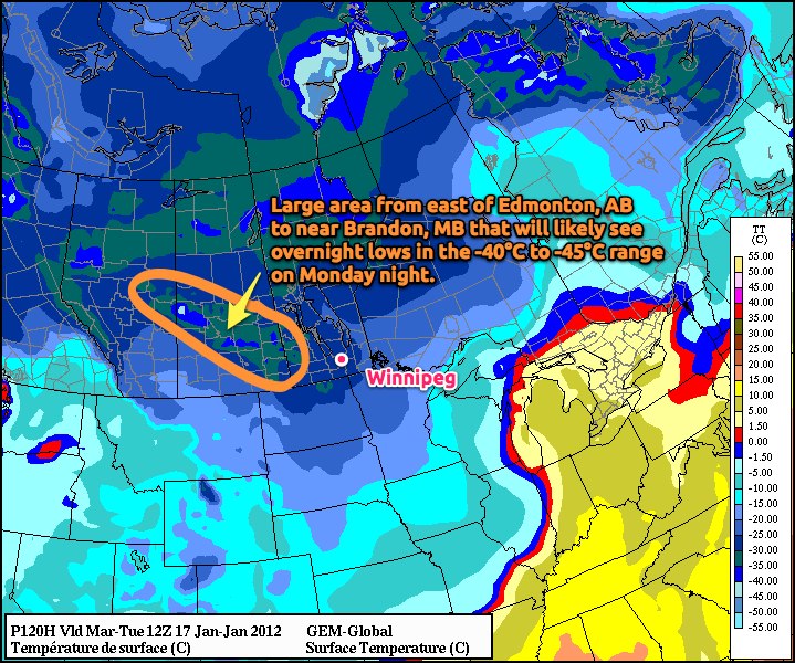
The coldest air we’ve seen all winter at 500mb will be pushing into the Prairies, with temperatures at that height forecast to be between -40°C and -45°C over most of the Prairies. What does this mean for temperatures at the surface? The GEM-GLB model is currently forecasting a swath through East-Central Alberta and Central Saskatchewan that will experience overnight lows between -40°C and -45°C!
For the third week of January, average daytime highs are around -13°C and average overnight lows are around -23°C. We will be several degrees below normal for a couple days next week.
This cold air will slump southeastwards bringing bitterly cold temperatures into Southern Manitoba, with overnight lows near -30°C and daytime highs struggling to climb above -20°C. By mid-week, temperatures may moderate into the mid-minus-teens as some cloud cover spills into the Southern Prairies associated with a system tracking through the Northern Plains. It may feel extremely cold, however, as we may be dealing with stiff northeast winds as the system moves through the area.
The cold air looks to be entrenched for the whole week, but we’ll have more on that on Monday. Get out and enjoy the weekend as best you can! It’s hot drinks and oatmeal weather next week!