After an extraordinarily warm start to January, our weather is about to take an abrupt turn toward very cold conditions. It was only last Tuesday that temperatures were well above zero in Southern Manitoba. By the time this Tuesday rolls around, conditions will be starkly different.
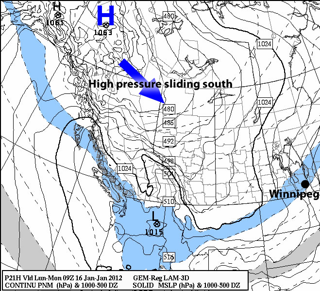
The colder weather that is currently overtaking the Prairies is the result of a low pressure system that crossed the region on Sunday. As the low raced across the Prairies, it dragged down an arctic air mass in its wake. This arctic air mass will be centred around a 1040mb high pressure system, which is currently in the process of breaking away from a much larger 1063mb high over the Yukon. While in summer high pressure usually means warm and sunny conditions, in winter a large high pressure system usually means sunny but very cold weather.
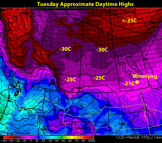
Temperatures in Southern Manitoba on Monday will be in the mid to high minus teens, which is slightly below normal for this time of year (normal high is -13C). However, by Tuesday it looks unlikely that temperatures will rise above -20C during the day. Despite the very cold high temperatures that are expected this week, overnight lows will not be that extreme in Southern Manitoba. Currently it doesn’t look like we’ll get much below -30C in most areas (save for Thursday, when we might see an extremely cold morning). Wind chill values toward -40 are entirely possible this week, especially in the morning hours when actual temperatures are still very cold. Our neighbours to the west in Alberta and Saskatchewan will be much worse off, as low temperatures in those provinces are expected to hit -40C this week.
In the longer range it appears unlikely that we will return to the very warm conditions that we experienced earlier this month. However, that doesn’t mean the rest of January will be extremely cold. We don’t yet know how long this cold spell will last, though bear in mind that arctic air is very dense and does not like to move quickly. In terms of snow, weather models are showing a return to a stormier pattern for the rest of January. It looks as though a minor weather system may give Southern Manitoba a couple centimetres of snow on Tuesday. Other than that, it doesn’t look like we’ll see any snow until next weekend at the earliest. Typically colder patterns tend to bring more snow than warmer patterns. This explains why our winter has been fairly snow-free thus far.
Elsewhere in Weather News
US Tornado Season Kicks Off Early in 2012
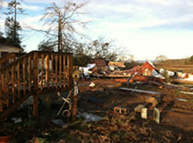
One of the Unites States’ first significant tornadoes of the 2012 storm season has caused quite a bit of damage in western North Carolina on January 11th 2012. What caused the tornado was a potent cold front pushing across the region coupled with just the right amount of instability and shear. This storm system was associated with a low pressure system moving up the east coast and bringing unseasonably warm and moist air to the south-east states. The EF-2 tornado (about 115mph wind speeds) caused major structural damage to at least 50 homes and knocked out power to 800 homes in the North Carolina area. Thankfully no fatalities were related to this tornado.
Ironically on the back side of this low (where the high pressure dome is moving in) winter is set to arrive with gusty winds and snowfall. The tornado’s cleanup will have to be done in wintery conditions.
2012 Starts Off With Extremes in Australia and Europe
Australia’s summer has started off as a sizzler in 2012 and Europe has had record snowfalls. Both these cases are examples of how extremes have already shown up in 2012. Southern Australia has produced some extreme averages; lows of 30ºC and continuous highs of 45ºC or more (7ºC+ above average). These extremely warm temperatures are causing brushfires to spring up almost anywhere in Australia’s southern counties, keeping firefighters on the go.
Meanwhile parts of Europe have had snowfalls that have buried them in snow which has left many ski resorts, including Zugspitze summit in Germany, covered. In this location there was less than a foot of snow a couple weeks ago, however now that several powerful systems have passed, more than 6 feet of snow have accumulated there!
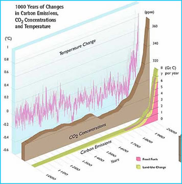
Many scientists believe that these extremes come down to how the Arctic sea ice has diminished significantly in the last couple years and how greenhouse gas levels (CO2) have been rising to an unprecedented level. One can also assume that these extremes happen naturally and the Earth is simply going through a warm cycle, as there is no exact proof that these could be the cause – it is for you to decide!
Elsewhere in Weather News has been provided by Matt.